



Regional Super El Niño Impacts: South Central U.S.
Explore the forecasted impacts of the 2026 El Niño on the South Central U.S. and its implications for the management of natural resources.
States covered: Louisiana, New Mexico, Oklahoma, and Texas
What Does El Niño Mean for the South Central U.S.?
Precipitation Changes
Late-fall, winter, and early spring precipitation amounts rely on low-pressure systems (“lows”) or their associated fronts to move across the region. Three major sources of lows affect some part of the region during winter: (1) the jet stream, (2) cyclogenesis (i.e., creation of a low) in the lee of the Colorado Rockies (called a “Colorado Low”), and (3) cyclogenesis across the large temperature difference between colder lands and warm Gulf waters (called a “Gulf Low”), primarily near the Louisiana coast. El Niño events affect the first of these by forcing the jet stream to move southward over the southern U.S., resulting in more frequent lows passing across the region. Research also indicates that Gulf Lows are more common during El Niño years, perhaps because the altered jet stream track brings cooler temperatures to the coast and, thus, larger cross-coastline differences in temperature. As a result of these changes, most of the region experiences more frequent precipitation events. With more moisture available in a warming atmosphere, some of these events may bring heavy rainfall or snowfall.
For New Mexico, above-normal precipitation during El Niño winters tends to occur less frequently in northwest and north-central areas and at higher elevations than across the rest of New Mexico. Most of Oklahoma experiences above-normal precipitation during El Niño winters, but eastern Oklahoma tends to experience heavier events because of the northward flow of Gulf moisture as lows pass through the state. Central and eastern Texas also frequently have above-normal precipitation during El Niño winters, while this pattern is not as frequent across western Texas. All of Louisiana experiences a high likelihood of wetter-than-normal conditions during El Niño events.
Temperature Changes
Cool-season temperatures across the region are strongly influenced by the location of the jet stream and the surges of cold air that accompany cold fronts. The more southerly jet stream, and its steering of lows and cold fronts more frequently through the region, has brought cooler-than-normal temperatures during El Niño events. In New Mexico, the Texas Panhandle, and Oklahoma, these cooler temperatures can lead to snow rather than rain when precipitation occurs. In addition, with a stronger jet stream and more frequent low-pressure systems, there are higher chances of ice storms and blizzards during El Niño years across the region. On the other hand, outbreaks of extreme cold temperatures, such as the February 2021 cold-air outbreak (i.e., Winter Storm Uri), are less likely because they usually occur when the jet stream is weak and wobbly.
Hurricanes
The strong El Niño conditions in the Pacific leads to increased vertical wind shear in the tropical Atlantic Ocean, which can limit the formation of tropical cyclones especially in the main development region between the Caribbean Islands and Africa. Therefore, forecasters are expecting fewer tropical cyclones to form this fall. It doesn’t mean no hurricanes will form, nor that a major hurricane won’t make landfall in the U.S.; rather, this strong El Niño means the odds are shifted toward fewer storms. These odds don’t necessarily suggest autumn will be dry along the Gulf coast, but it does suggest a lower likelihood of flooding from tropical cyclones.
Learn more about El Niño and hurricanes>>
Serious Flood Hazards
A strong jet stream can become anchored across the southern U.S. during the cold season when a strong to very strong El Niño occurs. As a result, many locations can experience a series of large storm systems for weeks and associated heavy precipitation. Extreme runoff is a risk with saturated or frozen soils, areas with recent burn scars, or rain-on-snow events. Flooding hazards, include flash flooding, become a major concern during strong El Niño events. In New Mexico, El Niño-influenced snowpacks and spring warming can lead to rapid snowmelt that overflow rivers, arroyos, acequias, and urban drainage systems. Flash flooding of low-lying or urban areas and moderate-to-major river flooding in Oklahoma and Texas have been associated with past El Niño events. In Louisiana, regional waterways, the Mississippi River, and deltas have experienced extensive flooding in prior events.
Major Winter Storms
The strong jet stream expected across the region during a Super El Niño event carries an amazing amount of atmospheric energy, leading to intense lows that can bring the high winds and heavy precipitation of a major winter storm. It is more likely during a Super El Niño for the region to experience multiple major winter storms as compared to a normal winter. Sea-surface temperatures in the Gulf have been warmer than normal (as of August 17, 2026), leading to more evaporation and more available moisture for storm systems. If tropical storms in the Gulf are absent this fall, or if they do not stir cooler waters to the surface, this moisture will be fuel for low-pressure systems in much of the region. Depending on how the temperature changes with height in the winter storm (i.e., vertical temperature profile), precipitation can be heavy rain, heavy snow, sleet, or ice. Historically during Super El Niño events, damaging ice storms have been more common in the eastern half of the region, particularly Louisiana, while blizzards have plagued the western half.
Learn more about El Niño and snow>>
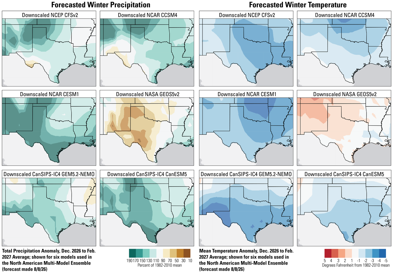
Comparison of Seasonal Forecast Models for 2026–2027 Winter Weather Conditions in the South Central Region
There are differences among seasonal forecast models, and in areas where those differences are larger, confidence in the forecast is lower. We don’t yet know which model will be the most accurate. Overall, the six seasonal forecast models used as part of the North American Multi-Model Ensemble suggest higher precipitation totals across most of the region, consistent with the changes in the location of the jet stream. The one outlier model likely shows lower precipitation across much of the region because it is not forecasting the jet stream to move as far south as what typically occurs during El Niño years. All models forecast wetter-than-normal conditions along the Gulf Coast, aligning with the land-atmosphere interactions that are expected during El Niño events. Five of the models predict cooler-than-normal conditions across much of the region. The one outlier model likely shows warmer-than-normal temperatures because it is not forecasting the jet stream to move as far south as what typically occurs during El Niño years.
What Does This Mean for the Management of Natural Resources?
Although the seasonal impacts of the 2026–2027 Super El Niño are not guaranteed, the strength of this event does increase the likelihood that the jet stream will be strong and shift southward to be over or near the southern U.S. for much of the cool season. Impacts likely will be most evident during winter but can begin as early as September 2026 and last well into spring 2027. Natural resource managers can start planning now.
For those areas of New Mexico, Oklahoma, and Texas suffering through an extended drought, above-normal precipitation could be beneficial. Significant aquifer recharge in karst topography and from playa lakes or other wetland areas will be beneficial if the storm systems allow time for recharge to occur. With hard soils and heavy rainfall, runoff may be extensive and flash flooding may lead to significant erosion or even landslides. Managers may want to pay particular attention to burn scars, as post-fire restoration efforts with seedlings may be negatively impacted by runoff. Trails, roads, or other recreation area infrastructure that has been susceptible to erosional damage in the past may be at higher risk this cool season. In addition, wetter-than-normal conditions have encouraged significant vegetation growth when temperatures warm in springtime. The thick foliage can become an extensive fuel supply for wildfires in any subsequent drought, so managers can prepare to implement vegetation management plans for fuel reduction. Private landowners and absentee landowners may not be prepared for fuel reduction activities, so emergency managers can work locally to educate and encourage proactive activities to reduce future risk.
Flight patterns for migratory birds and food supplies for wildlife may shift significantly with the increased risk of major winter storms. The timing of runoff will be particularly important for fish spawning, and severe flood flows wash away eggs, scour streambeds, or displace juveniles. Water-breeding insects, such as mosquitos, find additional water supplies favorable, even though some breeding efforts are interrupted by fast-moving water. With enhanced surface waters as temperatures warm during springtime into summer, larger mosquito populations may increase the risk of mosquito-borne diseases such as dengue, chikungunya, and Zika.
Major winter storms can interrupt power transmission for days to weeks, strand herds of livestock and wildlife without food for days, freeze farm ponds and other freshwater supplies, and close access roads. Ice storms can add significant amounts of potential wildfire fuel to the landscape through downed trees and branches. Electrical outages may affect water security, as water and wastewater facilities lose power. Workers may become stranded because of flooded or snowed-in roads or may be unable to communicate during outages. Managers can plan ahead to have food, water, debris-removal equipment, and backup plans ready in case this happens.
Questions?
Contact the South Central CASC if you’d like to discuss this El Niño and adaptation strategies for management of your resources.