



Regional Super El Niño Impacts: Southeast U.S.
Explore the forecasted impacts of the 2026 El Niño on the Southeast U.S. and its implications for the management of natural resources.
States and U.S. territories covered: Alabama, Arkansas, Florida, Georgia, Mississippi, North Carolina, Puerto Rico, South Carolina, Tennessee, and the U.S. Virgin Islands
What Does El Niño Mean for the Southeast U.S.?
Hurricanes
The strong El Niño conditions in the Pacific lead to increased vertical wind shear in the tropical Atlantic Ocean, which can limit the formation of tropical cyclones, especially in the main development region between the Caribbean Islands and Africa. Therefore, forecasters are expecting fewer tropical cyclones to form this fall. This doesn’t mean that no hurricanes will form, nor that a major hurricane won’t make landfall in the U.S.; rather, this strong El Niño means the odds are shifted toward fewer storms. These odds don’t necessarily suggest autumn will be dry in the southeastern U.S., but they do suggest a lower likelihood of flooding from tropical cyclones. In contrast, these odds suggest that the ongoing drought conditions in the U.S. Caribbean may continue, because that region is more directly dependent on precipitation from tropical waves and cyclones.
Learn more about El Niño and hurricanes>>
Winter Storms
Forecasters expect a stronger jet stream with deeper troughs and associated storms that track further south and east. Thus, odds are increased that total precipitation this winter will be higher along the Gulf Coast and Atlantic seaboard. This El Niño pattern is more often associated with an increase in the number of nor’easters and coastal storms that can produce strong, sustained winds and heavy precipitation. The increased odds for storms along the coastal plain also increase the chance of more frequent heavy rainfall that could lead to ponding water and localized flooding. While storms during the winter don’t typically produce the kind of rainfall intensity of thunderstorms or hurricanes, saturated soils may lead to local inland flooding as storm systems move through the region.
The linkage between El Niño and storms with snow and/or ice is not as strong across the Southeast, but it doesn’t rule out winter storms. For much of the Southeast, the difference between rain and snow or ice is often just a temperature difference of a few degrees or a storm track that is shifted by 100 miles (or less).
Learn more about El Niño and snow>>
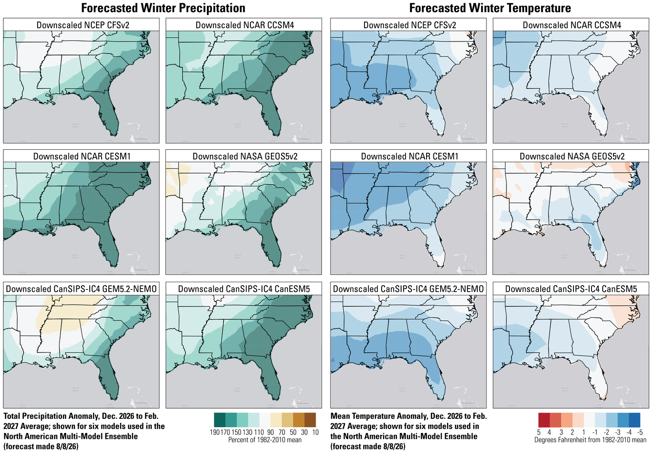
Comparison of Seasonal Forecast Models for 2026–2027 Winter Weather Conditions in the Southeast Region
There are differences among seasonal forecast models, and in areas where those differences are larger, confidence in the forecast is lower. We don’t yet know which model will be the most accurate.
Overall, the six seasonal forecast models used as part of the North American Multi-Model Ensemble generally agree that winter total precipitation will be higher along the Gulf Coast and Atlantic seaboard with less confidence in the Tennessee and Mississippi Valleys. There is less model agreement on seasonal average temperature forecasts for December 2026 through February 2027.
Spring/Summer 2027 Seasonal Forecast
As explained above, there is higher confidence in the outlook for wetter conditions this winter, but there isn’t much insight into climate patterns for the following warm season.
What Does This Mean for the Management of Natural Resources?
Natural resource managers in the Southeast can start planning for how they might manage for wetter conditions, including very wet conditions that might cause ponding or flooding. While very wet conditions are not guaranteed this winter, the odds are shifted toward this outcome. Since much of the Southeast U.S. is dealing with drought conditions, a wet winter would recharge surface and groundwater supplies. However, repeated intense rainfall can also lead to erosion and flooding. In addition, coastal land managers may want to consider the potential ways to adapt to more coastal storms and nor’easters that could produce inundation and overwash events.
Land managers farther inland may want to consider how strong winter storms, with strong sustained winds, might increase downed tree limbs and litter, which could enhance the risks for fire if the summer of 2027 is dry. For managers looking to replant forests, this fall might be an ideal time as wetter conditions over the cool season may lead to improved planting success, but planting approaches should also consider how to manage for saturated soils and ponding from heavy rains.
With foresight into the increased chances of more frequent and intense storms this winter, managers can consider actions that can be taken early to effectively manage ecological and related resources.
Questions?
Contact the Southeast CASC if you’d like to discuss this El Niño and adaptation strategies for management of your resources.