
Widespread Abyssal Landslides Offer New Insights into Cascadia’s Earthquake Recurrence
Far below the ocean surface off the Pacific Northwest coast, earthquake-triggered landslides record the powerful stirrings of the Cascadia Subduction Zone.
New research led by USGS and the Monterey Bay Aquarium Research Institute (MBARI) shows how extensive underwater landslides—triggered by great earthquakes along this 1,000-kilometer-long plate boundary—create sediment layers that preserve one of the longest and most complete records of megathrust earthquakes anywhere in the world.
These deposits, known as abyssal turbidites, form when earthquakes destabilize sediment on the continental slope, sending landslides downslope to settle on the abyssal ocean floor. For decades, scientists have studied these deposits in submarine canyons, where sediments readily flow from the shallow ocean down to abyssal depths. But these submarine-canyon turbidites aren’t always formed by seismic activity; sometimes extreme events such as floods can transport enormous quantities of sediment from the continent to the ocean floor via these canyons.
“Thinking of the subduction zone system more broadly, our team proposed that large earthquakes such as a magnitude-8 or -9 event wouldn’t just leave turbidites in submarine canyons—it should cause slope failures across the base of the continental slope. So that’s what we set out to investigate,” said USGS Research Geologist Jenna Hill, lead author of the study. “By combining high-resolution seafloor mapping and sub-bottom imaging using an MBARI autonomous underwater vehicle, along with sediment cores collected using research vessels and an MBARI remotely operated vehicle, we could identify the landslide, the debris fan, and the associated turbidites as they spread across the seafloor, and confidently tie these deposits to earthquakes.”
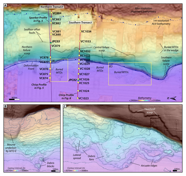
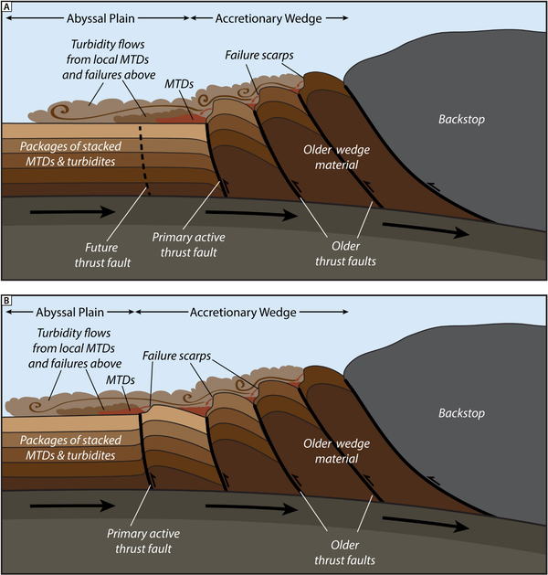
The work focused on a key paleoseismic site in the southern Cascadia margin offshore of northern California, where the Juan de Fuca Plate dives beneath North America. During major earthquakes, widespread failures occur on the lower continental slope here, producing thick, coarse debris deposits close to the slope. Farther offshore, these same deposits fan out to generate complex, layered turbidites that spread across the abyssal plain. Together, the deposits form a continuous, event-by-event record of Cascadia’s great earthquakes.
Crucially, the study identifies the lower continental slope as the primary and recurring source of these earthquake-triggered sediments. As tectonic forces steadily deform the plate margin, thrust folds grow and become oversteepened, recycling the old seafloor and creating a perpetual supply of unstable material. Each major earthquake then releases this stored sediment in a new wave of submarine landslides.
The study notes that these landslides also suggest there may be seafloor offset during large earthquakes, which may heighten tsunami risk along subduction zones, acting as a ramp that pushes tsunamis higher as they travel toward shore.
By clarifying how and where abyssal turbidites are generated, the research strengthens confidence in using these deposits to reconstruct long-term earthquake histories—not only in Cascadia, but in subduction zones around the world. The findings open the door to expanding marine paleoseismic studies into regions where earthquake records are sparse or incomplete.
Read the study, Widespread abyssal turbidites record megathrust earthquake triggered landslides and coseismic deformation in the Cascadia subduction zone, in Science Advances.
Related

Coastal and Marine Geohazards of the U.S. West Coast and Alaska
Related