Search Earthquake Catalog
online search by time window, area, magnitude, and more
online search by time window, area, magnitude, and more
Significant Earthquakes, Past 30 days
Significant Earthquakes, Past 30 days
6.4
245 km NNW of Tobelo, Indonesia
2026-01-10 14:58:23 (UTC)
Pager Alert Level: Green
MMI: VI (Strong Shaking)
31.0 km
6.4
16 km ESE of Baculin, Philippines
2026-01-07 03:02:56 (UTC)
Pager Alert Level: Green
MMI: VI (Strong Shaking)
35.0 km
6.5
4 km NNW of Rancho Viejo, Mexico
2026-01-02 13:58:18 (UTC)
Pager Alert Level: Yellow
MMI: VI (Strong Shaking)
35.0 km
4.9
15 km NNW of Susanville, CA
2025-12-31 05:49:32 (UTC)
Pager Alert Level: Green
MMI: VII (Very Strong Shaking)
5.3 km
6.2
36 km W of Puerto Santa, Peru
2025-12-28 02:51:51 (UTC)
Pager Alert Level: Green
MMI: VI (Strong Shaking)
66.4 km
6.6
31 km ESE of Yilan, Taiwan
2025-12-27 15:05:56 (UTC)
Pager Alert Level: Green
MMI: VI (Strong Shaking)
67.5 km
6.0
2025 Taitung, Taiwan Earthquake
2025-12-24 09:47:06 (UTC)
Pager Alert Level: Green
MMI: VII (Very Strong Shaking)
10.0 km
6.5
42 km NNE of Goroka, Papua New Guinea
2025-12-22 10:31:28 (UTC)
Pager Alert Level: Green
MMI: VI (Strong Shaking)
110.2 km
3.9
10.0 km
4.0
5 km SSE of San Ramon, CA
2025-12-20 03:56:10 (UTC)
Pager Alert Level: Gray (Null)
MMI: IV (Light Shaking)
9.6 km
3.8
5 km SSE of San Ramon, CA
2025-12-20 03:49:28 (UTC)
Pager Alert Level: Gray (Null)
MMI: IV (Light Shaking)
9.6 km
4.0
6 km W of Glen Ellen, CA
2025-12-14 23:30:43 (UTC)
Pager Alert Level: Green
MMI: V (Moderate Shaking)
3.1 km
6.4
245 km NNW of Tobelo, Indonesia
2026-01-10 14:58:23 (UTC)
Pager Alert Level: Green
MMI: VI (Strong Shaking)
31.0 km
6.4
16 km ESE of Baculin, Philippines
2026-01-07 03:02:56 (UTC)
Pager Alert Level: Green
MMI: VI (Strong Shaking)
35.0 km
6.5
4 km NNW of Rancho Viejo, Mexico
2026-01-02 13:58:18 (UTC)
Pager Alert Level: Yellow
MMI: VI (Strong Shaking)
35.0 km
4.9
15 km NNW of Susanville, CA
2025-12-31 05:49:32 (UTC)
Pager Alert Level: Green
MMI: VII (Very Strong Shaking)
5.3 km
6.2
36 km W of Puerto Santa, Peru
2025-12-28 02:51:51 (UTC)
Pager Alert Level: Green
MMI: VI (Strong Shaking)
66.4 km
6.6
31 km ESE of Yilan, Taiwan
2025-12-27 15:05:56 (UTC)
Pager Alert Level: Green
MMI: VI (Strong Shaking)
67.5 km
6.0
2025 Taitung, Taiwan Earthquake
2025-12-24 09:47:06 (UTC)
Pager Alert Level: Green
MMI: VII (Very Strong Shaking)
10.0 km
6.5
42 km NNE of Goroka, Papua New Guinea
2025-12-22 10:31:28 (UTC)
Pager Alert Level: Green
MMI: VI (Strong Shaking)
110.2 km
3.9
10.0 km
4.0
5 km SSE of San Ramon, CA
2025-12-20 03:56:10 (UTC)
Pager Alert Level: Gray (Null)
MMI: IV (Light Shaking)
9.6 km
3.8
5 km SSE of San Ramon, CA
2025-12-20 03:49:28 (UTC)
Pager Alert Level: Gray (Null)
MMI: IV (Light Shaking)
9.6 km
4.0
6 km W of Glen Ellen, CA
2025-12-14 23:30:43 (UTC)
Pager Alert Level: Green
MMI: V (Moderate Shaking)
3.1 km
Earthquake Hazards Program
The USGS monitors and reports on earthquakes, assesses earthquake impacts and hazards, and conducts targeted research on the causes and effects of earthquakes. We undertake these activities as part of the larger National Earthquake Hazards Reduction Program (NEHRP), a four-agency partnership established by Congress.
Latest Earthquakes
Latest Earthquakes

Latest earthquakes map and list (past 24 hours, M2.5+) from the ANSS (Advanced National Seismic System).
Search Earthquake Catalog
Search Earthquake Catalog

Find an earthquake or a list of earthquakes by time window, magnitude, area, and more, and choose the output format - map and list, CVS, and others.
News
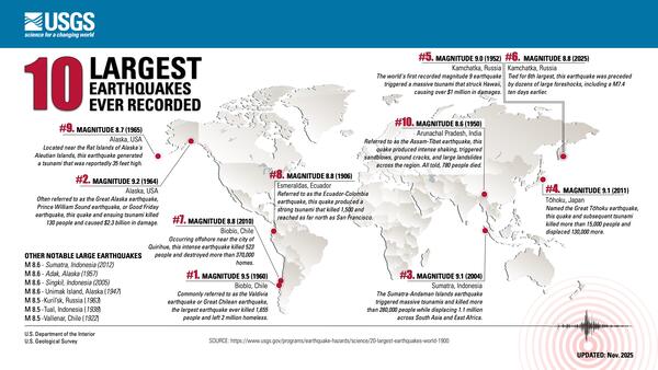
USGS releases aftershock forecast for M8.8 Russian Kamchatka Peninsula Earthquake
USGS releases aftershock forecast for M8.8 Russian Kamchatka Peninsula Earthquake
USGS Geologic Mapping Project Supports Critical Mineral Exploration, Enhances Public Safety in the Southeast
USGS Geologic Mapping Project Supports Critical Mineral Exploration, Enhances Public Safety in the Southeast
USGS Announces Recipients of Recent Earthquake Research Grants and Cooperative Agreements
USGS Announces Recipients of Recent Earthquake Research Grants and Cooperative Agreements
Publications
Rapid characterization of the 2025 Mw 8.8 Kamchatka, Russia earthquake Rapid characterization of the 2025 Mw 8.8 Kamchatka, Russia earthquake
The 29 July 2025 Mw 8.8 Kamchatka, Russia, earthquake was the sixth largest instrumentally recorded earthquake. This event was seismically well observed at regional and teleseismic distances, but publicly available near‐source data were sparse at the time of the event, presenting unique challenges for rapid source and impact characterization. The U.S. Geological Survey (USGS) National...
Capturing the uncertainty of seismicity observations in earthquake rate estimates: Implications for probabilistic seismic hazard analysis and the USGS National Seismic Hazard Model Capturing the uncertainty of seismicity observations in earthquake rate estimates: Implications for probabilistic seismic hazard analysis and the USGS National Seismic Hazard Model
The rate of earthquakes in a region is a fundamental input to Probabilistic Seismic Hazard Analysis. We present a Monte Carlo method for computing that rate from seismicity catalogs while including a range of data and analysis uncertainties. This method is applied to regions for which the b value is assumed to be spatially invariant. Each region is broken down into epochs for which each...
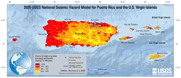
Using gridded seismicity to forecast the long-term spatial distribution of earthquakes for the 2025 Puerto Rico and U.S. Virgin Islands National Seismic Hazard Model Using gridded seismicity to forecast the long-term spatial distribution of earthquakes for the 2025 Puerto Rico and U.S. Virgin Islands National Seismic Hazard Model
Gridded (or background) seismicity models are a critical component of probabilistic seismic hazard assessments, accounting for off‐fault and smaller‐magnitude earthquakes. They are typically developed by declustering and spatially smoothing an earthquake catalog to estimate a long‐term seismicity rate that can be used to forecast future earthquakes. Here, we present new gridded...
Science

Earthquake Sequence Product
The USGS earthquake sequence product is a tool that identifies and describes earthquakes that are clustered in space and time as “sequences.” Its overarching goal is to provide simple contextual information regarding the spatial and temporal interconnection of earthquakes. The sequence product provides a description of a sequence, including information on the number and size of aftershocks, as...

Engineering and Risk
The well-known statement "Earthquakes don't kill people, buildings do" highlights the need to make our communities more earthquake resilient. The impact of earthquakes on public safety and the national economy can be reduced through improvement of the built environment to resist earthquake effects such as ground shaking. Extending natural hazards science to risk involves (1) conducting research to...

2025 Puerto Rico and U.S. Virgin Islands Long-term National Seismic Hazard Model
As we near full release of the 2025 Puerto Rico and U.S. Virgin Islands National Seismic Hazard Model, please check the table below for links to input model documentation, data releases, computer software, and review panel reports. Links will be updated as items are published.