
The USGS Glacier Project has conducted research beyond the Benchmark Glaciers, both past and present. This work has focused on infrastructure hazards, rapid glacier change, landscape destabilization, and glacier dynamics and processes not captured by the Benchmark Glacier network. These glaciers include Black Rapids, Kahiltna, Kennicott, Columbia, Hubbard, and Taku.
Return to Glaciers and Landscape Change
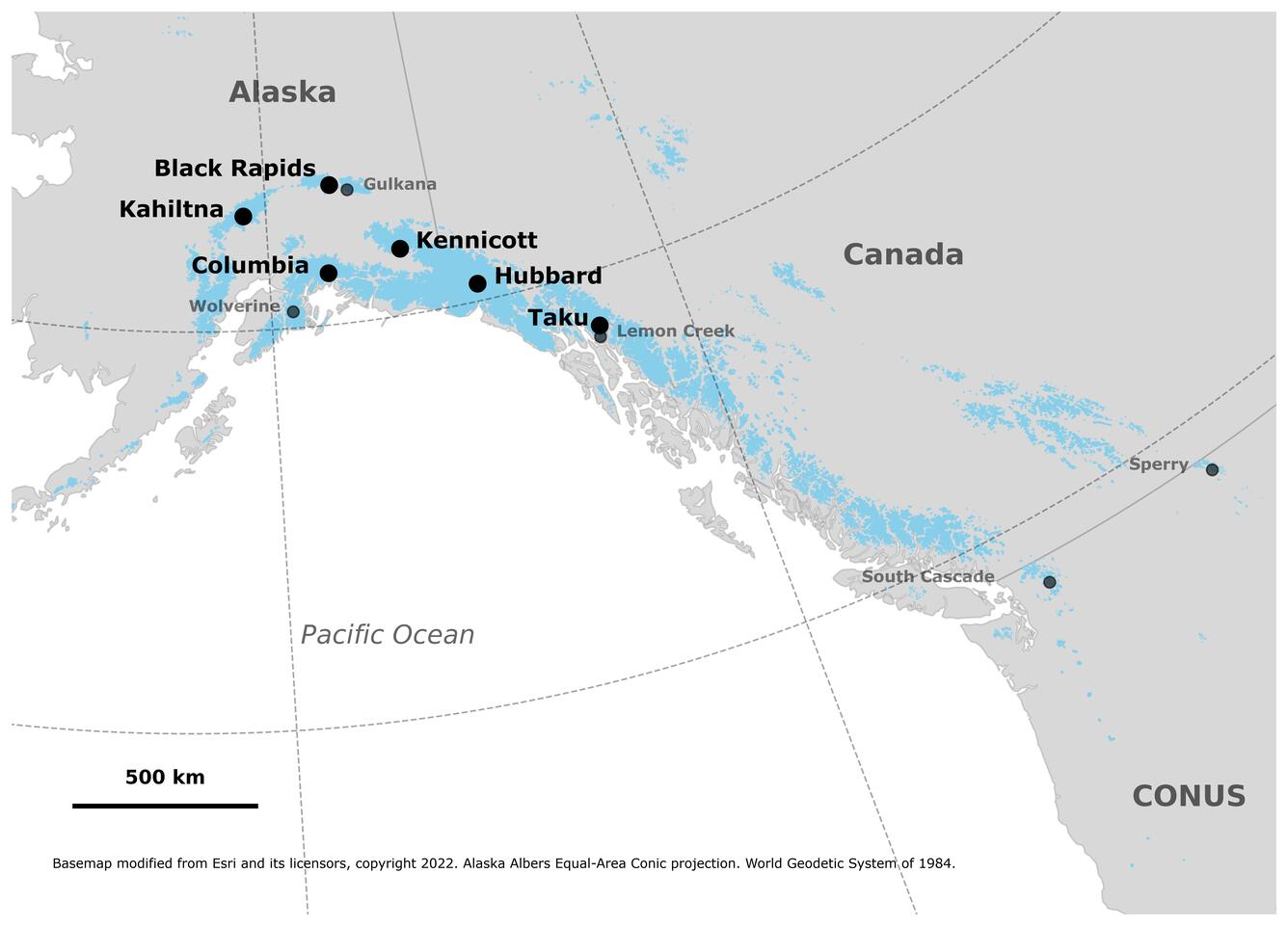
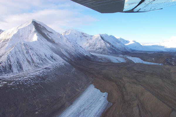
Black Rapids Glacier, Alaska
Black Rapids Glacier is a surge-type glacier that most recently surged in 1936–37 and is currently in its quiescent phase. While many glaciers in Alaska exhibit recurring surge behavior, Black Rapids is of particular interest because of its proximity to the trans-Alaska oil pipeline, making it a potential infrastructure hazard.
USGS studied Black Rapids Glacier from 1970 to 1992, collecting observations of mass balance, ice velocity, glacier surface altitude, and ice thickness. Ten sites on the glacier were monitored from 1972 to 1987, and three sites continued through 1992. More recently, the University of Alaska has carried on long-term study of this glacier.
On November 3, 2002, the magnitude 7.9 Denali Fault Earthquake triggered several massive landslides onto the glacier. Three rock fall events from the south wall covered approximately 13 km of the ablation area, or about 5% of the total glacier surface.
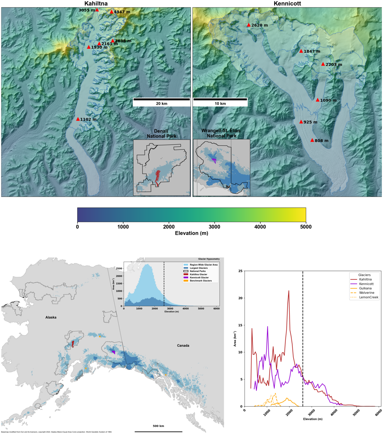
Kahiltna and Kennicott Glaciers, Alaska
The National Park Service (NPS) Inventory and Monitoring Program began quantifying glacier change on Kahiltna Glacier (Denali National Park and Preserve) in 1991 as part of the Long-term Ecological Monitoring (LTEM) program. During the proposal and project development, NPS scientists collaborated with glaciologists from USGS and the University of Alaska Fairbanks. An initial mass-balance measurement site was established near the elevation where annual melt and accumulation are approximately balanced (often called the Equilibrium Line Altitude or ELA). This site and others that have been added over time have been continuously monitored on a seasonal basis for snow accumulation and melt plus surface elevation changes.
Mass-balance measurements on Kennicott Glacier began in 2016 in recognition of the value in adding a comparable, highly visible, and highly visited glacier in the most heavily glaciated national park: Wrangell-St. Elias National Park and Preserve. Now, mass balance monitoring efforts on these two glaciers are currently performed in collaboration between the Central Alaska Network (part of the NPS Inventory and Monitoring Program) and the U.S. Geological Survey Benchmark Glacier Program.
These two large glaciers have complex geometries and extensive areas at higher elevations. The mass balance processes are different at these high elevations than at those measured by the USGS Benchmark Glacier Project or from those typically measured globally. Collaboration between USGS and NPS glacier research teams aims to broadly improve the monitoring and research on Kahiltna and Kennicott Glaciers, in part by combining the NPS commitment to monitoring these large glaciers with the workflow and skillsets within the USGS Benchmark Glacier Project. Ultimately these efforts will produce annual glacier-wide mass balance estimates that are corrected to the seasonal mass maximum and minimum and calibrated with geodetic, satellite-measured volume change. Field-based mass balance point measurements are already enhancing our understanding of glacier processes at higher elevations—which is particularly critical to understand how larger glaciers in the Alaska Region are changing.
Point mass balance measurements from Kahiltna and Kennicott Glaciers are available through an official USGS data release.

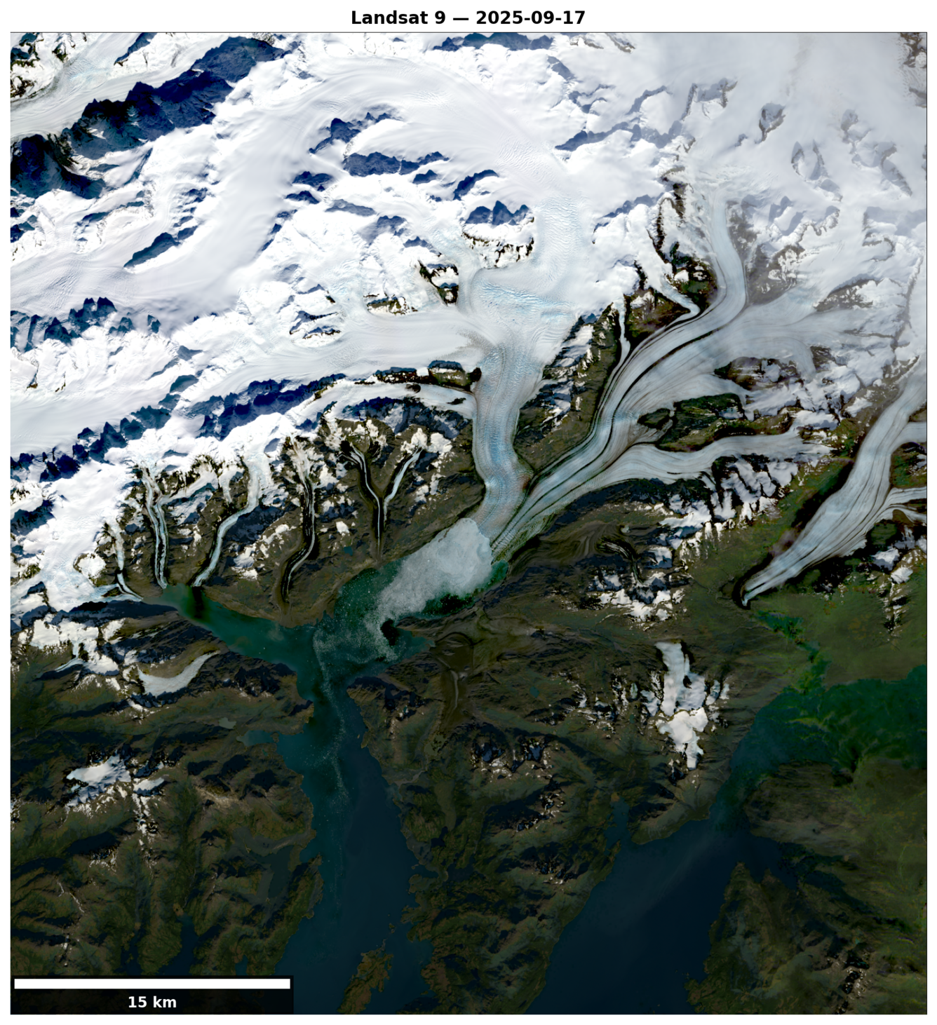
Columbia Glacier, Alaska
Columbia Glacier is a large (approx. 1000 square kilometers), multi-branched tidewater glacier in south-central Alaska, flowing south out of the Chugach Mountains to Prince William Sound. Prior to 1980, the 66 km long glacier had a history of stability, with only minor and short-lived advances or retreats. From 1957 to 1974, the surface elevation of the lower glacier was stable to within a few meters, suggesting the glacier was in approximate climatic equilibrium for at least two decades.
Mark Meier, Austin Post, Al Rasmussen, and Bill Sikonia (all USGS at the time) famously predicted that Columbia glacier would retreat in a 1979 publication. Indeed, the stability ended in the early 1980s, and Columbia Glacier began a rapid and sustained retreat. The intensive studies by the USGS in the late 1970s and 1980s were written up in dozens of Journal articles and USGS Professional Papers, ultimately leading to our modern understanding of tidewater glacier dynamics. The terminus retreated far enough back to split into two branches by 2012, the Post Branch and the Main Branch. By late 2025 the main branch had retreated over 26 km since 1980. While climate fluctuations likely triggered the initial retreat, the ongoing recession has been driven primarily by the mechanics of the calving glacier cycle, largely independent of short-term climate variability.
Previous research at Columbia Glacier focused on understanding calving dynamics, estimating ice thickness, and calculating mass balance. Today, the glacier continues to serve as a striking example of the rapid rates of retreat and mass loss that tidewater glaciers can undergo compared to their land-terminating counterparts.
Hubbard Glacier, Alaska
Hubbard Glacier is the largest tidewater glacier in North America. Unlike the vast majority of glaciers, which have thinned and retreated over the past century, Hubbard has been thickening and advancing toward the Gulf of Alaska since it was first mapped by the International Boundary Commission in 1895. This atypical behavior is a compelling example of the calving glacier cycle, in which terminus advance and retreat are controlled more by the mechanics of ice calving than by climate fluctuations alone.
If Hubbard Glacier continues its advance, it will eventually close the seaward entrance to Russell Fiord, creating the largest glacier-dammed lake in North American recorded history — a scenario that has already occurred twice. In 1986, the advancing terminus dammed Russell Fiord for five months, raising the lake level by 84 feet before erosion carved a new outlet and restored the fiord. In 2002, a similar event dammed the fiord for approximately two and a half months, raising Russell Lake by 61 feet. The 2002 event was recorded by a stage recorder installed on June 23 at Marble Point, located about 4.5 miles southeast of the closure site.
Taku Glacier, Alaska
Taku Glacier is a tidewater glacier in southeast Alaska and the main outlet glacier of the Juneau Icefield. Among the 20 largest glaciers in the Alaska region, Taku spans from sea level to 2,130 meters in elevation. Its relatively high median elevation allows the glacier to accumulate more mass through snowfall than neighboring glaciers, which drove a sustained advance from the late 19th century through much of the 20th century.
Mass balance measurements on Taku Glacier began in 1946 under the Juneau Icefield Research Program, established to study and explain the glacier's ongoing advance. Over the following decades, additional research by the University of Alaska and USGS deepened understanding of the advance and provided estimates of ice thickness. Together, this body of work has improved our understanding of how glacier mass balance correlates across mountain ranges, how factors such as hypsometry influence long-term glacier change, and feedback mechanisms accelerating mass loss.
Since 2013, however, Taku Glacier has experienced a significant decline in mass balance, leading to the onset of retreat in 2015 — marking the end of its century-long advance. Previous research by the USGS on Taku Glacier leveraged the workflow of the Benchmark Glacier Project to homogenize glacier-wide estimates of annual glacier mass balance. Mass balance measurements continue to be collected by the Juneau Icefield Research Program today, constituting the longest glacier mass balance record in North America.


Glaciers and Landscape Change
The USGS Glacier Project has conducted research beyond the Benchmark Glaciers, both past and present. This work has focused on infrastructure hazards, rapid glacier change, landscape destabilization, and glacier dynamics and processes not captured by the Benchmark Glacier network. These glaciers include Black Rapids, Kahiltna, Kennicott, Columbia, Hubbard, and Taku.
Return to Glaciers and Landscape Change
Black Rapids Glacier, Alaska
Black Rapids Glacier is a surge-type glacier that most recently surged in 1936–37 and is currently in its quiescent phase. While many glaciers in Alaska exhibit recurring surge behavior, Black Rapids is of particular interest because of its proximity to the trans-Alaska oil pipeline, making it a potential infrastructure hazard.
USGS studied Black Rapids Glacier from 1970 to 1992, collecting observations of mass balance, ice velocity, glacier surface altitude, and ice thickness. Ten sites on the glacier were monitored from 1972 to 1987, and three sites continued through 1992. More recently, the University of Alaska has carried on long-term study of this glacier.
On November 3, 2002, the magnitude 7.9 Denali Fault Earthquake triggered several massive landslides onto the glacier. Three rock fall events from the south wall covered approximately 13 km of the ablation area, or about 5% of the total glacier surface.
Kahiltna and Kennicott Glaciers, Alaska
The National Park Service (NPS) Inventory and Monitoring Program began quantifying glacier change on Kahiltna Glacier (Denali National Park and Preserve) in 1991 as part of the Long-term Ecological Monitoring (LTEM) program. During the proposal and project development, NPS scientists collaborated with glaciologists from USGS and the University of Alaska Fairbanks. An initial mass-balance measurement site was established near the elevation where annual melt and accumulation are approximately balanced (often called the Equilibrium Line Altitude or ELA). This site and others that have been added over time have been continuously monitored on a seasonal basis for snow accumulation and melt plus surface elevation changes.
Mass-balance measurements on Kennicott Glacier began in 2016 in recognition of the value in adding a comparable, highly visible, and highly visited glacier in the most heavily glaciated national park: Wrangell-St. Elias National Park and Preserve. Now, mass balance monitoring efforts on these two glaciers are currently performed in collaboration between the Central Alaska Network (part of the NPS Inventory and Monitoring Program) and the U.S. Geological Survey Benchmark Glacier Program.
These two large glaciers have complex geometries and extensive areas at higher elevations. The mass balance processes are different at these high elevations than at those measured by the USGS Benchmark Glacier Project or from those typically measured globally. Collaboration between USGS and NPS glacier research teams aims to broadly improve the monitoring and research on Kahiltna and Kennicott Glaciers, in part by combining the NPS commitment to monitoring these large glaciers with the workflow and skillsets within the USGS Benchmark Glacier Project. Ultimately these efforts will produce annual glacier-wide mass balance estimates that are corrected to the seasonal mass maximum and minimum and calibrated with geodetic, satellite-measured volume change. Field-based mass balance point measurements are already enhancing our understanding of glacier processes at higher elevations—which is particularly critical to understand how larger glaciers in the Alaska Region are changing.
Point mass balance measurements from Kahiltna and Kennicott Glaciers are available through an official USGS data release.
Columbia Glacier, Alaska
Columbia Glacier is a large (approx. 1000 square kilometers), multi-branched tidewater glacier in south-central Alaska, flowing south out of the Chugach Mountains to Prince William Sound. Prior to 1980, the 66 km long glacier had a history of stability, with only minor and short-lived advances or retreats. From 1957 to 1974, the surface elevation of the lower glacier was stable to within a few meters, suggesting the glacier was in approximate climatic equilibrium for at least two decades.
Mark Meier, Austin Post, Al Rasmussen, and Bill Sikonia (all USGS at the time) famously predicted that Columbia glacier would retreat in a 1979 publication. Indeed, the stability ended in the early 1980s, and Columbia Glacier began a rapid and sustained retreat. The intensive studies by the USGS in the late 1970s and 1980s were written up in dozens of Journal articles and USGS Professional Papers, ultimately leading to our modern understanding of tidewater glacier dynamics. The terminus retreated far enough back to split into two branches by 2012, the Post Branch and the Main Branch. By late 2025 the main branch had retreated over 26 km since 1980. While climate fluctuations likely triggered the initial retreat, the ongoing recession has been driven primarily by the mechanics of the calving glacier cycle, largely independent of short-term climate variability.
Previous research at Columbia Glacier focused on understanding calving dynamics, estimating ice thickness, and calculating mass balance. Today, the glacier continues to serve as a striking example of the rapid rates of retreat and mass loss that tidewater glaciers can undergo compared to their land-terminating counterparts.
Hubbard Glacier, Alaska
Hubbard Glacier is the largest tidewater glacier in North America. Unlike the vast majority of glaciers, which have thinned and retreated over the past century, Hubbard has been thickening and advancing toward the Gulf of Alaska since it was first mapped by the International Boundary Commission in 1895. This atypical behavior is a compelling example of the calving glacier cycle, in which terminus advance and retreat are controlled more by the mechanics of ice calving than by climate fluctuations alone.
If Hubbard Glacier continues its advance, it will eventually close the seaward entrance to Russell Fiord, creating the largest glacier-dammed lake in North American recorded history — a scenario that has already occurred twice. In 1986, the advancing terminus dammed Russell Fiord for five months, raising the lake level by 84 feet before erosion carved a new outlet and restored the fiord. In 2002, a similar event dammed the fiord for approximately two and a half months, raising Russell Lake by 61 feet. The 2002 event was recorded by a stage recorder installed on June 23 at Marble Point, located about 4.5 miles southeast of the closure site.
Taku Glacier, Alaska
Taku Glacier is a tidewater glacier in southeast Alaska and the main outlet glacier of the Juneau Icefield. Among the 20 largest glaciers in the Alaska region, Taku spans from sea level to 2,130 meters in elevation. Its relatively high median elevation allows the glacier to accumulate more mass through snowfall than neighboring glaciers, which drove a sustained advance from the late 19th century through much of the 20th century.
Mass balance measurements on Taku Glacier began in 1946 under the Juneau Icefield Research Program, established to study and explain the glacier's ongoing advance. Over the following decades, additional research by the University of Alaska and USGS deepened understanding of the advance and provided estimates of ice thickness. Together, this body of work has improved our understanding of how glacier mass balance correlates across mountain ranges, how factors such as hypsometry influence long-term glacier change, and feedback mechanisms accelerating mass loss.
Since 2013, however, Taku Glacier has experienced a significant decline in mass balance, leading to the onset of retreat in 2015 — marking the end of its century-long advance. Previous research by the USGS on Taku Glacier leveraged the workflow of the Benchmark Glacier Project to homogenize glacier-wide estimates of annual glacier mass balance. Mass balance measurements continue to be collected by the Juneau Icefield Research Program today, constituting the longest glacier mass balance record in North America.