
Hurricane Melissa, a category 5 storm, made landfall on October 28, 2025, near the border of Westmoreland and St. Elizabeth Parishes, southwestern Jamaica. The storm brought heavy rainfall, strong winds, and flooding to much of the Caribbean.
In Jamaica, intense rainfall on steep mountainous terrain raised concern about potential landslides.
This landslide event page serves as an event summary to communicate timely science information to multiple audiences. This information includes what is currently understood about the event and ongoing activities of the USGS.
What we are doing
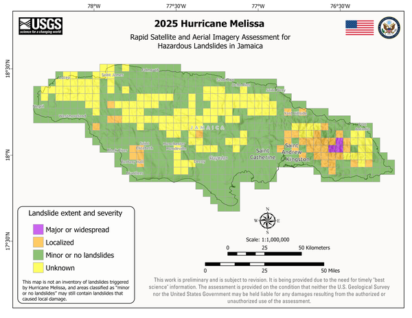
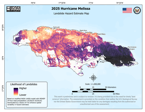
The U.S. Geological Survey (USGS) is analyzing satellite and aerial imagery to determine the general location and severity of landslides in Jamaica associated with Hurricane Melissa. This effort provides landslide situational awareness that supports the U.S. Government’s response and recovery efforts in these mountainous areas.
How to stay safe
- Landslides can still happen for the next few days to weeks, especially with more rain. Listen to national and NOAA weather alerts. Follow emergency messages from local authorities.
- Pay attention to the landslide warning signs. Watch for new cracks forming on the ground, leaning trees, new springs, or falling rocks.
- Do not try to clear landslides that are blocking roads without consulting a professional geologist or engineer. Removing material may remobilize the landslide, bringing more material down the hillside. Downed power lines or other hazards may be hidden under the landslide deposit.
- If a landslide impacted your home, or you see signs of a landslide, contact your local emergency services. Local officials are best able to assess potential danger. If the danger is not immediate, seek guidance from a qualified professional engineering geologist or civil engineer.
Learn More About Landslide Safety
Learn More About Landslide Preparedness
Landslide Assessments
The following USGS provisional data releases are available:
- Preliminary Landslide Hazard Estimate Maps—2025 Hurricane Melissa Landslide Emergency Response (for Jamaica and southwest Haiti)
- Rapid Imagery Assessment for Hazardous Landslides in Jamaica—2025 Hurricane Melissa Emergency Response
More Information
Learn more about the Department of State's response.
High-resolution Hurricane Melissa aerial imagery from National Oceanic and Atmospheric Administration (NOAA). Selected areas available for viewing.
Learn more about landslides in Jamaica from the Office of Disaster Preparedness and Emergency Management.
Landslide susceptibility maps from Jamaica's Division of Mines and Geology
Learn more about landslide preparedness.
Learn more about the Landslide Hazards Program.
Learn more about USGS Landslide Response.
References
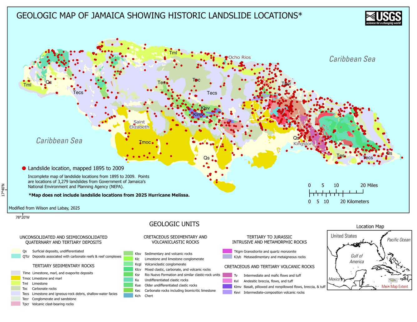
Wilson, F.H., and Labay, K.A., 2025, Data release for the geologic map of the Greater Antilles and Virgin Islands: U.S. Geological Survey data release, https://doi.org/10.5066/P13X7BHY.
| Disclaimer: This information is preliminary or provisional and is subject to revision. It is being provided to meet the need for timely science to assess ongoing hazards. The information has not received final approval by the U.S. Geological Survey (USGS) and is provided on the condition that neither the USGS nor the U.S. Government shall be held liable for any damages resulting from the authorized or unauthorized use of the information. |
Hurricane Melissa, a category 5 storm, made landfall on October 28, 2025, near the border of Westmoreland and St. Elizabeth Parishes, southwestern Jamaica. The storm brought heavy rainfall, strong winds, and flooding to much of the Caribbean.
In Jamaica, intense rainfall on steep mountainous terrain raised concern about potential landslides.
This landslide event page serves as an event summary to communicate timely science information to multiple audiences. This information includes what is currently understood about the event and ongoing activities of the USGS.
What we are doing
The U.S. Geological Survey (USGS) is analyzing satellite and aerial imagery to determine the general location and severity of landslides in Jamaica associated with Hurricane Melissa. This effort provides landslide situational awareness that supports the U.S. Government’s response and recovery efforts in these mountainous areas.
How to stay safe
- Landslides can still happen for the next few days to weeks, especially with more rain. Listen to national and NOAA weather alerts. Follow emergency messages from local authorities.
- Pay attention to the landslide warning signs. Watch for new cracks forming on the ground, leaning trees, new springs, or falling rocks.
- Do not try to clear landslides that are blocking roads without consulting a professional geologist or engineer. Removing material may remobilize the landslide, bringing more material down the hillside. Downed power lines or other hazards may be hidden under the landslide deposit.
- If a landslide impacted your home, or you see signs of a landslide, contact your local emergency services. Local officials are best able to assess potential danger. If the danger is not immediate, seek guidance from a qualified professional engineering geologist or civil engineer.
Learn More About Landslide Safety
Learn More About Landslide Preparedness
Landslide Assessments
The following USGS provisional data releases are available:
- Preliminary Landslide Hazard Estimate Maps—2025 Hurricane Melissa Landslide Emergency Response (for Jamaica and southwest Haiti)
- Rapid Imagery Assessment for Hazardous Landslides in Jamaica—2025 Hurricane Melissa Emergency Response
More Information
Learn more about the Department of State's response.
High-resolution Hurricane Melissa aerial imagery from National Oceanic and Atmospheric Administration (NOAA). Selected areas available for viewing.
Learn more about landslides in Jamaica from the Office of Disaster Preparedness and Emergency Management.
Landslide susceptibility maps from Jamaica's Division of Mines and Geology
Learn more about landslide preparedness.
Learn more about the Landslide Hazards Program.
Learn more about USGS Landslide Response.
References
Wilson, F.H., and Labay, K.A., 2025, Data release for the geologic map of the Greater Antilles and Virgin Islands: U.S. Geological Survey data release, https://doi.org/10.5066/P13X7BHY.
| Disclaimer: This information is preliminary or provisional and is subject to revision. It is being provided to meet the need for timely science to assess ongoing hazards. The information has not received final approval by the U.S. Geological Survey (USGS) and is provided on the condition that neither the USGS nor the U.S. Government shall be held liable for any damages resulting from the authorized or unauthorized use of the information. |