
Cross-polarized light photomicrograph of minerals in drill core samples from the Local Boy deposit, Duluth Complex, Minnesota. The number in the upper right hand corner is the drill core number.
Images
Mineral Resources Program images.
Filter Total Items: 268

Local Boy Drill Core - 10089 (microscope image)
Cross-polarized light photomicrograph of minerals in drill core samples from the Local Boy deposit, Duluth Complex, Minnesota. The number in the upper right hand corner is the drill core number.

Mesaba Deposit Drill Core (microscope image)
Cross-polarized light photomicrograph of minerals in drill core samples from the Mesaba copper-nickel deposit, Duluth Complex, Minnesota. The number in the upper right hand corner is the drill core number.
Cross-polarized light photomicrograph of minerals in drill core samples from the Mesaba copper-nickel deposit, Duluth Complex, Minnesota. The number in the upper right hand corner is the drill core number.

Axinite
This is a sample of axinite with iron, making it ferroaxinite. Axinite is primarily used as a collectors mineral.
Sample provided by Carlin Green, USGS. Sample originated from Puiva Mount, Russia, and is 3.0cm in size.
This is a sample of axinite with iron, making it ferroaxinite. Axinite is primarily used as a collectors mineral.
Sample provided by Carlin Green, USGS. Sample originated from Puiva Mount, Russia, and is 3.0cm in size.

Elbaite
Elbaite is one of the best-known members of the tourmaline mineral family, particularly for its high-quality gemstones. Read more about the tourmaline mineral family here.
Elbaite is one of the best-known members of the tourmaline mineral family, particularly for its high-quality gemstones. Read more about the tourmaline mineral family here.

Epidote and Quartz
Epidote is a silicate mineral used mostly as a semiprecious gemstone.
Sample provided by Carlin Green, USGS. Sample originated from Prince of Wales Island, Alaska, and is 6.0cm in size.
Epidote is a silicate mineral used mostly as a semiprecious gemstone.
Sample provided by Carlin Green, USGS. Sample originated from Prince of Wales Island, Alaska, and is 6.0cm in size.

Sample of Cerussite
This sample is of the mineral cerussite, once an important source of lead for paints and pigments. With the phasing out of lead-based paints, cerussite is now mostly valued as a collectors mineral.
Sample provided by Carlin Green, USGS. Sample originated from Mibladen, Morocco, and is 5.6cm in size.

Slag - Calumet Region (microscope image)
Scanning Electron Microscope backscatter image of legacy steelmaking slag from the Calumet region, Chicago, Illinois, showing silicate minerals, some of which may have acid-neutralizing potential.
Scanning Electron Microscope backscatter image of legacy steelmaking slag from the Calumet region, Chicago, Illinois, showing silicate minerals, some of which may have acid-neutralizing potential.

Global Copper Map_0_0.jpg
Map showing sediment-hosted copper and porphyry copper deposits across the world.
Map showing sediment-hosted copper and porphyry copper deposits across the world.

Eureka Graben, Silverton caldera complex, CO
USGS scientist David Fey walking through the Eureka Graben in the Silverton caldera complex.
USGS scientist David Fey walking through the Eureka Graben in the Silverton caldera complex.
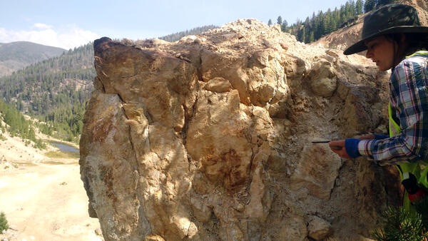
Geologist conducting field work at Yellow Pine/Stibnite mining area, central Idaho
Geologist conducting field work at Yellow Pine/Stibnite mining area, central IdahoUSGS geologist Niki Wintzer conducting field work at Yellow Pine/Stibnite gold-antimony-tungsten mining area in central Idaho.
Geologist conducting field work at Yellow Pine/Stibnite mining area, central Idaho
Geologist conducting field work at Yellow Pine/Stibnite mining area, central IdahoUSGS geologist Niki Wintzer conducting field work at Yellow Pine/Stibnite gold-antimony-tungsten mining area in central Idaho.
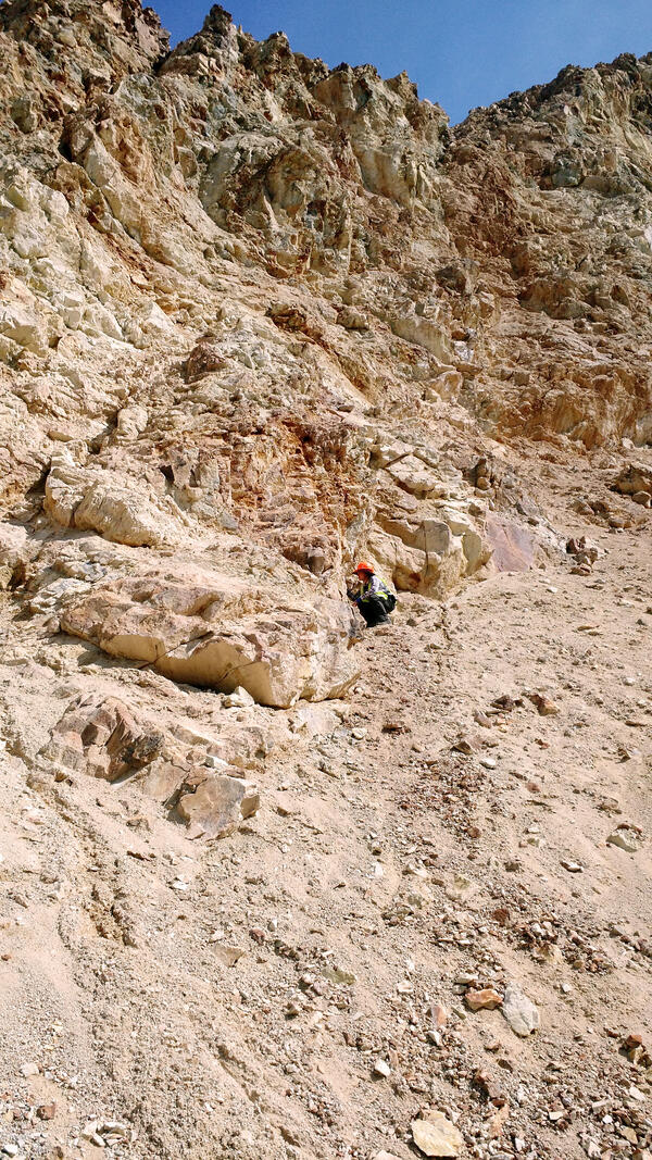
Geologist conducting field work at the gold-antimony-tungsten mining area
Geologist conducting field work at the gold-antimony-tungsten mining areaUSGS geologist Niki Wintzer conducting field work at Yellow Pine/Stibnite gold-antimony-tungsten mining area in central Idaho.
Geologist conducting field work at the gold-antimony-tungsten mining area
Geologist conducting field work at the gold-antimony-tungsten mining areaUSGS geologist Niki Wintzer conducting field work at Yellow Pine/Stibnite gold-antimony-tungsten mining area in central Idaho.
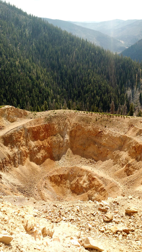
An open pit within the gold-antimony-tungsten mining area
An open pit within the gold-antimony-tungsten mining areaAn open pit within the Yellow Pine/Stibnite gold-antimony-tungsten mining area in central Idaho.
An open pit within the gold-antimony-tungsten mining area
An open pit within the gold-antimony-tungsten mining areaAn open pit within the Yellow Pine/Stibnite gold-antimony-tungsten mining area in central Idaho.

Heavy mineral sands, Folly Beach, South Carolina
Layered deposit of unconsolidated heavy mineral sands along the shores of Folly Beach, South Carolina.
Layered deposit of unconsolidated heavy mineral sands along the shores of Folly Beach, South Carolina.

Red Mountain near Silverton, Colorado
Intensely altered propylitic rocks (red and yellow) in the Red Mountain mining district, overprinting the regional, propylitically altered igneous rocks (grayish-green), peaks at top of image. View to west.
Intensely altered propylitic rocks (red and yellow) in the Red Mountain mining district, overprinting the regional, propylitically altered igneous rocks (grayish-green), peaks at top of image. View to west.

Geologist and Helicopter
Geologist doing field work in Alaska
Geologist doing field work in Alaska

Eudialyte and Bastnäsite Samples
Sample of eudialyte (pink) within layered vein consisting of quartz, albite, and sodic amphibole, Dora Bay, Alaska. Size of sample is 11 by 9 cm. Sample of coarse-grained, tabular bastnäsite within matrix of ferruginous dolomite, Birthday Claim, Mountain Pass, California. Photographs by Philip Verplanck, U.S. Geological Survey. SIR 2010-5070-J
Sample of eudialyte (pink) within layered vein consisting of quartz, albite, and sodic amphibole, Dora Bay, Alaska. Size of sample is 11 by 9 cm. Sample of coarse-grained, tabular bastnäsite within matrix of ferruginous dolomite, Birthday Claim, Mountain Pass, California. Photographs by Philip Verplanck, U.S. Geological Survey. SIR 2010-5070-J

Ahankashan Copper Gold
Aerial view looking into the center of the dome-shaped pluton.
Aerial view looking into the center of the dome-shaped pluton.

Low-level Helicopter Towing a Large Wire-Loop Contraption Hanging from a Cable
Low-level Helicopter Towing a Large Wire-Loop Contraption Hanging from a CableA low-level helicopter towing a large wire-loop contraption hanging from a cable is flying straight across an open field in Nebraska on a clear day.

Aerial Over Weka Dur Gold Deposit, Badakhshan
Aerial view over Weka Dur, Afghanistan’s largest known gold deposit, Badakhshan Province.
Aerial view over Weka Dur, Afghanistan’s largest known gold deposit, Badakhshan Province.

Low-level Helicopter Towing a Large Wire-Loop Contraption Hanging From a Cable
Low-level Helicopter Towing a Large Wire-Loop Contraption Hanging From a CableHelicopter towing a large, wire-loop contraption hanging from a cable is turning in air on a relatively clear day in Nebraska.
Low-level Helicopter Towing a Large Wire-Loop Contraption Hanging From a Cable
Low-level Helicopter Towing a Large Wire-Loop Contraption Hanging From a CableHelicopter towing a large, wire-loop contraption hanging from a cable is turning in air on a relatively clear day in Nebraska.

Redbeds Near Herat
Aerial view near Herat. Dark red iron stains hint that other minerals might be found.
Aerial view near Herat. Dark red iron stains hint that other minerals might be found.