
Our data, analysis tools, and analytical methods support satellite architecture studies, determine science mission requirements, inform international collaborations, and support investment decisions such as commercial data purchases.
ANALYSIS
The U.S. Geological Survey (USGS) plays a central role in understanding how Earth observation data supports the Nation’s science, safety, and decision‑making needs. Recent studies highlight the enormous economic value of the Landsat program, the growing demand for satellite data, and the importance of identifying user needs to guide future missions like Landsat 10.
USGS also works closely with federal partners to assess data gaps, support wildfire response, evaluate Earth observation systems, and inform national investments in satellite capabilities.
Together, these efforts ensure that critical Earth observation data continues to deliver benefits for agriculture, forestry, emergency response, and many other public services.
Program Highlights
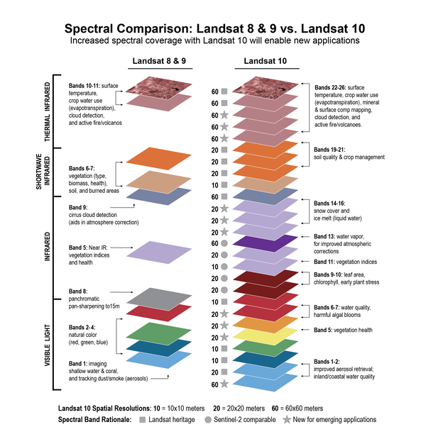
Identified User Needs-Driven Landsat 10 Mission Design
Challenge: The Landsat data user community has expanded significantly over the past five decades. A comprehensive understanding of user requirements, application workflows, and data demand trends is essential to inform the design and strategic planning of future Landsat mission architectures.
USGS Actions: Beginning in 2015, we launched a comprehensive, community‑wide user‑needs collection initiative, developed an analytical assessment framework, and supported the 2019 Landsat Architecture Study Team (AST). This effort produced the most extensive, data‑driven evaluation of user needs in the history of the Landsat program, analyzing more than 200 prospective Landsat 10 architecture options against over 350 distinct land‑imaging user requirements.
Impact: Our analysis identified specific mission design enhancements for Landsat 10 and generated recommendations grounded in quantitative user‑needs assessment.
Learn more about the Landsat 10 Mission.

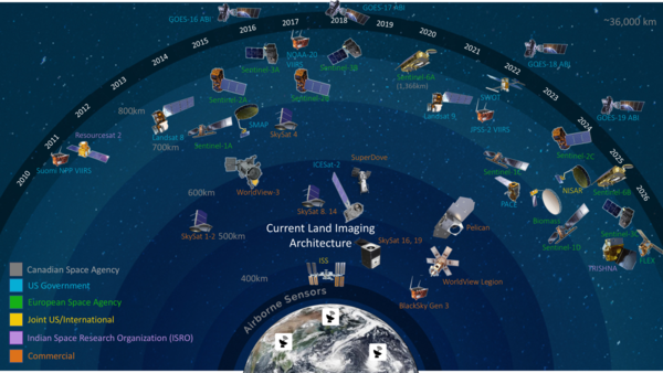
Assess National Land Imaging Data Acquisitions
Challenge: The Sustainable Land Imaging (SLI) partnership directs the USGS to lead cross-agency efforts to identify user-driven gaps in land imaging capabilities and support the procurement agreements to augment SLI capabilities. As such, we are charged with evaluating land imaging user needs against space-based land imaging capabilities to identify gaps.
USGS Actions: In 2021 we leveraged our database of 758 user needs and developed an innovative new tool to pinpoint strengths and weaknesses in the current architecture, modeling and evaluating over 100 different satellite systems.
Impact: We identified three specific commercial, space-based data acquisitions to supplement the existing land imaging architecture to meet needs.
Support USGEO Satellite Needs Working Group (SNWG)
Challenge: The U.S. Group on Earth Observation’s (USGEO) SNWG surveys federal agencies to identify what Earth observation data they need to fulfill their mission and communicate satellite Earth-observing needs to NASA and other space-based Earth observation providers.
USGS Actions: Biennially we collaborate with interagency partners to evaluate survey submissions to understand agency needs, discern gaps in the current Earth Observation (EO) program of record, and recommend potential solutions. National Land Imaging Program staff served on SNWG’s Solutions Applications Board to evaluate potential solutions based on several factors including scientific merit, impact, and feasibility.
Impact: We have supported 3 SNWG cycles resulting in over 29 solutions including the widely used Harmonized Landsat and Sentinel-2 product.
Learn more about the Satellite Needs Working Group (SNWG).
Support the NASA Senior Review with Satellite Data Usage
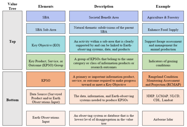
Challenge: The RCA-EO initiative is charged with providing clear, well-documented information on remote sensing data users, their applications, and dependencies to NASA’s Science Mission Directorate. The comprehensive reviews help steer NASA’s Senior Review on Earth science missions by ensuring the value and justifying the impact of these missions.
USGS Actions: Since 2017, USGS has consistently submitted user needs data and value trees to the NASA Earth Science Senior Review every three years. Leveraging our expertise in the USGS and DOI communities, we have provided more than 100 unique inputs, directly informing NASA’s decision-making process.
Impact: USGS delivers detailed, quantitative inputs that help NASA evaluate and prioritize mission utility, value, and latency. This information guides investment choices and demonstrates the practical benefits of Earth observation missions and data to decision makers.
Learn more about NASA Senior Reviews.
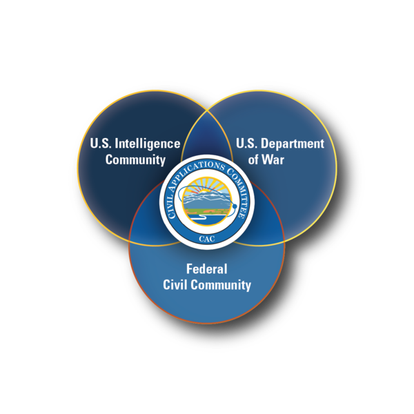
Assures Visibility to Civil User Needs
Challenge: The Civil Applications Committee (CAC) works to ensure that civil agencies can access and apply remote sensing data collected by military and intelligence sources. To support this mission, we are responsible for regularly providing a coordinated set of civil, land imaging user needs aligned with priority applications.
USGS Actions: Since 2020, we have conducted an annual collection of high resolution user needs across the civil community. This process produces an integrated and consistent set of requirements submitted to the intelligence community for consideration. To date, we have provided more than 220 civil application needs.
Impact: Our work helps ensure that civil agency requirements are incorporated into future intelligence community contracts. This enables scientific research by supporting appropriate data sharing and improving government efficiency through a unified, cost effective mechanism for accessing needed imagery.
Learn more about the Civil Applications Committee.
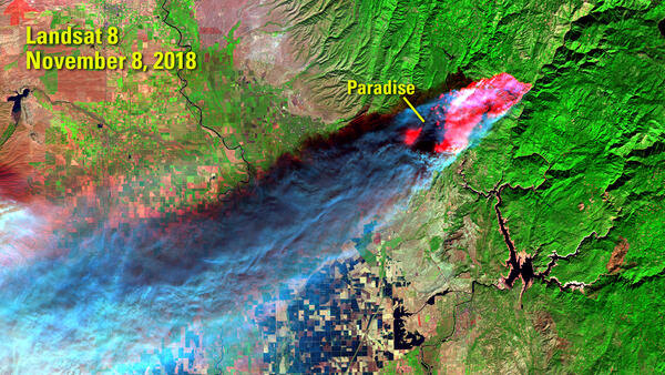
Assessing Wildland Fire Earth Observation Gaps
Challenge: Wildland fires have grown into a more serious and complex problem in recent years, causing increasingly severe damage. Professionals in this field rely on Earth observation data to understand the fire life cycle but data gaps limit comprehensive assessment.
USGS Actions: In 2022, we conducted a 6-month evaluation of gaps in Earth observation systems and data related to pre-, active-, and post-wildland fire activities interviewing 99 subject matter experts.
Impact: We identified 21 actionable recommendations addressing the gaps that would provide tangible, near-term benefits to stakeholders in the community. Learn more about USGS Wildland Fire Science.
Analyze User Needs for Sustainable Land Imaging Mission Alternatives Assessment Team (MAAT)
Challenge: In 2025, NASA’s Science Mission Directorate (SMD) stood up the MAAT as an independent body to advise NASA on options to be responsive to the President’s budget request for the Fiscal Year 2026 by assessing alternative Landsat 10 architectures. As such, we were charged with evaluating the impact of alternative architectures on land imaging user needs.
USGS Actions: Identified specific tradeoffs in various architectures in supporting the land imaging user community and maintaining Landsat user continuity.
Impact: Delivered performance evaluations of Landsat 10 architecture options to inform MAAT recommendation development. Learn more about the NASA SLI MAAT.
Lead USGEO’s Earth Observation Assessment
Challenge: The Earth Observation Assessment (EOA) evaluates the effectiveness of civil Earth observation systems in meeting federal objectives to guide investments and inform the National Plan for Civil Earth Observations.
USGS Actions: Since 2012 we have led 3 EOAs actively facilitating the assessment process, collecting data, and analyzing results. Most recently we conducted a 2-year study to evaluate the use of Earth Observation data in agricultural, forestry, and climate sectors. We documented federal government use of 1,450 data products using over 3,000 Earth observation data sources.
Impact: Our analysis highlighted how Earth observation data sources interconnect to bring societal benefits in agriculture, forestry, and climate. We documented over 20,000 data dependencies and provided a ranked list of the most impactful data sources to support these areas.
Learn more about the Earth Observation Assessment (EOA).