San Miguel Site Map, New Mexico Water Science Center
San Miguel Site Map, New Mexico Water Science CenterCanadian escarpment rising above the plains, northeastern San Miguel County, NMWSC

Official websites use .gov
A .gov website belongs to an official government organization in the United States.
Secure .gov websites use HTTPS
A lock () or https:// means you’ve safely connected to the .gov website. Share sensitive information only on official, secure websites.
Images described and linked on this webpage come from a wide variety of USGS science activities and presentations performed by USGS Science Center staff members in the Region 7: Upper Colorado Basin. A search tool is provided to narrow the number of image files shown.

Canadian escarpment rising above the plains, northeastern San Miguel County, NMWSC
Canadian escarpment rising above the plains, northeastern San Miguel County, NMWSC
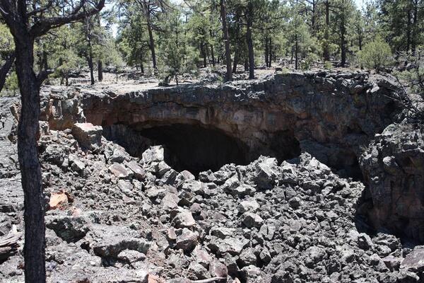
Opening of a large lava tube at El Malpais National Monument in western New Mexico and likely roost for bats, 2011.
Opening of a large lava tube at El Malpais National Monument in western New Mexico and likely roost for bats, 2011.

View from sandstone bluff overlooking extinct lava flows at El Malpais National Monument, New Mexico.
View from sandstone bluff overlooking extinct lava flows at El Malpais National Monument, New Mexico.

Elk in the Beartooth Mountains, Wyoming. The USGS and partners study the effects of climate change on the Greater Yellowstone Ecosystem.
Elk in the Beartooth Mountains, Wyoming. The USGS and partners study the effects of climate change on the Greater Yellowstone Ecosystem.

This is a false-color-composite satellite image of Great Salt Lake, Nov 2011. The vegetation appears red.
This is a false-color-composite satellite image of Great Salt Lake, Nov 2011. The vegetation appears red.

Measuring streamflow using ADCP, Fish Creek

Extensive, contiguous mortality of piñon pine, ponderosa pine, and Douglas-fir trees, killed in the first afternoon and evening of the 2011 Las Conchas Fire in the Jemez Mountains, New Mexico. Forest drought stress is highly correlated with mortality from poor growth, bark beetle outbreaks, and high-severity fire.
Extensive, contiguous mortality of piñon pine, ponderosa pine, and Douglas-fir trees, killed in the first afternoon and evening of the 2011 Las Conchas Fire in the Jemez Mountains, New Mexico. Forest drought stress is highly correlated with mortality from poor growth, bark beetle outbreaks, and high-severity fire.

Dry conditions at cattle water sources in western Colorado.
Dry conditions at cattle water sources in western Colorado.

Cattle walking across biological soil crusts in southeastern Utah.
Cattle walking across biological soil crusts in southeastern Utah.

Gagehouse at 06225500 Wind River near Crowheart WY right before it washed away.
Jul 01 2011; 13,900 ft3/s
Gagehouse at 06225500 Wind River near Crowheart WY right before it washed away.
Jul 01 2011; 13,900 ft3/s

USGS hydrographer Jerrod Wheeler (in cablecar) measures flood flows right before the gagehouse washes away.
06225500 Wind River near Crowheart, WY: Jul 01 2011; 13,900 ft3/s
USGS hydrographer Jerrod Wheeler (in cablecar) measures flood flows right before the gagehouse washes away.
06225500 Wind River near Crowheart, WY: Jul 01 2011; 13,900 ft3/s

High floodwaters partially submerge a USGS streamgaging station in Slater Fork, CO.
High floodwaters partially submerge a USGS streamgaging station in Slater Fork, CO.

High floodwaters on the Elk River upstream of Routt County Road 42 near Milner, CO.
High floodwaters on the Elk River upstream of Routt County Road 42 near Milner, CO.

High floodwaters on the Elk River upstream of Routt County Road 42 near Milner, CO
High floodwaters on the Elk River upstream of Routt County Road 42 near Milner, CO

Floodwaters partially submerge a USGS streamgage station near Slater, CO.
Floodwaters partially submerge a USGS streamgage station near Slater, CO.

A roadway is broken down due to high streamflow near Slater, CO. A USGS streamgage can be seen next to the road.
A roadway is broken down due to high streamflow near Slater, CO. A USGS streamgage can be seen next to the road.

Water flowing through the Great Salt Lake breach in 2011, when lake levels were high due to above average snowfall in the Wasatch and Uinta Mountains. The Great Salt Lake breach is an area that allows water to travel between the southern and northern parts of the lake.
Water flowing through the Great Salt Lake breach in 2011, when lake levels were high due to above average snowfall in the Wasatch and Uinta Mountains. The Great Salt Lake breach is an area that allows water to travel between the southern and northern parts of the lake.

Collecting a groundwater sample using a mobile laboratory at Jackson Hole Airport
Collecting a groundwater sample using a mobile laboratory at Jackson Hole Airport

View of Jackson Hole Airport and the Teton Range
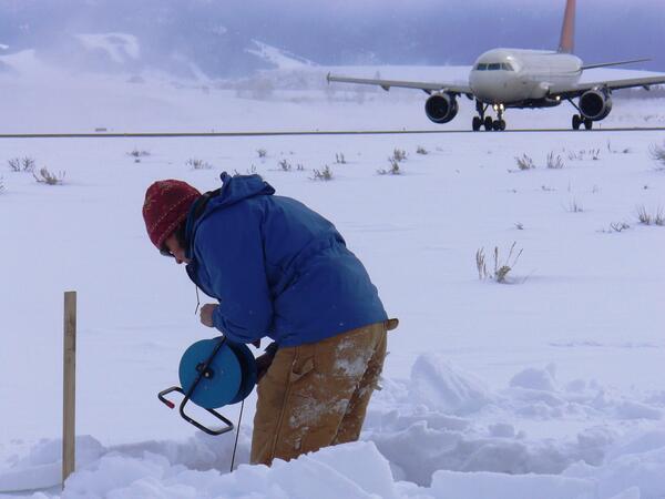
Taking a water-level measurement in a monitoring well at Jackson Hole Airport.
Taking a water-level measurement in a monitoring well at Jackson Hole Airport.

Lamar Valley, Yellowstone National Park.