
USGS Science Collaboration Portal for the Colorado River Basin
Collaboration platform that brings together science, data, and mapping and analytical tools from across the basin
Collaboration platform that brings together science, data, and mapping and analytical tools from across the basin
Colorado River Basin Actionable and Strategic Integrated Science and Technology (ASIST) Initiative
Fostering Innovative Interdisciplinary Science for Characterizing and Adapting to Long-term Drought
Fostering Innovative Interdisciplinary Science for Characterizing and Adapting to Long-term Drought
Colorado River Basin Drought and the 2023 Water Year
Geonarrative presentation comparing 2023 conditions to the long-term drought in the Colorado River Basin
Geonarrative presentation comparing 2023 conditions to the long-term drought in the Colorado River Basin
Great Salt Lake Data and Reports by the USGS
Learn about Water Quantity and Quality and Aquatic Ecology of this National Treasure
Learn about Water Quantity and Quality and Aquatic Ecology of this National Treasure
Colorado River Basin Studies in Utah
Learn about Surface Water, Groundwater Quantities and Quality and Artificial Recharge of Groundwater in the Colorado River Basin in Utah
Learn about Surface Water, Groundwater Quantities and Quality and Artificial Recharge of Groundwater in the Colorado River Basin in Utah
Streamflow in the Upper Rio Grande Basin
USGS Analyses of the Effects of Potential Future Climate Conditions on Streamflows in the Upper Rio Grande Basin
USGS Analyses of the Effects of Potential Future Climate Conditions on Streamflows in the Upper Rio Grande Basin
Next Generation Water Observing System (NGWOS) Study: Upper Colorado River Basin
The USGS NGWOS Program Provides Innovative, High-fidelity, Real-time Data and Insightful Analyses about Water Quantity, Quality, and Use in Selected Watersheds across the U.S.
The USGS NGWOS Program Provides Innovative, High-fidelity, Real-time Data and Insightful Analyses about Water Quantity, Quality, and Use in Selected Watersheds across the U.S.
Rocky Mountain Region
USGS Region 7 Staff support and advise USGS Science Centers that provide numerous stakeholders with vital information about spatial distribution and temporal trends in critical minerals, energy resources, geology, water resources, native plants and wildlife, and hazards posed by earthquakes and landslides in Colorado, New Mexico, Utah, Wyoming and beyond.
USGS Region 7: Upper Colorado Basin (Rocky Mountain)
USGS Region 7: Upper Colorado Basin (Rocky Mountain)

Map Showing USGS/DOI Unified Region 7 and adjoining Regions
Key USGS Region 7 Contacts
Key USGS Region 7 Contacts
Additional Information about USGS Region 7
Additional Information about USGS Region 7
News
FORT Updates: From Plains to Peaks - Vol. 4 | Issue 2
FORT Updates: From Plains to Peaks - Vol. 4 | Issue 2
New Nationwide Tool Helps Answer: Do We Have Enough Water?
New Nationwide Tool Helps Answer: Do We Have Enough Water?
FORT Updates: From Plains to Peaks - Vol. 4 | Issue 1
FORT Updates: From Plains to Peaks - Vol. 4 | Issue 1
Publications
Coal beneath Federal lands in the United States—Mines, reserves, and resources Coal beneath Federal lands in the United States—Mines, reserves, and resources
The U.S. Geological Survey (USGS) compiled a list of coal mines and tabulated the coal reserves and available coal resources beneath Federal lands in the conterminous United States. Coal resources beneath Federal lands in Alaska are also discussed in this report. In 2024, the 34 coal mines on Federal lands produced more than 261 million short tons of coal. Surface mining is used at 23 of...
Predicting reach-scale macroinvertebrate community changes due to declining flows in an aridland river Predicting reach-scale macroinvertebrate community changes due to declining flows in an aridland river
Understanding the connection between streamflow and macroinvertebrate community structure is critical for managing river ecosystems under scenarios of change caused by human activities and drought. Streamflow influences physical habitat characteristics, including depth, water velocity, and substrate composition, which structure macroinvertebrate communities. Although strong empirical...
Beaver dam analogs as nature-based solutions to mitigate snowpack loss in northern New Mexico Beaver dam analogs as nature-based solutions to mitigate snowpack loss in northern New Mexico
Reductions in snow have left many streams in northern New Mexico dry or with very low flows during the summer. Base flow, defined as the contribution of groundwater to streamflow, can sustain streamflow during the summer and during drought conditions. Beaver dam analogs can be used to “slow the flow,” or increase the infiltration of rain-based runoff to replenish shallow groundwater...
Science
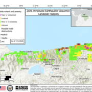
2026 Venezuela Sequence Earthquake-Triggered Landslide Hazards
On Wednesday, June 24th, 2026, a pair of earthquakes of Magnitude 7.2 and Magnitude 7.5 occurred in northern Venezuela, west of Caracas. The U.S. Geological Survey (USGS) Ground Failure product estimated that landslides triggered by this earthquake would likely be significant in number and/or spatial extent. This landslide event page serves to communicate timely science information to our partners...

Modernized Breeding Bird Survey Portal
The North American Breeding Bird Survey (BBS) Portal is a modern information system that enables volunteer observers and regional coordinators to manage survey routes, enter field data, and coordinate route assignments online. The portal replaces legacy paper-based and outdated digital workflows with a streamlined interface built for the BBS community. Observers can view their assigned routes...

Water Quality
The USGS, in partnership with multiple other groups, is learning about water-quality conditions across time and space in terminal lakes across the Great Basin. This effort is part of the Saline Lake Ecosystems Integrated Water Availability Assessment.