



Collecting sample in tall grass at Kane Springs, San Juan County, Utah, Fall 2015.
Images
Images described and linked on this webpage come from a wide variety of USGS science activities and presentations performed by USGS Science Center staff members in the Region 7: Upper Colorado Basin. A search tool is provided to narrow the number of image files shown.
Filter Total Items: 554

Kane Springs, San Juan County, Utah Fall 2015
Collecting sample in tall grass at Kane Springs, San Juan County, Utah, Fall 2015.

South Salt Wash, Emery County, Utah, Fall 2015
South Salt Wash, Emery County, Utah.

Lake Powell, Kane County, Utah, Fall 2015
Collecting sediment traps on Lake Powell.
Collecting sediment traps on Lake Powell.

Preparing to measure water level at Groundwater Streamgage
Preparing to measure water level at Groundwater StreamgagePreparing to measure water level at Groundwater Streamgage
Preparing to measure water level at Groundwater Streamgage
Preparing to measure water level at Groundwater StreamgagePreparing to measure water level at Groundwater Streamgage

Using a portable flume to measure streamflow on a small stream
Using a portable flume to measure streamflow on a small streamUsing a portable flume to measure streamflow on a small stream
Using a portable flume to measure streamflow on a small stream
Using a portable flume to measure streamflow on a small streamUsing a portable flume to measure streamflow on a small stream

Great Salt Lake Breach at Lakeside, Utah
A gage to measure lake water levels stands dry in the lake bed of the Great Salt Lake. For the first time since it was opened in 1984, water has stopped flowing through the Great Salt Lake causeway breach, an area that allows water to travel between the southern and northern parts of the lake.
A gage to measure lake water levels stands dry in the lake bed of the Great Salt Lake. For the first time since it was opened in 1984, water has stopped flowing through the Great Salt Lake causeway breach, an area that allows water to travel between the southern and northern parts of the lake.

2015 Great Salt Lake Breach at Lakeside, Utah
For the first time since it was opened in 1984, water has stopped flowing through the Great Salt Lake causeway breach, an area that allows water to travel between the southern and northern parts of the lake.
For the first time since it was opened in 1984, water has stopped flowing through the Great Salt Lake causeway breach, an area that allows water to travel between the southern and northern parts of the lake.

Measuring streamflow of the Green River near LaBarge
Measuring streamflow of the Green River near LaBargeMeasuring streamflow of the Green River near LaBarge
Measuring streamflow of the Green River near LaBarge
Measuring streamflow of the Green River near LaBargeMeasuring streamflow of the Green River near LaBarge

Sampling on Muddy Creek
Hydrologic technician wades stream to collect a water-quality sample on Muddy Creek near Tomsich Butte, eastern Utah.
Hydrologic technician wades stream to collect a water-quality sample on Muddy Creek near Tomsich Butte, eastern Utah.

Measuring streamflow of New Fork River
Measuring streamflow of New Fork River
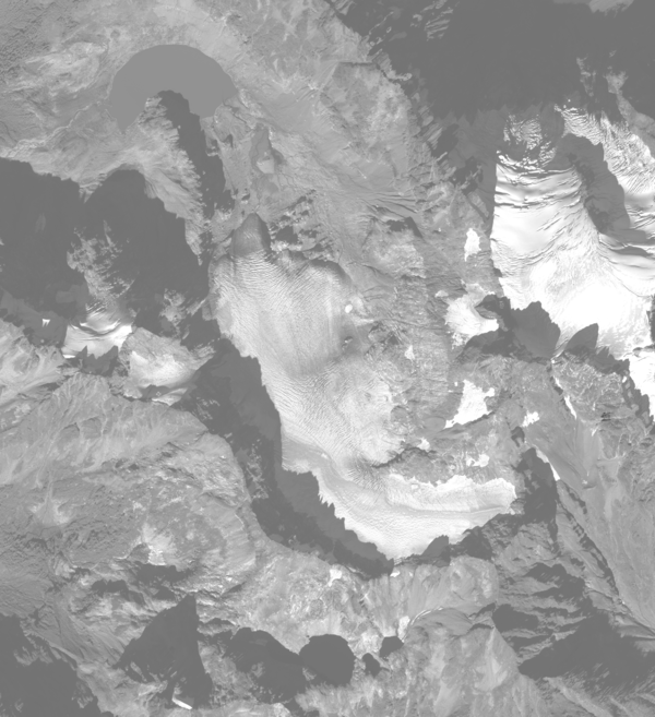
South Cascade Glacier October 14th, 2015
Aerial photograph of South Cascade Glacier, WA taken October 14th, 2015.
Aerial photograph of South Cascade Glacier, WA taken October 14th, 2015.

Great Salt Lake ADCP measurement at Bear River Bay causeway bridge
Great Salt Lake ADCP measurement at Bear River Bay causeway bridgeUSGS scientist makes ADCP measurement from canoe where the Bear River enters Great Salt Lake
Great Salt Lake ADCP measurement at Bear River Bay causeway bridge
Great Salt Lake ADCP measurement at Bear River Bay causeway bridgeUSGS scientist makes ADCP measurement from canoe where the Bear River enters Great Salt Lake

Bear River below Alexander Reservoir, Idaho
USGS hydrologic technician makes an ADCP measurement by walking across streambed on the Bear River below Alexander Reservoir, Idaho.
USGS hydrologic technician makes an ADCP measurement by walking across streambed on the Bear River below Alexander Reservoir, Idaho.

Great Salt Lake beach
USGS hydrologist walks across Great Salt Lake beach to reach receding shoreline.
USGS hydrologist walks across Great Salt Lake beach to reach receding shoreline.

Great Salt Lake, declining water level
Great Salt Lake, declining water level
Great Salt Lake, declining water level

Lake Fork above Moon Lake
Stilling well on Lake Fork above Moon Lake that is used to measure stream stage, and ultimately amount of water entering Moon Lake, on the south slope of the Uintas.
Stilling well on Lake Fork above Moon Lake that is used to measure stream stage, and ultimately amount of water entering Moon Lake, on the south slope of the Uintas.

Measuring discharge at 06324970
Measuring discharge at 06324970

Sediment Sampling at A72
Animas River downstream from Silverton, Colorado, showing right and left bank areas where streambed sediment sample was collected near USGS stream gage at site A72 (USGS site ID 09359020). Latitude 37.789964, Longitude -107.667394.
Animas River downstream from Silverton, Colorado, showing right and left bank areas where streambed sediment sample was collected near USGS stream gage at site A72 (USGS site ID 09359020). Latitude 37.789964, Longitude -107.667394.

Sagebrush, grasses, and forbs in a shrub-steppe ecosystem
Sagebrush, grasses, and forbs in a shrub-steppe ecosystemDetermining aboveground biomass of sagebrush, grasses, and forbs is important for estimating fuel loads, measuring carbon storage, and assessing habitat quality in shrublands. Remote sensing may offer a more efficient alternative to common, labor intensive methods of measuring aboveground biomass that are difficult to apply across large areas.
Sagebrush, grasses, and forbs in a shrub-steppe ecosystem
Sagebrush, grasses, and forbs in a shrub-steppe ecosystemDetermining aboveground biomass of sagebrush, grasses, and forbs is important for estimating fuel loads, measuring carbon storage, and assessing habitat quality in shrublands. Remote sensing may offer a more efficient alternative to common, labor intensive methods of measuring aboveground biomass that are difficult to apply across large areas.

Core from 2" well drilled into Wasatch Formation, Big Piney, WY
Core from 2" well drilled into Wasatch Formation, Big Piney, WYCore from 2" well drilled into Wasatch Formation, Big Piney, WY
Core from 2" well drilled into Wasatch Formation, Big Piney, WY
Core from 2" well drilled into Wasatch Formation, Big Piney, WYCore from 2" well drilled into Wasatch Formation, Big Piney, WY

Measuring pH
Measuring pH at the outlet of the fourth settling pond downstream from the North Fork Cement Creek. Latitude 37.894451, Longitude -107.64763.
Measuring pH at the outlet of the fourth settling pond downstream from the North Fork Cement Creek. Latitude 37.894451, Longitude -107.64763.