
Over 30 organizations and agencies are testing a USGS-developed oral sylvatic plague vaccine (SPV) at sites such as the Pitchfork Ranch in Wyoming, pictured here. If successful, the SPV could help protect endangered black-footed ferret populations in the western
Images
Images described and linked on this webpage come from a wide variety of USGS science activities and presentations performed by USGS Science Center staff members in the Region 7: Upper Colorado Basin. A search tool is provided to narrow the number of image files shown.
Filter Total Items: 551

Pitchfork Ranch, Wyoming
Over 30 organizations and agencies are testing a USGS-developed oral sylvatic plague vaccine (SPV) at sites such as the Pitchfork Ranch in Wyoming, pictured here. If successful, the SPV could help protect endangered black-footed ferret populations in the western

Stagecoach Lake, Steamboat, Colorado
Sunset at Stagecoach Lake, Steamboat, Colorado
Sunset at Stagecoach Lake, Steamboat, Colorado
Aerial photograph of the Truxton Basin, northwestern Arizona, showing boundaries and geologic features
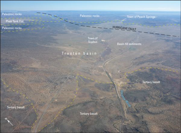
Aerial photograph of the Truxton Basin, northwestern Arizona, showing boundaries and geologic featuresAerial photograph of the Truxton basin, Arizona (view to northeast). Yellow dashed lines are approximate boundaries between labeled geologic features and units. From figure 2 in chapter B of Mason 2020
Aerial photograph of the Truxton Basin, northwestern Arizona, showing boundaries and geologic features
Aerial photograph of the Truxton Basin, northwestern Arizona, showing boundaries and geologic featuresAerial photograph of the Truxton basin, Arizona (view to northeast). Yellow dashed lines are approximate boundaries between labeled geologic features and units. From figure 2 in chapter B of Mason 2020

Using a bridge crane to measure streamflow, Powder River at Arvada
Using a bridge crane to measure streamflow, Powder River at ArvadaUsing a bridge crane to measure streamflow, Powder River at Arvada
Using a bridge crane to measure streamflow, Powder River at Arvada
Using a bridge crane to measure streamflow, Powder River at ArvadaUsing a bridge crane to measure streamflow, Powder River at Arvada

Lowering pump down monitoring well to sample for pesticides
Lowering pump down monitoring well to sample for pesticidesLowering pump down monitoring well to sample for pesticides
Lowering pump down monitoring well to sample for pesticides
Lowering pump down monitoring well to sample for pesticidesLowering pump down monitoring well to sample for pesticides

Sampling the Greybull River for pesticides
Sampling the Greybull River for pesticides

Water-quality sampling for pesticides, Shoshone River near Lovell
Water-quality sampling for pesticides, Shoshone River near LovellWater-quality sampling for pesticides, Shoshone River near Lovell
Water-quality sampling for pesticides, Shoshone River near Lovell
Water-quality sampling for pesticides, Shoshone River near LovellWater-quality sampling for pesticides, Shoshone River near Lovell

Water-quality sampling from Salt River cableway
Water-quality sampling from Salt River cableway

Digging trench to bury cable transmitting GW data to streamgage
Digging trench to bury cable transmitting GW data to streamgageDigging trench in which to bury cable transmitting groundwater data from well to streamgage
Digging trench to bury cable transmitting GW data to streamgage
Digging trench to bury cable transmitting GW data to streamgageDigging trench in which to bury cable transmitting groundwater data from well to streamgage

Setting up Groundwater Streamgage on Green River nr LaBarge
Setting up Groundwater Streamgage on Green River nr LaBargeSetting up Groundwater Streamgage on Green River nr LaBarge
Setting up Groundwater Streamgage on Green River nr LaBarge
Setting up Groundwater Streamgage on Green River nr LaBargeSetting up Groundwater Streamgage on Green River nr LaBarge

White River near Watson, Utah
Measuring discharge in White River near Watson, Utah using FlowTracker on sunny winter day.
Measuring discharge in White River near Watson, Utah using FlowTracker on sunny winter day.

An agricultural barn with farming equipment stored outside in Colorado
An agricultural barn with farming equipment stored outside in ColoradoAn agricultural barn with farming equipment stored outside in Colorado.
An agricultural barn with farming equipment stored outside in Colorado
An agricultural barn with farming equipment stored outside in ColoradoAn agricultural barn with farming equipment stored outside in Colorado.

A mangy wolf in Yellowstone National Park.

Sampling for aquatic invasive species in the Greater Yellowstone Area.
Sampling for aquatic invasive species in the Greater Yellowstone Area.Sampling for aquatic invasive species in the Greater Yellowstone Area.
Sampling for aquatic invasive species in the Greater Yellowstone Area.
Sampling for aquatic invasive species in the Greater Yellowstone Area.Sampling for aquatic invasive species in the Greater Yellowstone Area.

Wind Turbines During Approaching Storm
A field of wind turbines in Wyoming with a storm rolling in.
A field of wind turbines in Wyoming with a storm rolling in.

Red spotted toad.
Red spotted toad.

Sampling for aquatic invasive species in the Greater Yellowstone Area.
Sampling for aquatic invasive species in the Greater Yellowstone Area.Sampling for aquatic invasive species in the Greater Yellowstone Area.
Sampling for aquatic invasive species in the Greater Yellowstone Area.
Sampling for aquatic invasive species in the Greater Yellowstone Area.Sampling for aquatic invasive species in the Greater Yellowstone Area.

Wheat Field Wind Turbines in Wyoming
Wheat field wind turbines in Wyoming.
Wheat field wind turbines in Wyoming.

Colorado River near Moab
The Colorado River as it runs near Moab, UT, surrounded by sandstone cliffs.
The Colorado River as it runs near Moab, UT, surrounded by sandstone cliffs.

Colorado River near Moab
The Colorado River as it runs near Moab, UT, surrounded by sandstone cliffs.
The Colorado River as it runs near Moab, UT, surrounded by sandstone cliffs.

View into Green River Basin from Wyoming Range, Dry Piney Basin
View into Green River Basin from Wyoming Range, Dry Piney BasinView into Green River Basin from Wyoming Range, Dry Piney Basin
View into Green River Basin from Wyoming Range, Dry Piney Basin
View into Green River Basin from Wyoming Range, Dry Piney BasinView into Green River Basin from Wyoming Range, Dry Piney Basin