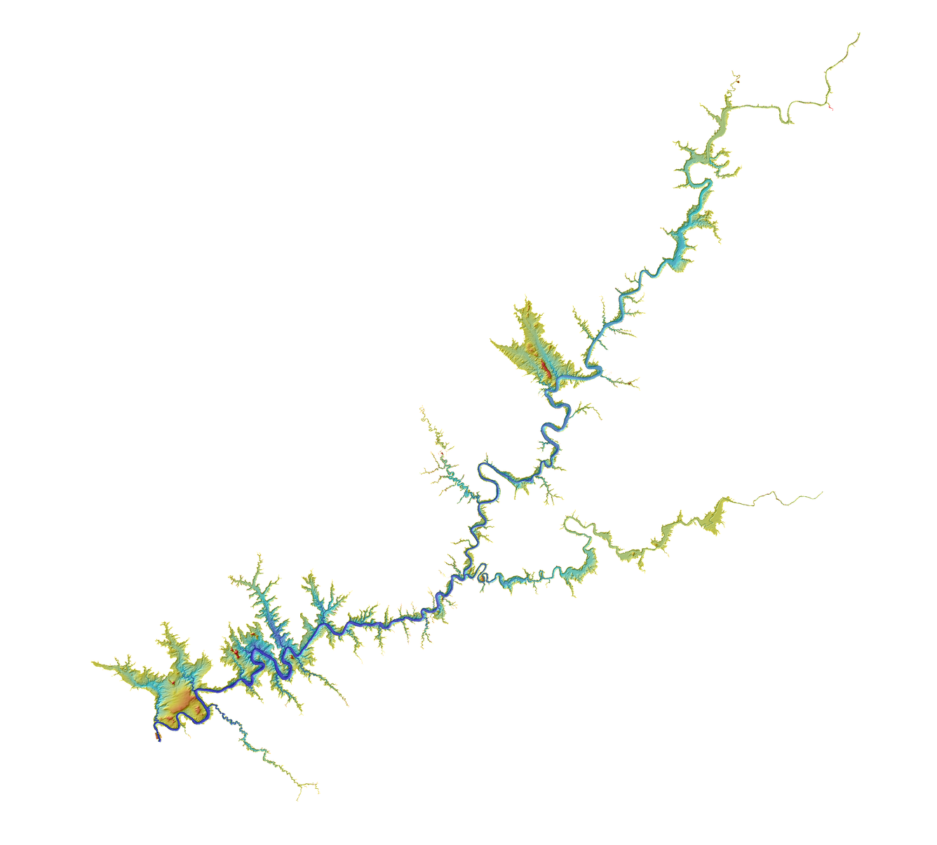
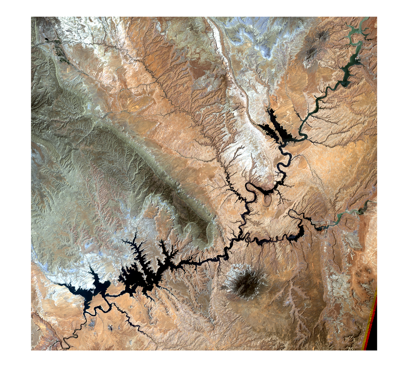
To support the modeling of the Colorado River water storage area capacity tables by the U.S. Geological Survey (USGS) Utah Water Science Center, the USGS Earth Resources Observation and Science (EROS) Center created a 3D high-resolution topobathymetric digital elevation model (TBDEM) for Lake Powell. Located in south-central Utah and north-central Arizona, the second largest man-made reservoir in the United States was created by the flooding of a natural canyon by the construction of Glen Canyon Dam.
Ranging from 1947-2018, land elevations derived from lidar and historic topographic surveys and bathymetric multibeam sonar were used to generate the seamless Lake Powell TBDEM. This best available multi-source 3D data product is valuable for assessing water storage capacity, sediment transport, time-series analysis of land and water change during times of drought or impacts from climate change.
This Department of the Interior (DOI) USGS EROS effort was in collaboration with the DOI Bureau of Reclamation, USGS Utah Water Science Center, and USGS Woods Hole Coastal and Marine Science Center.
Additional information and download capabilities regarding the Lake Powell TBDEM are located at https://doi.org/10.5066/P9XX0J1Y.
Below are other science projects associated with this project.
Coastal National Elevation Database (CoNED) Applications Project
USGS EROS Archive - Products Overview
Below are data or web applications associated with this project.
EarthExplorer
The EarthExplorer (EE) user interface is an online search, discovery, and ordering tool developed by the United States Geological Survey (USGS). EE supports the searching of satellite, aircraft, and other remote sensing inventories through interactive and textual-based query capabilities.
CoNED Project Viewer
The Coastal National Elevation Database (CoNED) Project Viewer is a portal to the topobathymetric models created with the expertise of the expertise of the U.S. Geological Survey Earth Resources Observation and Science (EROS) Center near Sioux Falls, SD.
- Overview
To support the modeling of the Colorado River water storage area capacity tables by the U.S. Geological Survey (USGS) Utah Water Science Center, the USGS Earth Resources Observation and Science (EROS) Center created a 3D high-resolution topobathymetric digital elevation model (TBDEM) for Lake Powell. Located in south-central Utah and north-central Arizona, the second largest man-made reservoir in the United States was created by the flooding of a natural canyon by the construction of Glen Canyon Dam.
Ranging from 1947-2018, land elevations derived from lidar and historic topographic surveys and bathymetric multibeam sonar were used to generate the seamless Lake Powell TBDEM. This best available multi-source 3D data product is valuable for assessing water storage capacity, sediment transport, time-series analysis of land and water change during times of drought or impacts from climate change.
This Department of the Interior (DOI) USGS EROS effort was in collaboration with the DOI Bureau of Reclamation, USGS Utah Water Science Center, and USGS Woods Hole Coastal and Marine Science Center.
Additional information and download capabilities regarding the Lake Powell TBDEM are located at https://doi.org/10.5066/P9XX0J1Y.
Topobathymetric elevation model of Lake Powell. USGS image created by Sandra Poppenga, Dean Tyler, and Jeff Danielson. Topobathymetric elevation model of Lake Powell. USGS image created by Sandra Poppenga, Dean Tyler, and Jeff Danielson. Sources/Usage: Public Domain.This video is a three-dimensional (3D) view of Lake Powell topobathymetric digital elevation model, which consists of topography (land elevation) and bathymetry (water depth). The 3D topobathymetric model was developed by the U.S. Geological Survey (USGS) Earth Resources Observation and Science (EROS) Center to support generation of the Colorado River water storage area capacity tables by the USGS Utah Water Science Center. This video shows the importance of high-resolution, detailed elevation information for the second largest man-made reservoir in the United States.
- Science
Below are other science projects associated with this project.
Coastal National Elevation Database (CoNED) Applications Project
High-resolution coastal elevation data is required to identify flood, hurricane, and sea-level rise inundation hazard zones and other earth science applications, such as the development of sediment transport and storm surge models. Light detection and ranging (lidar) enables the rapid collection of very accurate elevation data over large areas, and during the last decade, airborne laser altimetry...Coastal National Elevation Database (CoNED) Applications Project
High-resolution coastal elevation data is required to identify flood, hurricane, and sea-level rise inundation hazard zones and other earth science applications, such as the development of sediment transport and storm surge models. Light detection and ranging (lidar) enables the rapid collection of very accurate elevation data over large areas, and during the last decade, airborne laser altimetry...USGS EROS Archive - Products Overview
Explore the world’s largest civilian collection of images of the Earth’s surface. Find satellite images and data, aerial photography, elevation and land cover datasets, digitized maps, and our Image Gallery collections. - Web Tools
Below are data or web applications associated with this project.
EarthExplorer
The EarthExplorer (EE) user interface is an online search, discovery, and ordering tool developed by the United States Geological Survey (USGS). EE supports the searching of satellite, aircraft, and other remote sensing inventories through interactive and textual-based query capabilities.
ByEarth Resources Observation and Science (EROS) Center , Commercial Remote Sensing Space Policy, Landsat Missions, Coastal National Elevation Database (CoNED) Applications Project, Elevation Derivatives for National Applications (EDNA), Land Change Monitoring, Assessment, and Projection, Significant Topographic Changes in the United StatesCoNED Project Viewer
The Coastal National Elevation Database (CoNED) Project Viewer is a portal to the topobathymetric models created with the expertise of the expertise of the U.S. Geological Survey Earth Resources Observation and Science (EROS) Center near Sioux Falls, SD.