
Copper mining, critical minerals, and long-term drought in the Southwest United States
Copper Mine near Safford, Arizona
Long-term drought in the Southwest U.S. affects water use across many sectors as well as the natural environment. The Southwest U.S. is an important area for mining porphyry copper deposits, which consist of copper minerals disseminated in breccia, a type of rock composed of coarse rock fragments held together by cement or a fine-grained matrix, that are the World's largest source of copper (Jackson, 1997; and John and others, 2010). These deposits also contain secondary critical minerals vital for development of energy and technological infrastructure. Mining and processing of ores require large quantities of water. This webpage presents an overview of the complex relations between water availability for porphyry copper mining and long-term drought in the Southwest U.S., prepared as part of the USGS Colorado River Basin Actionable and Strategic Integrated Science and Technology (ASIST) initiative.
Part 1. Drought
Drought typically is a prolonged and widespread deficit in water supplies available for communities and ecosystems. Water demands for human consumption, agricultural production, and industrial activity, including mining, can exacerbate the effects of drought in a region.
Additional USGS Drought Science
USGS Drought Website
USGS Drought and Climate Website
Historic Drought in the Colorado River Basin
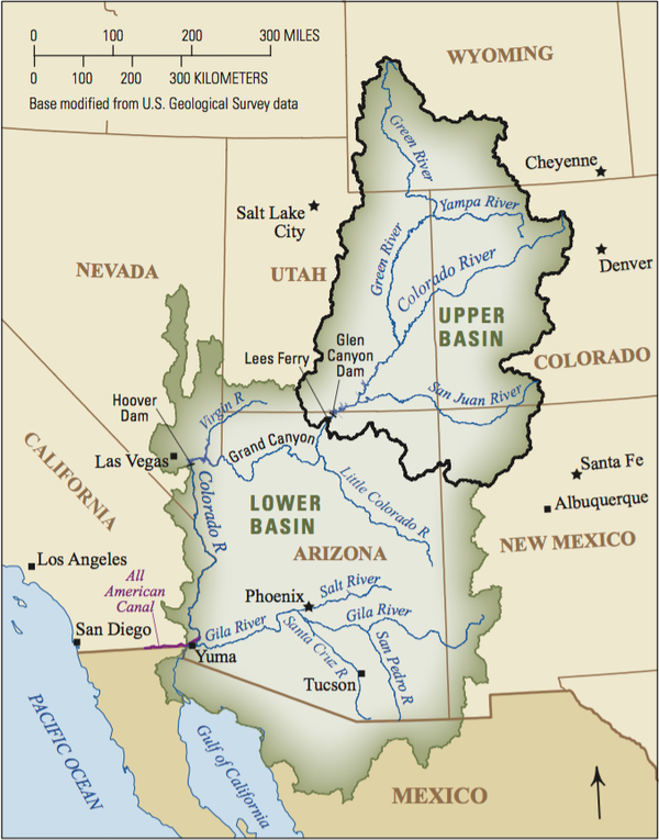
In the Colorado River Basin (map shown below), the years from 2000 through 2020 were the driest 21-year period in more than 100 years and one of the driest periods in the last 1,200 years (Open Water Data Initiative, 2020; Williams and others, 2020). Since 2000 there has been a decrease in precipitation and an increase in temperatures in the Lower Colorado River Basin. Increasing temperatures increase evaporation of water, worsening the severity of drought conditions (Tillman and others, 2020).
Drought effects in the basin and adjoining areas may include:
- Enhanced risk of severe wildfires,
- Reduced snowpack, streamflow, and groundwater recharge,
- Reduced water availability for agricultural production,
- Reduced recreational opportunities on public lands, and
- Degraded habitat for more than 60 threatened and endangered species;
Map of the Colorado River Basin
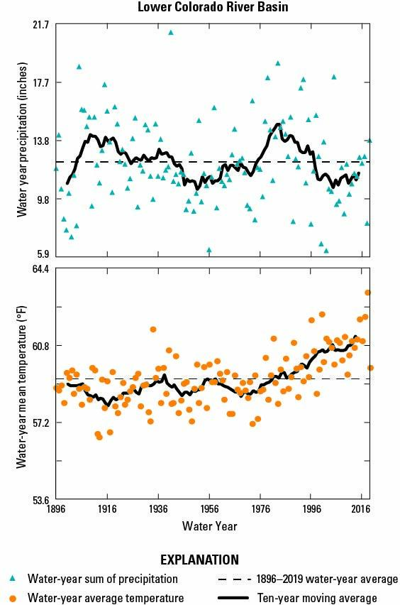
Graphs showing water-year precipitation and air temperatures in the Lower Colorado River Basin from 1896-2019 (Tillman and others, 2020). Note periods of relatively small amounts of precipitation in the early 1900s, 1940-70, and 1996-2019.
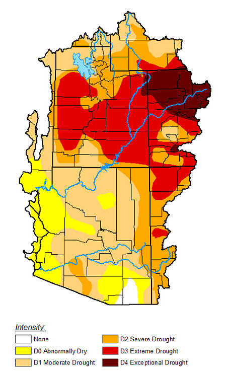
Map showing drought intensity in the National Oceanic and Atmospheric Administration (NOAA) River Forecast Center Area for the week of April 7, 2026 (U.S. Drought Monitor, 2026). This area includes part of the Great Basin watershed in western Utah.
Part 2. Copper Sources
Increasing amounts of copper are needed to supply increasing demand for infrastructure to generate and transmit electrical power and for other uses. The Lower Colorado River Basin contains substantial unmined copper reserves. Arizona is the leading copper-producing state, accounting for more than 70% of domestic output in 2024 (U.S. Geological Survey, 2025a).
Where are Copper Deposits Located?
Most of the copper production in the Colorado River Basin is from low-grade, disseminated copper ores known as porphyry deposits. Porphyry deposits form in magmatic arcs overlying subduction zones. Porphyry deposits are the world’s largest source of copper and the only source of the critical mineral tellurium.
Arizona, which composes most of the Lower Colorado River Basin, is the leading copper producing state in the U.S. Total U.S. copper production in 2019 was 1.87 million metric tons, with Arizona accounting for 73 percent of that amount, followed by Utah (12 percent), New Mexico (10 percent), Nevada (4 percent), and Michigan (1 percent) (Flanagan, 2019). Four of those five states are in the semi-arid to arid southwest U.S.
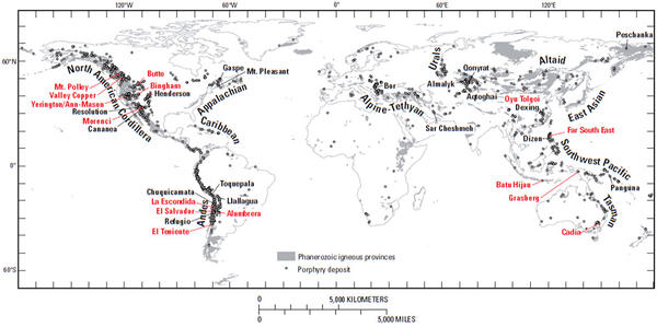
Global Map Showing Locations of Porphyry Copper Deposits (John and others, 2010). Click on map image to see full-size image.
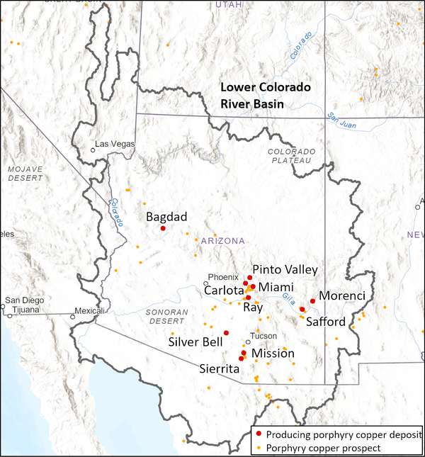
Map Showing Leading Copper-Producing Mines in the Lower Colorado River Basin 2024 (data from Flanagan, 2019) and porphyry copper prospects (data from Magnin and others, 2025). The Lower Colorado River Basin has considerable potential for future mining operations.
Part 3. Water Use, Mining, and Drought
Mining, which accounted for about 1 percent of total water use in Arizona in 2015, draws water for processing ores, dust control, and other purposes. In 2015, groundwater withdrawals comprised 72% of the total withdrawals used for mining (Dieter and others, 2018). Water sources of mines typically are different than those used by municipalities and surface ecosystems. Mines typically withdraw water from deep bedrock aquifers hundreds of feet below basin-fill sedimentary and fractured rock stratigraphic units that are more typical sources of water for humans and ecosystems. However, in some cases, pumping of groundwater to dewater mineral-bearing deposits can lower groundwater-table elevations by tens of feet for several miles away from mine sites (U.S. Geological Survey, 2025b).
Modern mining practices conserve water through minimizing water use and retaining and recycling practices. Several large mines discharge treated water to active management areas. To the extent that mines discharge treated water pumped from deep bedrock units to surface drainages, they can increase streamflows and water levels in adjoining shallower aquifers. Mining companies are aware that pumping, treating, and disposing of water pose substantial costs to mining operations, so there are economic, as well as environmental and regulatory permitting incentives, to minimize use of water at mines.
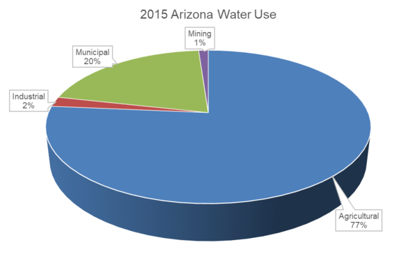
Water withdrawals for purposes other than mining are much greater than withdrawals for mining. Agriculture was the largest user of water in Arizona in 2015, (77 percent) with municipal water withdrawals composing 20 percent of total water use in the State (see pie chart below, Deiter and others, 2018).
Schematic Diagram of Water Flow for Conventional Flotation Processing of Copper Ores (Bleiwas, 2012). Click on image to see full-size image.
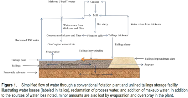
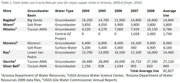
Table Showing Total Water Use by Major Copper Mines in Arizona (2004-8; Singh, 2010). Click on the image to see a larger image.
Pie Chart Showing Water Use in Arizona by Category in 2015 (Data from Deiter and others, 2018). Click on the image to see a larger image.
Part 4. Uses of Copper and Other Critical Minerals for Vital Infrastructure
In addition to copper, porphyry deposits and mine tailings from such deposits may contain notable quantities of other minerals deemed to be critical for uses in infrastructure and advanced technology, including antimony, arsenic, bismuth, rhenium, and tellurium and possibly gallium, germanium, indium, tin, and tungsten (Vikre and others, 2023).
Copper is a vital component for a wide range of technology used to generate, store, and transmit electricity, including wind turbines, hydroelectric turbines, transformers, transmission lines, building wiring systems, solar panels, electric vehicles, and batteries; and many other purposes such as transportation, water service lines, computers, and appliances (Kotrba, 2025, Copper Development Association Incorporated, 2025). Copper and critical minerals also are important components of medical implants, semiconductors and other components in computers, cell phones, satellites, fiber optics, metal alloys, and infrared detectors (U.S. Geological Survey, 2025c; and Geoscience Australia, 2024).
Part 5. Summary
- Water in the Colorado River Basin is vital for human populations, natural ecosystems, agriculture, and industrial activities, including mining. Drought can exacerbate competition and conflicts among these water users.
- Mining is a relatively small user of water that can locally increase or decrease water availability at and near the land surface.
- Porphyry deposits can contain large amounts of copper and other critical minerals needed to develop energy sources and for many other vital purposes.
References
- Bleiwas, D.I., 2012, Estimated water requirements for the conventional flotation of copper ores: U.S. Geological Survey Open-File Report 2012–1089, 13 p., available at https://pubs.usgs.gov/publication/ofr20121089
- Copper Development Association Incorporated, 2025, Building wire, available at: https://copper.org/applications/electrical/building/
- Dieter, C.A., Linsey, K.S., Caldwell, R.R., Harris, M.A., Ivahnenko, T.I., Lovelace, J.K., Maupin, M.A., and Barber, N.L., 2018, Estimated Use of Water in the United States County-Level Data for 2015 (ver. 2.0, June 2018): U.S. Geological Survey data release, https://doi.org/10.5066/F7TB15V5.
- Doebrich, Jeff, 2009, Copper–A Metal for the Ages: U.S. Geological Survey Fact Sheet 2009-3031, 4 p., available at https://pubs.usgs.gov/fs/2009/3031/
- Flanagan, D.M., 2019, Copper, in Metals and minerals: U.S. Geological Survey Minerals Yearbook 2019, v. 1, pp. 52-53, available at https://d9-wret.s3-us-west-2.amazonaws.com/assets/palladium/production/s3fs-public/atoms/files/mcs-2019-coppe.pdf
- Geosciences Australia, 2024, Critical minerals and their uses, available at https://www.ga.gov.au/scientific-topics/minerals/critical-minerals/critical-minerals-and-their-uses
- Jackson, Julia A., ed. (1997). "breccia". Glossary of geology (Fourth ed.). Alexandria, Virginia: American Geological Institute. ISBN 0922152349.
- John, D.A., Ayuso, R.A., Barton, M.D., Blakely, R.J., Bodnar, R.J., Dilles, J.H., Gray, Floyd, Graybeal, F.T., Mars, J.C., McPhee, D.K., Seal, R.R., Taylor, R.D., and Vikre, P.G., 2010, Porphyry copper deposit model, chap. B of Mineral deposit models for resource assessment: U.S. Geological Survey Scientific Investigations Report 2010–5070–B, 169 p., available at https://pubs.usgs.gov/sir/2010/5070/b/
- Johnson, K.M., Hammarstrom, J.M., Zientek, M.L., and Dicken, C.L., 2014, Estimate of undiscovered copper resources of the world, 2013: U.S. Geological Survey Fact Sheet 2014–3004, 3 p., available at https://dx.doi.org/10.3133/fs20143004
- Kotrba, Adam, 2025, Transforming energy systems with the power of copper: Copper Development Association Incorporated, available at: https://blog.copper.org/electrical-oem/transforming-energy-systems
- Magnin, B.P., Graham, G.E., Huston, D.L., and Eglington, B.M., 2025, A global database of porphyry copper deposits and prospects: U.S. Geological Survey data release, available at https://doi.org/10.5066/P14CCESQ
- Open Water Data Initiative, 2020, Drought in the Colorado River Basin, Insights using open data, available at https://labs.waterdata.usgs.gov/visualizations/ODWI-drought/en/index.html
- Singh, M.M., 2010, Water consumption at copper mines in Arizona: State of Arizona, Department of Mines and Mineral Resources, Special Report 29, 16 p., available at https://repository.arizona.edu/bitstream/handle/10150/63044/sr29waterconsumptioncoppermines.pdf
- Tillman, F.D., Gangopadhyay, S., and Pruitt, T., 2020, Trends in recent historical and projected climate data for the Colorado River Basin and potential effects on groundwater availability: U.S. Geological Survey Scientific Investigations Report 2020–5107, 24 p., available at https://doi.org/10.3133/sir20205107
- U.S. Drought Monitor, 2026, Map Archive, April 7, 2026, Colorado River Basin River Forecast Center, Cumulative Statistics: U.S. Drought Monitor, available at https://droughtmonitor.unl.edu/Maps/MapArchive.aspx
- U.S. Geological Survey, 2025a, Mineral commodity summaries 2025: available at https://pubs.usgs.gov/periodicals/mcs2025/mcs2025-copper.pdf
- U.S. Geological Survey, 2025b, Freeport McMoRan-Safford Mine Groundwater Monitoring, available at https://geonarrative.usgs.gov/freeportmcmorangwmonitor/
- U.S. Geological Survey, 2025c, What are critical minerals?, available at https://www.usgs.gov/programs/mineral-resources-program/science/what-are-critical-minerals-0#Everyday
- Vikre, P., John, D., Wintzer, N.E., Koutz, F., Graybeal, C.C., and Annis, D.C., 2023, Critical minerals in subduction-related magmatic-hydrothermal systems of the United States: U.S. Geological Survey, Scientific Investigations Report 2023-5082, 110 p., available at https://dx.doi.org/10.3133/sir20235082
- Williams, A.P.; Cook, E.R.; Smerdon, J.E.; Cook, B.I.; Abatzoglou, J.T.; Bolles, K.; Baek, S.H.; Badger, A.M.; Livneh, B., 2020, Large contribution from anthropogenic warming to an emerging North American megadrought: Science, vol. 368, pp. 314–318, available at https://www.science.org/doi/10.1126/science.aaz9600
Long-term drought in the Southwest U.S. affects water use across many sectors as well as the natural environment. The Southwest U.S. is an important area for mining porphyry copper deposits, which consist of copper minerals disseminated in breccia, a type of rock composed of coarse rock fragments held together by cement or a fine-grained matrix, that are the World's largest source of copper (Jackson, 1997; and John and others, 2010). These deposits also contain secondary critical minerals vital for development of energy and technological infrastructure. Mining and processing of ores require large quantities of water. This webpage presents an overview of the complex relations between water availability for porphyry copper mining and long-term drought in the Southwest U.S., prepared as part of the USGS Colorado River Basin Actionable and Strategic Integrated Science and Technology (ASIST) initiative.
Part 1. Drought
Drought typically is a prolonged and widespread deficit in water supplies available for communities and ecosystems. Water demands for human consumption, agricultural production, and industrial activity, including mining, can exacerbate the effects of drought in a region.
Additional USGS Drought Science
USGS Drought Website
USGS Drought and Climate Website
Historic Drought in the Colorado River Basin
In the Colorado River Basin (map shown below), the years from 2000 through 2020 were the driest 21-year period in more than 100 years and one of the driest periods in the last 1,200 years (Open Water Data Initiative, 2020; Williams and others, 2020). Since 2000 there has been a decrease in precipitation and an increase in temperatures in the Lower Colorado River Basin. Increasing temperatures increase evaporation of water, worsening the severity of drought conditions (Tillman and others, 2020).
Drought effects in the basin and adjoining areas may include:
- Enhanced risk of severe wildfires,
- Reduced snowpack, streamflow, and groundwater recharge,
- Reduced water availability for agricultural production,
- Reduced recreational opportunities on public lands, and
- Degraded habitat for more than 60 threatened and endangered species;
Map of the Colorado River Basin
Graphs showing water-year precipitation and air temperatures in the Lower Colorado River Basin from 1896-2019 (Tillman and others, 2020). Note periods of relatively small amounts of precipitation in the early 1900s, 1940-70, and 1996-2019.
Map showing drought intensity in the National Oceanic and Atmospheric Administration (NOAA) River Forecast Center Area for the week of April 7, 2026 (U.S. Drought Monitor, 2026). This area includes part of the Great Basin watershed in western Utah.
Part 2. Copper Sources
Increasing amounts of copper are needed to supply increasing demand for infrastructure to generate and transmit electrical power and for other uses. The Lower Colorado River Basin contains substantial unmined copper reserves. Arizona is the leading copper-producing state, accounting for more than 70% of domestic output in 2024 (U.S. Geological Survey, 2025a).
Where are Copper Deposits Located?
Most of the copper production in the Colorado River Basin is from low-grade, disseminated copper ores known as porphyry deposits. Porphyry deposits form in magmatic arcs overlying subduction zones. Porphyry deposits are the world’s largest source of copper and the only source of the critical mineral tellurium.
Arizona, which composes most of the Lower Colorado River Basin, is the leading copper producing state in the U.S. Total U.S. copper production in 2019 was 1.87 million metric tons, with Arizona accounting for 73 percent of that amount, followed by Utah (12 percent), New Mexico (10 percent), Nevada (4 percent), and Michigan (1 percent) (Flanagan, 2019). Four of those five states are in the semi-arid to arid southwest U.S.
Global Map Showing Locations of Porphyry Copper Deposits (John and others, 2010). Click on map image to see full-size image.
Map Showing Leading Copper-Producing Mines in the Lower Colorado River Basin 2024 (data from Flanagan, 2019) and porphyry copper prospects (data from Magnin and others, 2025). The Lower Colorado River Basin has considerable potential for future mining operations.
Part 3. Water Use, Mining, and Drought
Mining, which accounted for about 1 percent of total water use in Arizona in 2015, draws water for processing ores, dust control, and other purposes. In 2015, groundwater withdrawals comprised 72% of the total withdrawals used for mining (Dieter and others, 2018). Water sources of mines typically are different than those used by municipalities and surface ecosystems. Mines typically withdraw water from deep bedrock aquifers hundreds of feet below basin-fill sedimentary and fractured rock stratigraphic units that are more typical sources of water for humans and ecosystems. However, in some cases, pumping of groundwater to dewater mineral-bearing deposits can lower groundwater-table elevations by tens of feet for several miles away from mine sites (U.S. Geological Survey, 2025b).
Modern mining practices conserve water through minimizing water use and retaining and recycling practices. Several large mines discharge treated water to active management areas. To the extent that mines discharge treated water pumped from deep bedrock units to surface drainages, they can increase streamflows and water levels in adjoining shallower aquifers. Mining companies are aware that pumping, treating, and disposing of water pose substantial costs to mining operations, so there are economic, as well as environmental and regulatory permitting incentives, to minimize use of water at mines.
Water withdrawals for purposes other than mining are much greater than withdrawals for mining. Agriculture was the largest user of water in Arizona in 2015, (77 percent) with municipal water withdrawals composing 20 percent of total water use in the State (see pie chart below, Deiter and others, 2018).
Schematic Diagram of Water Flow for Conventional Flotation Processing of Copper Ores (Bleiwas, 2012). Click on image to see full-size image.
Table Showing Total Water Use by Major Copper Mines in Arizona (2004-8; Singh, 2010). Click on the image to see a larger image.
Pie Chart Showing Water Use in Arizona by Category in 2015 (Data from Deiter and others, 2018). Click on the image to see a larger image.
Part 4. Uses of Copper and Other Critical Minerals for Vital Infrastructure
In addition to copper, porphyry deposits and mine tailings from such deposits may contain notable quantities of other minerals deemed to be critical for uses in infrastructure and advanced technology, including antimony, arsenic, bismuth, rhenium, and tellurium and possibly gallium, germanium, indium, tin, and tungsten (Vikre and others, 2023).
Copper is a vital component for a wide range of technology used to generate, store, and transmit electricity, including wind turbines, hydroelectric turbines, transformers, transmission lines, building wiring systems, solar panels, electric vehicles, and batteries; and many other purposes such as transportation, water service lines, computers, and appliances (Kotrba, 2025, Copper Development Association Incorporated, 2025). Copper and critical minerals also are important components of medical implants, semiconductors and other components in computers, cell phones, satellites, fiber optics, metal alloys, and infrared detectors (U.S. Geological Survey, 2025c; and Geoscience Australia, 2024).
Part 5. Summary
- Water in the Colorado River Basin is vital for human populations, natural ecosystems, agriculture, and industrial activities, including mining. Drought can exacerbate competition and conflicts among these water users.
- Mining is a relatively small user of water that can locally increase or decrease water availability at and near the land surface.
- Porphyry deposits can contain large amounts of copper and other critical minerals needed to develop energy sources and for many other vital purposes.
References
- Bleiwas, D.I., 2012, Estimated water requirements for the conventional flotation of copper ores: U.S. Geological Survey Open-File Report 2012–1089, 13 p., available at https://pubs.usgs.gov/publication/ofr20121089
- Copper Development Association Incorporated, 2025, Building wire, available at: https://copper.org/applications/electrical/building/
- Dieter, C.A., Linsey, K.S., Caldwell, R.R., Harris, M.A., Ivahnenko, T.I., Lovelace, J.K., Maupin, M.A., and Barber, N.L., 2018, Estimated Use of Water in the United States County-Level Data for 2015 (ver. 2.0, June 2018): U.S. Geological Survey data release, https://doi.org/10.5066/F7TB15V5.
- Doebrich, Jeff, 2009, Copper–A Metal for the Ages: U.S. Geological Survey Fact Sheet 2009-3031, 4 p., available at https://pubs.usgs.gov/fs/2009/3031/
- Flanagan, D.M., 2019, Copper, in Metals and minerals: U.S. Geological Survey Minerals Yearbook 2019, v. 1, pp. 52-53, available at https://d9-wret.s3-us-west-2.amazonaws.com/assets/palladium/production/s3fs-public/atoms/files/mcs-2019-coppe.pdf
- Geosciences Australia, 2024, Critical minerals and their uses, available at https://www.ga.gov.au/scientific-topics/minerals/critical-minerals/critical-minerals-and-their-uses
- Jackson, Julia A., ed. (1997). "breccia". Glossary of geology (Fourth ed.). Alexandria, Virginia: American Geological Institute. ISBN 0922152349.
- John, D.A., Ayuso, R.A., Barton, M.D., Blakely, R.J., Bodnar, R.J., Dilles, J.H., Gray, Floyd, Graybeal, F.T., Mars, J.C., McPhee, D.K., Seal, R.R., Taylor, R.D., and Vikre, P.G., 2010, Porphyry copper deposit model, chap. B of Mineral deposit models for resource assessment: U.S. Geological Survey Scientific Investigations Report 2010–5070–B, 169 p., available at https://pubs.usgs.gov/sir/2010/5070/b/
- Johnson, K.M., Hammarstrom, J.M., Zientek, M.L., and Dicken, C.L., 2014, Estimate of undiscovered copper resources of the world, 2013: U.S. Geological Survey Fact Sheet 2014–3004, 3 p., available at https://dx.doi.org/10.3133/fs20143004
- Kotrba, Adam, 2025, Transforming energy systems with the power of copper: Copper Development Association Incorporated, available at: https://blog.copper.org/electrical-oem/transforming-energy-systems
- Magnin, B.P., Graham, G.E., Huston, D.L., and Eglington, B.M., 2025, A global database of porphyry copper deposits and prospects: U.S. Geological Survey data release, available at https://doi.org/10.5066/P14CCESQ
- Open Water Data Initiative, 2020, Drought in the Colorado River Basin, Insights using open data, available at https://labs.waterdata.usgs.gov/visualizations/ODWI-drought/en/index.html
- Singh, M.M., 2010, Water consumption at copper mines in Arizona: State of Arizona, Department of Mines and Mineral Resources, Special Report 29, 16 p., available at https://repository.arizona.edu/bitstream/handle/10150/63044/sr29waterconsumptioncoppermines.pdf
- Tillman, F.D., Gangopadhyay, S., and Pruitt, T., 2020, Trends in recent historical and projected climate data for the Colorado River Basin and potential effects on groundwater availability: U.S. Geological Survey Scientific Investigations Report 2020–5107, 24 p., available at https://doi.org/10.3133/sir20205107
- U.S. Drought Monitor, 2026, Map Archive, April 7, 2026, Colorado River Basin River Forecast Center, Cumulative Statistics: U.S. Drought Monitor, available at https://droughtmonitor.unl.edu/Maps/MapArchive.aspx
- U.S. Geological Survey, 2025a, Mineral commodity summaries 2025: available at https://pubs.usgs.gov/periodicals/mcs2025/mcs2025-copper.pdf
- U.S. Geological Survey, 2025b, Freeport McMoRan-Safford Mine Groundwater Monitoring, available at https://geonarrative.usgs.gov/freeportmcmorangwmonitor/
- U.S. Geological Survey, 2025c, What are critical minerals?, available at https://www.usgs.gov/programs/mineral-resources-program/science/what-are-critical-minerals-0#Everyday
- Vikre, P., John, D., Wintzer, N.E., Koutz, F., Graybeal, C.C., and Annis, D.C., 2023, Critical minerals in subduction-related magmatic-hydrothermal systems of the United States: U.S. Geological Survey, Scientific Investigations Report 2023-5082, 110 p., available at https://dx.doi.org/10.3133/sir20235082
- Williams, A.P.; Cook, E.R.; Smerdon, J.E.; Cook, B.I.; Abatzoglou, J.T.; Bolles, K.; Baek, S.H.; Badger, A.M.; Livneh, B., 2020, Large contribution from anthropogenic warming to an emerging North American megadrought: Science, vol. 368, pp. 314–318, available at https://www.science.org/doi/10.1126/science.aaz9600