
The historical Berkeley Pit in Butte, Montana was developed during open-pit mining of polymetallic veins that overlie a porphyry stockwork vein deposit at depth. The veins are hosted in the Butte granite, one of many granitic phases of the Boulder batholith. View is to the north-northeast.
Eric D. Anderson, Ph.D.
Eric Anderson is a Research Geophysicist with the Geology, Geophysics, and Geochemistry Science Center.
Eric's research is focused on solving mineral resource problems through the theory and application of geophysical methods. He integrates geophysical data with geology and mineral deposit models to understand the three-dimensional geologic framework within which ore deposits occur. He works mostly in the western US on mineral deposits that form in convergent margin settings.
Science and Products

Copper mining, critical minerals, and long-term drought in the Southwest United States
Long-term drought in the Southwest U.S. affects water use across many sectors as well as the natural environment. The Southwest U.S. is an important area for mining porphyry copper deposits, which consist of copper minerals disseminated in breccia, a type of rock composed of coarse rock fragments held together by cement or a fine-grained matrix, that are the World's largest source of copper...

Porphyry Copper Systems of the Boulder batholith, Montana
The project seeks to better understand the mineral systems of the Boulder batholith and surrounding region in Montana using new airborne geophysical data in conjunction with geologic mapping.

A Shallow to Deep View Inside the Hydrothermally Altered and Mineralized Silverton Caldera Complex: New Geologic Insights Gained From Modern Geophysical Interpretations
The Silverton caldera complex in southwest Colorado hosts base and precious metals that have been mined since the late 1800s. Extensive mine workings, excellent bedrock exposures, and deeply incised drainages make this area a natural laboratory ideally suited for furthering our understanding of the mineral systems in a volcanic environment. In addition, state-of-the-art geophysical data processing...

National Geophysical Data Retrieval and Integration Project
This project helped to streamline the workflow from geophysical data acquisition to data distribution, and additionally provided user support for integration and interpretation of these complex data sets. There were four main objectives: 1) contracting geophysical surveys, 2) converting data from analog to digital format, 3) archiving, retrieving, and integrating geophysical data, and 4) outreach.

Berkeley Pit, Butte, Montana
The historical Berkeley Pit in Butte, Montana was developed during open-pit mining of polymetallic veins that overlie a porphyry stockwork vein deposit at depth. The veins are hosted in the Butte granite, one of many granitic phases of the Boulder batholith. View is to the north-northeast.
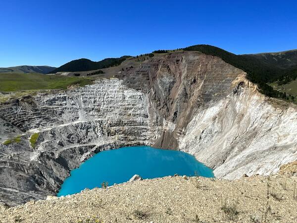
Montana Tunnels open pit
Montana Tunnels mine open pit with vibrant blue pit lake at the bottom located near Wickes, Montana.
Montana Tunnels mine open pit with vibrant blue pit lake at the bottom located near Wickes, Montana.
Science and Products
Copper mining, critical minerals, and long-term drought in the Southwest United States
Long-term drought in the Southwest U.S. affects water use across many sectors as well as the natural environment. The Southwest U.S. is an important area for mining porphyry copper deposits, which consist of copper minerals disseminated in breccia, a type of rock composed of coarse rock fragments held together by cement or a fine-grained matrix, that are the World's largest source of copper...
Porphyry Copper Systems of the Boulder batholith, Montana
The project seeks to better understand the mineral systems of the Boulder batholith and surrounding region in Montana using new airborne geophysical data in conjunction with geologic mapping.
A Shallow to Deep View Inside the Hydrothermally Altered and Mineralized Silverton Caldera Complex: New Geologic Insights Gained From Modern Geophysical Interpretations
The Silverton caldera complex in southwest Colorado hosts base and precious metals that have been mined since the late 1800s. Extensive mine workings, excellent bedrock exposures, and deeply incised drainages make this area a natural laboratory ideally suited for furthering our understanding of the mineral systems in a volcanic environment. In addition, state-of-the-art geophysical data processing...
National Geophysical Data Retrieval and Integration Project
This project helped to streamline the workflow from geophysical data acquisition to data distribution, and additionally provided user support for integration and interpretation of these complex data sets. There were four main objectives: 1) contracting geophysical surveys, 2) converting data from analog to digital format, 3) archiving, retrieving, and integrating geophysical data, and 4) outreach.
Berkeley Pit, Butte, Montana
The historical Berkeley Pit in Butte, Montana was developed during open-pit mining of polymetallic veins that overlie a porphyry stockwork vein deposit at depth. The veins are hosted in the Butte granite, one of many granitic phases of the Boulder batholith. View is to the north-northeast.
The historical Berkeley Pit in Butte, Montana was developed during open-pit mining of polymetallic veins that overlie a porphyry stockwork vein deposit at depth. The veins are hosted in the Butte granite, one of many granitic phases of the Boulder batholith. View is to the north-northeast.
Montana Tunnels open pit
Montana Tunnels mine open pit with vibrant blue pit lake at the bottom located near Wickes, Montana.
Montana Tunnels mine open pit with vibrant blue pit lake at the bottom located near Wickes, Montana.
*Disclaimer: Listing outside positions with professional scientific organizations on this Staff Profile are for informational purposes only and do not constitute an endorsement of those professional scientific organizations or their activities by the USGS, Department of the Interior, or U.S. Government