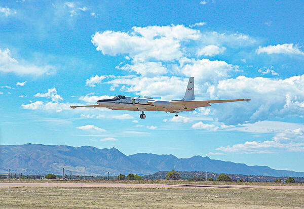
U.S. flag

An official website of the United States government

Images

Images intro.
Filter Total Items: 26
Image shows a map of south-central Wyoming with the survey area marked in a blue polygon
Medicine Bow LLFA Survey Map
Image shows a map of the United States, including Alaska, Puerto Rico and Hawaii, with locations of mineral systems marked
Mineral Systems Map of the United States

Maps showing parts of 23 mineral systems that could host critical mineral resources in the United States.  These areas are used to prioritize data collection and analysis by Earth MRI.

Maps showing parts of 23 mineral systems that could host critical mineral resources in the United States.  These areas are used to prioritize data collection and analysis by Earth MRI.

Image shows a mountain landscape with trees and snow-covered peaks
Montana
Montana
Montana

A view of the Boulder Mountains from US-12 west of Helena. These mountains lie at the north end of the Boulder Batholith.

A view of the Boulder Mountains from US-12 west of Helena. These mountains lie at the north end of the Boulder Batholith.

Image shows a small aircraft at an airport with a stinger tail on it for the airborne geophysical data collection
Aircraft with Geophysical Survey Equipment

A typical survey airplane. The magnetic sensor is placed in an extension on the back of the airplane to reduce the impact of the airplane’s own magnetic field. 

A typical survey airplane. The magnetic sensor is placed in an extension on the back of the airplane to reduce the impact of the airplane’s own magnetic field. 

Image shows a scan of airborne geophysical data with an anomaly shown in detail
Pennington Mountain Critical Minerals Earth MRI Geophysical Scan

The anomaly at Pennington Mountain is visible in the geophysical data collected in aerial surveys conducted in 2021.

Image shows a detailed view of a rock with the tip of a pencil for scale
Pennington Mountain Rock with Critical Minerals

A fine-grained volcanic rock (trachyte) that hosts rare earth elements, niobium, and zirconium, all which are considered critical mineral resources. This rock was found on Pennington Mountain in Maine. Image courtesy of Chunzeng Wang, University of Maine-Presque Isle.

A fine-grained volcanic rock (trachyte) that hosts rare earth elements, niobium, and zirconium, all which are considered critical mineral resources. This rock was found on Pennington Mountain in Maine. Image courtesy of Chunzeng Wang, University of Maine-Presque Isle.

Piper Navajo fixed-wing aircraft with rear facing stinger magnetometer

A Piper Navajo fixed-wing aircraft with rear facing stinger magnetometer. Credit: New-Sense Geophysics Limited 

Helicopter with forward facing stinger magnetometer

An AS350 helicopter with forward facing stinger magnetometer. Credit: New-Sense Geophysics Limited 

Image shows the rear of a small airplane with a boom extending towards the viewer
Earth MRI Aircraft with Boom

Airborne geophysical surveys make use of a boom with sensitive equipment installed on small aircraft.

Airborne geophysical surveys make use of a boom with sensitive equipment installed on small aircraft.

Image shows the front of a helicopter with a boom sticking out
Earth MRI Airborne Geophysical Survey Helicopter with Boom

A helicopter with a boom that contains sensitive equipment for conducting airborne geophysical surveys.

Montana Low-level Flight Survey Area
MTLLFareamap.JPG
MTLLFareamap.JPG
MTLLFareamap.JPG

Survey area for low-flying helicopter soon to be visible in six Montana counties, including Helena, the Elkhorn Mountains, Bull Mountain and the Tobacco Root Mountains.

Survey area for low-flying helicopter soon to be visible in six Montana counties, including Helena, the Elkhorn Mountains, Bull Mountain and the Tobacco Root Mountains.

Low-level flight helicopter with  stinger
Low-level flight helicopter with stinger
Image shows two men hiking through a dense forest
Pennington Mountain Critical Minerals

Geologists in the field at Pennington Mountain. The orange instrument is a portable gamma spectrometer. University of Maine-Presque Isle professor Chunzeng Wang (the lead author) is in front, Preston Bass is carrying the meter.

Geologists in the field at Pennington Mountain. The orange instrument is a portable gamma spectrometer. University of Maine-Presque Isle professor Chunzeng Wang (the lead author) is in front, Preston Bass is carrying the meter.

Image shows a helicopter towing a hoop with mountains in the background
Airborne Geophysical Survey Helicopter in Nevada

A low-flying helicopter towing a geophysical device collects scientific data on groundwater and geology. Information collected during these surveys can help with studying critical mineral resources, natural hazards and groundwater potential.

A low-flying helicopter towing a geophysical device collects scientific data on groundwater and geology. Information collected during these surveys can help with studying critical mineral resources, natural hazards and groundwater potential.

Image shows a cow standing in the foreground with a helicopter towing geophysical data collecting equipment with mountains
Airborne Geophysical Survey Helicopter with Cow

A helicopter rigged with an airborne geophysical survey collecting equipment. Information collected during these surveys can help with studying critical mineral resources, natural hazards and groundwater potential. A cow is here too.

A helicopter rigged with an airborne geophysical survey collecting equipment. Information collected during these surveys can help with studying critical mineral resources, natural hazards and groundwater potential. A cow is here too.

Map
Flight area for Trans-Pecos aeromagnetic and radiometric survey

Map indicating flight area for Trans-Pecos aeromagnetic and radiometric survey. The survey area includes parts of El Paso and Hudspeth counties, Texas, and Otero County, New Mexico. Flights will begin in November 2020 and are expected to conclude in mid-January 2021. 

Map indicating flight area for Trans-Pecos aeromagnetic and radiometric survey. The survey area includes parts of El Paso and Hudspeth counties, Texas, and Otero County, New Mexico. Flights will begin in November 2020 and are expected to conclude in mid-January 2021. 

Earth MRI - Rare Minerals

Earth MRI - Rare Minerals

Earth MRI - Rare Minerals

Earth MRI - Common Uses of Rare Earth Elements

Earth MRI - Common Uses of Rare Earth Elements

Earth MRI - Rare Earth Elements Deposit

Earth MRI - Rare Earth Elements Deposit

Earth MRI - Forty mile River Watershed

Earth MRI - Forty mile River Watershed

Earth MRI - High Grade Rare Earth Elements Bearing Phosphorite

Earth MRI - High Grade Rare Earth Elements Bearing Phosphorite