
LCMAP Change Stories: Crops Give Way to Concrete
Less than 15 miles separate the city of Plainfield from the nearby metropolis of Indianapolis, the capital of Indiana and the state’s largest urban center.
In the 1980s, that stretch of land was an agricultural buffer between the smaller city and its more populous neighbor, with the Indianapolis International Airport (IND) marking an approximate halfway point.
Development began to eat into that buffer as the area passed through the decades and into a new millennium. Expansion of the airport and surrounding facilities - including large build-outs in 1987, 1994, and 2008 - proceeded apace alongside new home and business construction in the region.
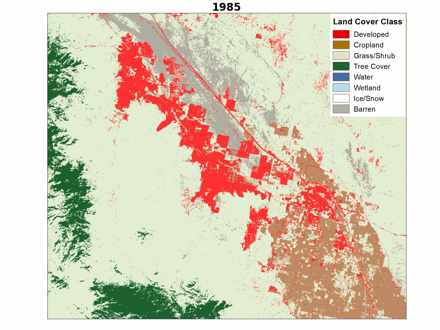
The impact of all that development is evident in the animation below, created using the USGS Land Change Monitoring, Assessment, and Projection (LCMAP) initiative’s Primary Land Cover product. Red represents Developed land; Cropland appears in dark tan.

Watch the space between cities closely, and you’ll see the once-rural setting swallowed up by urban expansion over the 33 years represented in the LCMAP product. By 2017, only a few small patches of cropland and green space remain.
The population of Indianapolis has grown slightly since 1987, but the number of Indianans calling Plainfield home has grown markedly. The 1990 Census figures showed some 10,000 permanent residents for the city. By 2020, estimates put the population at over 35,000.
Related
Explore more LCMAP Change Stories by following the links below.
LCMAP Change Stories LCMAP Change Stories

LCMAP Change Stories: Where the Ocean Eats the Land LCMAP Change Stories: Where the Ocean Eats the Land
LCMAP Change Stories: Building a Boomtown, Block by Block
LCMAP Change Stories: It's a Sprawl World After All

LCMAP Change Stories: Hurricanes in the Everglades

LCMAP Change Stories: Alabama Tornadoes
Related
Explore more LCMAP Change Stories by following the links below.
LCMAP Change Stories LCMAP Change Stories
LCMAP Change Stories: Where the Ocean Eats the Land LCMAP Change Stories: Where the Ocean Eats the Land
LCMAP Change Stories: Building a Boomtown, Block by Block
LCMAP Change Stories: It's a Sprawl World After All
LCMAP Change Stories: Hurricanes in the Everglades