
Daniel J Foley
Daniel Foley is a geographer with the Western Geographic Science Center focused on remote sensing and geospatial analysis of croplands and water use to better understand crop water productivity to mitigate food and water insecurity in the 21st century.
Global Crop Water Productivity and Savings through waterSMART (GCWP)

Increased food production per unit of water or increasing water productivity (or “more crop per drop”; kg/m3) is expected to lead to a “blue revolution” in agriculture making a major contribution to global food and water security in the twenty-first century.
Global Food Security-Support Analysis Data at 30 m (GFSAD)
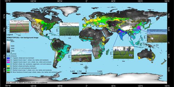
The GFSAD30 is a NASA funded project to provide high resolution global cropland data and their water use that contributes towards global food security in the twenty-first century. The GFSAD30 products are derived through multi-sensor remote sensing data (e.g., Landsat, MODIS, AVHRR), secondary data, and field-plot data and aims at documenting cropland dynamics.
Daniel Foley’s research interests include utilizing GIS, geospatial technology, and remote sensing to solve problems in Earth and environmental science. His research goals are to help better understand modeling and mapping of global croplands for food and water security in the 21st century. Daniel is interested in all aspects of Earth science and education staying up to date in interdisciplinary research techniques and developments. Daniel is active in communication of science with various public speaking roles while giving talks at several conferences and symposiums including an invited talk at the Geo For Good Summit held at Google in 2022 in and winning best presentation award at the International Conference on Water Security and Management in 2021. Currently Daniel’s research focus is on crop water productivity (“crop per drop”) analyzing major world and high-water consuming crops using multi-sensor remote sensing and cloud computing Within this focus he performs Evapotranspiration (ET) and Crop Water Productivity (CWP) studies of leading world crops in the Central Valley of California developing remote sensing methodologies.
Prior to working at the USGS full time he worked for NASA as a Research Analyst in mission operations for the Lunar Reconnaissance Orbiter Camera at Arizona State University (ASU). In addition to research, he has worked in higher education as an instructor of geology, geography and geospatial technology, and Earth and Space Science at various institutions including Grand Canyon University, Northland Pioneer College, and Northern Arizona University (NAU).
Daniel has a Master of Science (M.S.) in Applied Geospatial Sciences and a graduate certificate in Geographic Information Systems (GIS) from NAU. Before this Daniel earned a B.S. in Geological Sciences with a minor in Russian from ASU while completing geology field courses with James Cook University in Australia. He further gained a M.S. from the School of Earth and Space Exploration at ASU was on the tectonic geomorphology and thermochronology of the Transantarctic Mountains taking an integrated field, laboratory, and remote sensing approach. During this time he also worked field seasons for the Barrow Arctic Science Consortium conducting climate change research and for a NASA funded Astrobiology group in Yellowstone National Park conducting high precision geochemical surveys and analysis. He enjoys applying field methods to research and has done extensive geologic and geographic fieldwork that has taken him to remote corners world from the Arctic to the Antarctic. He also has a background in planetary geology research as an undergraduate NASA Space Grant Intern working at the NASA Ames Research Center and the Jet Propulsion Laboratory having been a member of the Mars Exploration Rovers science team and worked with various Mars orbiter spacecraft data including the European Space Agency’s Mars Express.
Science and Products

Global Crop Water Productivity and Savings through waterSMART (GCWP)

Global Food-and-Water Security-support Analysis Data (GFSAD)

Global Hyperspectral Imaging Spectral-library of Agricultural-Crops & Vegetation (GHISA)
Science and Products
Global Crop Water Productivity and Savings through waterSMART (GCWP)
Global Food-and-Water Security-support Analysis Data (GFSAD)