Michael Como
Michael Como is a supervisory hydrologist with the USGS New York Water Science Center, Coram Program Office.
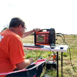
He received his undergraduate degree in Geology from Hofstra University in 2009 and his graduate degree in Hydrogeology from Stony Brook University in 2013. Michael supervises the Coram data section (Coram POD) which collects, analyzes, and disseminates groundwater and surface water data. His background includes groundwater mapping, geophysics, and aquifer test analyses.
Professional Experience
supervisory hydrologist with the USGS New York Water Science Center.
Education and Certifications
MS. in Hydrogeology from Stony Brook University in 2013.
BS. in Geology from Hofstra University in 2009.
Science and Products
Delineation of the freshwater-saltwater interface on southwestern Long Island, New York, through use of surface and borehole geophysical methods Delineation of the freshwater-saltwater interface on southwestern Long Island, New York, through use of surface and borehole geophysical methods
Use of time domain electromagnetic soundings and borehole electromagnetic induction logs to delineate the freshwater/saltwater interface on southwestern Long Island, New York, 2015–17 Use of time domain electromagnetic soundings and borehole electromagnetic induction logs to delineate the freshwater/saltwater interface on southwestern Long Island, New York, 2015–17
Delineation of salt water intrusion through use of electromagnetic-induction logging: A case study in Southern Manhattan Island, New York Delineation of salt water intrusion through use of electromagnetic-induction logging: A case study in Southern Manhattan Island, New York
Delineation of fractures, foliation, and groundwater of the bedrock at a geothermal feasibility site on Roosevelt Island, New York County, New York Delineation of fractures, foliation, and groundwater of the bedrock at a geothermal feasibility site on Roosevelt Island, New York County, New York
Delineation of fractures, foliation, and groundwater-flow zones of the bedrock at the Harlem River Tunnel in northern New York County, New York Delineation of fractures, foliation, and groundwater-flow zones of the bedrock at the Harlem River Tunnel in northern New York County, New York
Preliminary analysis of the hydrologic effects of temporary shutdowns of the Rondout-West Branch Water Tunnel on the groundwater-flow system in Wawarsing, New York Preliminary analysis of the hydrologic effects of temporary shutdowns of the Rondout-West Branch Water Tunnel on the groundwater-flow system in Wawarsing, New York
Non-USGS Publications**
**Disclaimer: The views expressed in Non-USGS publications are those of the author and do not represent the views of the USGS, Department of the Interior, or the U.S. Government.
Saltwater-Interface Mapping - Long Island, New York
Hydrogeologic-Framework Mapping - Long Island, New York
Documenting Hydrogeologic Information Obtained from Deep-Borehole Drilling in Suffolk County, New York
Geospatial Dataset of Water-Table and Potentiometric-Surface Altitudes in the Upper Glacial, Magothy, and Lloyd Aquifers of Long Island, New York, March–April 2006 Geospatial Dataset of Water-Table and Potentiometric-Surface Altitudes in the Upper Glacial, Magothy, and Lloyd Aquifers of Long Island, New York, March–April 2006
Geospatial Dataset of Water-Table and Potentiometric-Surface Altitudes in the Upper Glacial, Magothy, and Lloyd Aquifers of Long Island, New York, April-May 2010 Geospatial Dataset of Water-Table and Potentiometric-Surface Altitudes in the Upper Glacial, Magothy, and Lloyd Aquifers of Long Island, New York, April-May 2010
Horizontal-to-Vertical Spectral Ratio Soundings and Depth-to-Bedrock Data for New York City and Long Island, NY Horizontal-to-Vertical Spectral Ratio Soundings and Depth-to-Bedrock Data for New York City and Long Island, NY
Geospatial Data for Bedrock Elevation and Overburden Thickness Maps of the Five Boroughs, New York City, New York Geospatial Data for Bedrock Elevation and Overburden Thickness Maps of the Five Boroughs, New York City, New York
Time-domain Electromagnetic Soundings to Estimate the Extent of Saltwater Intrusion on Shelter Island, New York (2017-2018) Time-domain Electromagnetic Soundings to Estimate the Extent of Saltwater Intrusion on Shelter Island, New York (2017-2018)
Time Domain Electromagnetic Surveys Collected to Estimate the Extent of Saltwater Intrusion in Nassau and Queens County, New York, October-November 2017 Time Domain Electromagnetic Surveys Collected to Estimate the Extent of Saltwater Intrusion in Nassau and Queens County, New York, October-November 2017
Geospatial Dataset of Water-Table and Potentiometric-Surface Altitudes in the Upper Glacial, Magothy, and Lloyd Aquifers of Long Island, New York, April-May 2016 Geospatial Dataset of Water-Table and Potentiometric-Surface Altitudes in the Upper Glacial, Magothy, and Lloyd Aquifers of Long Island, New York, April-May 2016
Water-table and potentiometric-surface altitudes in the upper glacial, Magothy, and Lloyd aquifers of Long Island, New York, April–May 2016 Water-table and potentiometric-surface altitudes in the upper glacial, Magothy, and Lloyd aquifers of Long Island, New York, April–May 2016
Water-table and potentiometric-surface altitudes in the Upper Glacial, Magothy, and Lloyd aquifers of Long Island, New York, April-May 2013 Water-table and potentiometric-surface altitudes in the Upper Glacial, Magothy, and Lloyd aquifers of Long Island, New York, April-May 2013
Water-table and Potentiometric-surface altitudes in the Upper Glacial, Magothy, and Lloyd aquifers beneath Long Island, New York, April-May 2010 Water-table and Potentiometric-surface altitudes in the Upper Glacial, Magothy, and Lloyd aquifers beneath Long Island, New York, April-May 2010
Science and Products
Delineation of the freshwater-saltwater interface on southwestern Long Island, New York, through use of surface and borehole geophysical methods Delineation of the freshwater-saltwater interface on southwestern Long Island, New York, through use of surface and borehole geophysical methods
Use of time domain electromagnetic soundings and borehole electromagnetic induction logs to delineate the freshwater/saltwater interface on southwestern Long Island, New York, 2015–17 Use of time domain electromagnetic soundings and borehole electromagnetic induction logs to delineate the freshwater/saltwater interface on southwestern Long Island, New York, 2015–17
Delineation of salt water intrusion through use of electromagnetic-induction logging: A case study in Southern Manhattan Island, New York Delineation of salt water intrusion through use of electromagnetic-induction logging: A case study in Southern Manhattan Island, New York
Delineation of fractures, foliation, and groundwater of the bedrock at a geothermal feasibility site on Roosevelt Island, New York County, New York Delineation of fractures, foliation, and groundwater of the bedrock at a geothermal feasibility site on Roosevelt Island, New York County, New York
Delineation of fractures, foliation, and groundwater-flow zones of the bedrock at the Harlem River Tunnel in northern New York County, New York Delineation of fractures, foliation, and groundwater-flow zones of the bedrock at the Harlem River Tunnel in northern New York County, New York
Preliminary analysis of the hydrologic effects of temporary shutdowns of the Rondout-West Branch Water Tunnel on the groundwater-flow system in Wawarsing, New York Preliminary analysis of the hydrologic effects of temporary shutdowns of the Rondout-West Branch Water Tunnel on the groundwater-flow system in Wawarsing, New York
Non-USGS Publications**
**Disclaimer: The views expressed in Non-USGS publications are those of the author and do not represent the views of the USGS, Department of the Interior, or the U.S. Government.


