
Temporary webcam deployed on the boardwalk in Biscuit Basin, Yellowstone National Park. The pan/tilt/zoom camera provides a static view every 15 minutes and records video on site for later download as needed. Black Diamond Pool, site of a hydrothermal explosion on July 23, 2024, is in the background. This work was completed under Yellowstone Nation
Michael Poland
Mike Poland is a research geophysicist with the Cascades Volcano Observatory and the current Scientist-in-Charge of the Yellowstone Volcano Observatory.
Mike's area of specialization is volcano geodesy, which emphasizes the surface deformation and gravity fields associated with volcanic activity. This work involves the use of space-based technologies, like Interferometric Synthetic Aperture Radar (InSAR), as well as ground-based techniques, like microgravity surveys. Mike has taken part in studies on a variety of volcanic systems in the United States, including Mount St. Helens and other volcanoes of the Pacific Northwest, Kilauea and Mauna Loa volcanoes in Hawaii, and the Yellowstone caldera. His recent work has focused on using gravity change over time to understand the character of the fluids that drive volcanic unrest, and also on the potential of satellite data to improve forecasts of future changes in volcanic activity.
Science and Products
Filter Total Items: 159

Biscuit Basin webcam temporary deployment
Temporary webcam deployed on the boardwalk in Biscuit Basin, Yellowstone National Park. The pan/tilt/zoom camera provides a static view every 15 minutes and records video on site for later download as needed. Black Diamond Pool, site of a hydrothermal explosion on July 23, 2024, is in the background. This work was completed under Yellowstone Nation
New hydrothermal feature near "Tree Island" in Norris Geyser Basin, Yellowstone National Park
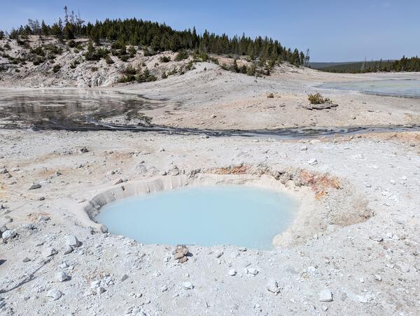
New hydrothermal feature near "Tree Island" in Norris Geyser Basin, Yellowstone National ParkView looking northwest at a new thermal pool in the Porcelain Basin area of Norris Geyser Basin, Yellowstone National Park, that probably formed in a series of mildly explosive events between late December 2024 and early February 2025. The rocks and white material (silica mud) surrounding the pool were probably ejected as the feature formed. The pool is
New hydrothermal feature near "Tree Island" in Norris Geyser Basin, Yellowstone National Park
New hydrothermal feature near "Tree Island" in Norris Geyser Basin, Yellowstone National ParkView looking northwest at a new thermal pool in the Porcelain Basin area of Norris Geyser Basin, Yellowstone National Park, that probably formed in a series of mildly explosive events between late December 2024 and early February 2025. The rocks and white material (silica mud) surrounding the pool were probably ejected as the feature formed. The pool is
")
Finding Lava Flows in Yellowstone (Yellowstone Monthly Update – May 2025)
Finding Lava Flows in Yellowstone (Yellowstone Monthly Update – May 2025)If you want to find a lava flow in Yellowstone, look to the trees! The vegetation is telling us more than you might think.
YVO Scientist-in-Charge Mike Poland reveals how vegetation can be used to map geology in this month's update from the Yellowstone Volcano Observatory.
")
Hoodoo Hodunit?! (Yellowstone Monthly Update – April 2025)
Hoodoo Hodunit?! (Yellowstone Monthly Update – April 2025)Well look at this mess! What’s going on?
We’re just south of Mammoth Hot Springs at a place informally known as the Hoodoos. The official designation for the area is Silver Gate, named by an early Yellowstone National Park visitor because of the way the road wound between the closely spaced white and gray boulders.
")
"I'm Melting!" So are the streets at Yellowstone (Yellowstone Monthly Update - March 2025)
"I'm Melting!" So are the streets at Yellowstone (Yellowstone Monthly Update - March 2025)Is it true roads in Yellowstone National Park are melting? Whatever you might have heard, it's nothing new and it's not due to increased volcanic activity. Get up-to-speed in this month's update from the Yellowstone Volcano Observatory (March 2025).
")
Underwater Smokers in Yellowstone? (Yellowstone Monthly Update - Feb 2025)
Underwater Smokers in Yellowstone? (Yellowstone Monthly Update - Feb 2025)You've probably seen videos of black smokers on the ocean floor, where hydrothermal fluids vent from chimneys. In Yellowstone’s Monument Geyser Basin, you can see similar features right at the surface, and they likely formed in much the same way. Watch to learn more.
")
Top 5 Yellowstone Stories of 2024 (Yellowstone Monthly Update - Jan 2025)
Top 5 Yellowstone Stories of 2024 (Yellowstone Monthly Update - Jan 2025)In addition to the December 2024 update, Mike Poland, scientist-in-charge of the Yellowstone Volcano Observatory, presents YVO’s top five geologic stories from Yellowstone National Park in 2024.

Map of earthquakes in the Yellowstone National Park region in 2024
Map of earthquakes in the Yellowstone National Park region in 2024Map of seismicity (red circles) in the Yellowstone region during 2024. Gray lines are roads, black dashed line shows the caldera boundary, Yellowstone National Park is outlined by black dot-dashed line, and gray dashed lines denote state boundaries.
Organizational chart for the Yellowstone Volcano Observatory in the event of a response to a geological hazard
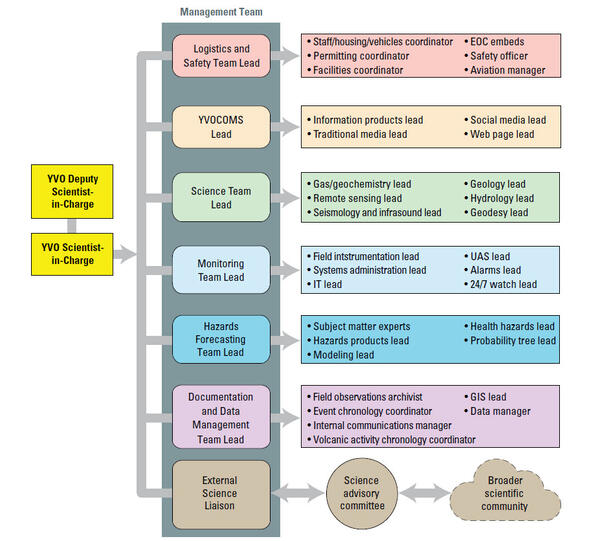
Organizational chart for the Yellowstone Volcano Observatory in the event of a response to a geological hazardOrganization chart giving the structure of a response by the Yellowstone Volcano Observatory to a significant episode of unrest or eruption at the Yellowstone volcanic system. The strategy is scalable (elements are activated as they are needed and deactivated when they are no longer needed) and can be adapted to meet the needs of the event response.
Organizational chart for the Yellowstone Volcano Observatory in the event of a response to a geological hazard
Organizational chart for the Yellowstone Volcano Observatory in the event of a response to a geological hazardOrganization chart giving the structure of a response by the Yellowstone Volcano Observatory to a significant episode of unrest or eruption at the Yellowstone volcanic system. The strategy is scalable (elements are activated as they are needed and deactivated when they are no longer needed) and can be adapted to meet the needs of the event response.
")
Hydrothermal Explosions — more common than you think! (Yellowstone Monthly Update - Dec 2024)
Hydrothermal Explosions — more common than you think! (Yellowstone Monthly Update - Dec 2024)The hydrothermal explosion in Biscuit Basin stole all the headlines. But did you know there was a smaller hydrothermal explosion in Norris Geyser Basin on April 15, 2024? That explosion was detected by a new infrasound sensor installed this past September. Watch to learn more.
")
Obsidian: Not just a valuable commodity in Minecraft. (Yellowstone Monthly Update - November 2024)
Obsidian: Not just a valuable commodity in Minecraft. (Yellowstone Monthly Update - November 2024)Obsidian: It’s not just a valuable commodity in Minecraft. Obsidian was an important resource for Indigenous peoples across western North America. Learn more in this month's update.

Benchmark C9, near Apollinaris Spring in Yellowstone National Park
Benchmark C9, near Apollinaris Spring in Yellowstone National ParkBenchmark C9, installed by the US Coast and Geodetic Survey (now the National Geodetic Survey) in 1923 near Apollinaris Spring in Yellowstone National Park. The number stamped into the mark, “7337.580,” is the elevation in feet that was determined by surveys the year the benchmark was established. USGS photo by Michael Poland, September 4, 2024.
")
Is there oil in Yellowstone? (Yellowstone Monthly Update - September 2024)
Is there oil in Yellowstone? (Yellowstone Monthly Update - September 2024)Is it true that there's oil in Yellowstone? Watch this month's Yellowstone Monthly update and find out.
Is there oil in Yellowstone? (Yellowstone Monthly Update - September 2024)
Is there oil in Yellowstone? (Yellowstone Monthly Update - September 2024)Is it true that there's oil in Yellowstone? Watch this month's Yellowstone Monthly update and find out.

Dead trees along the edge of Nuphar Lake, Yellowstone National Park, in summer 2024
Dead trees along the edge of Nuphar Lake, Yellowstone National Park, in summer 2024Photo of dead trees along the edge of Nuphar Lake. The white staining at the base of the trees is a telltale sign that the trees were immersed in thermal water containing silica. USGS photo by Mike Poland, September 1, 2024.

New steam vent that formed in 2024 near Nymph Lake, Yellowstone National Park
New steam vent that formed in 2024 near Nymph Lake, Yellowstone National ParkNew steam vent at the base of a hill north of Nymph Lake, west of the highway and between Norris Geyser Basin and Roaring Mountain. USGS photo by Mike Poland, September 1, 2024.

new thermal feature that formed in 2024 near Nymph Lake, Yellowstone National Park
new thermal feature that formed in 2024 near Nymph Lake, Yellowstone National ParkLooking south from near a pullout along the Mammoth to Norris road just north of the Nymph Lake overlook. On the other side of the marsh is a tree-covered rhyolite lava flow, and at the base of the flow is a new thermal feature marked by a plume of steam and that formed in early August 2024. Photo by Mike Poland, USGS, September 1, 2024.
Gibbon River near Norris Geyser Basin in Yellowstone National Park
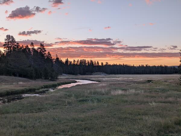
Gibbon River near Norris Geyser Basin in Yellowstone National ParkGibbon River near Norris Geyser Basin in Yellowstone National Park at sunset. USGS Photo by Mike Poland, August 28, 2024.
Gibbon River near Norris Geyser Basin in Yellowstone National Park
Gibbon River near Norris Geyser Basin in Yellowstone National ParkGibbon River near Norris Geyser Basin in Yellowstone National Park at sunset. USGS Photo by Mike Poland, August 28, 2024.
Plot of size versus annual probability for hydrothermal explosion craters in Yellowstone National Park
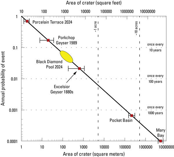
Plot of size versus annual probability for hydrothermal explosion craters in Yellowstone National ParkPlot of size versus annual probability for hydrothermal explosion craters in Yellowstone National Park. The line is a model based on the energy required to form a crater of a specific size, and it is fit to known hydrothermal explosion craters in Yellowstone National Park.
Plot of size versus annual probability for hydrothermal explosion craters in Yellowstone National Park
Plot of size versus annual probability for hydrothermal explosion craters in Yellowstone National ParkPlot of size versus annual probability for hydrothermal explosion craters in Yellowstone National Park. The line is a model based on the energy required to form a crater of a specific size, and it is fit to known hydrothermal explosion craters in Yellowstone National Park.
")
Biscuit Basin Update; 65th Anniversary — M7.3 Hebgen Lake Quake (Yellowstone Monthly Update - Aug 2024)
Biscuit Basin Update; 65th Anniversary — M7.3 Hebgen Lake Quake (Yellowstone Monthly Update - Aug 2024)In this month's video, we update you on the Biscuit Basin explosion on July 23, 2024, and discuss the 65th anniversary of the M7.3 Hegben Lake earthquake.

Satellite images of Biscuit Basin, Yellowstone National Park, before and after the July 23, 2024, hydrothermal explosion
Satellite images of Biscuit Basin, Yellowstone National Park, before and after the July 23, 2024, hydrothermal explosionThese satellite images, acquired by Planet, show Biscuit Basin, Yellowstone National Park, before and after the July 23, 2024, hydrothermal explosion. The before image is from July 21, 2024, and the after image is from July 24, 2024.
")
Hydrothermal Explosion in Yellowstone's Biscuit Basin (July 23, 2024)
Hydrothermal Explosion in Yellowstone's Biscuit Basin (July 23, 2024)What just happened at Biscuit Basin in Yellowstone National Park? Kaboom! Visitors witnessed a towering plume of steam, rock and mud rise several hundred feet into the air. The brief July 23 event was a classic example of a hydrothermal explosion, not a volcanic eruption.
Science and Products
Filter Total Items: 159
Biscuit Basin webcam temporary deployment
Temporary webcam deployed on the boardwalk in Biscuit Basin, Yellowstone National Park. The pan/tilt/zoom camera provides a static view every 15 minutes and records video on site for later download as needed. Black Diamond Pool, site of a hydrothermal explosion on July 23, 2024, is in the background. This work was completed under Yellowstone Nation
Temporary webcam deployed on the boardwalk in Biscuit Basin, Yellowstone National Park. The pan/tilt/zoom camera provides a static view every 15 minutes and records video on site for later download as needed. Black Diamond Pool, site of a hydrothermal explosion on July 23, 2024, is in the background. This work was completed under Yellowstone Nation
New hydrothermal feature near "Tree Island" in Norris Geyser Basin, Yellowstone National Park
New hydrothermal feature near "Tree Island" in Norris Geyser Basin, Yellowstone National ParkView looking northwest at a new thermal pool in the Porcelain Basin area of Norris Geyser Basin, Yellowstone National Park, that probably formed in a series of mildly explosive events between late December 2024 and early February 2025. The rocks and white material (silica mud) surrounding the pool were probably ejected as the feature formed. The pool is
Finding Lava Flows in Yellowstone (Yellowstone Monthly Update – May 2025)
Finding Lava Flows in Yellowstone (Yellowstone Monthly Update – May 2025)If you want to find a lava flow in Yellowstone, look to the trees! The vegetation is telling us more than you might think.
YVO Scientist-in-Charge Mike Poland reveals how vegetation can be used to map geology in this month's update from the Yellowstone Volcano Observatory.
Hoodoo Hodunit?! (Yellowstone Monthly Update – April 2025)
Hoodoo Hodunit?! (Yellowstone Monthly Update – April 2025)Well look at this mess! What’s going on?
We’re just south of Mammoth Hot Springs at a place informally known as the Hoodoos. The official designation for the area is Silver Gate, named by an early Yellowstone National Park visitor because of the way the road wound between the closely spaced white and gray boulders.
"I'm Melting!" So are the streets at Yellowstone (Yellowstone Monthly Update - March 2025)
"I'm Melting!" So are the streets at Yellowstone (Yellowstone Monthly Update - March 2025)Is it true roads in Yellowstone National Park are melting? Whatever you might have heard, it's nothing new and it's not due to increased volcanic activity. Get up-to-speed in this month's update from the Yellowstone Volcano Observatory (March 2025).
Underwater Smokers in Yellowstone? (Yellowstone Monthly Update - Feb 2025)
Underwater Smokers in Yellowstone? (Yellowstone Monthly Update - Feb 2025)You've probably seen videos of black smokers on the ocean floor, where hydrothermal fluids vent from chimneys. In Yellowstone’s Monument Geyser Basin, you can see similar features right at the surface, and they likely formed in much the same way. Watch to learn more.
Top 5 Yellowstone Stories of 2024 (Yellowstone Monthly Update - Jan 2025)
Top 5 Yellowstone Stories of 2024 (Yellowstone Monthly Update - Jan 2025)In addition to the December 2024 update, Mike Poland, scientist-in-charge of the Yellowstone Volcano Observatory, presents YVO’s top five geologic stories from Yellowstone National Park in 2024.
Map of earthquakes in the Yellowstone National Park region in 2024
Map of earthquakes in the Yellowstone National Park region in 2024Map of seismicity (red circles) in the Yellowstone region during 2024. Gray lines are roads, black dashed line shows the caldera boundary, Yellowstone National Park is outlined by black dot-dashed line, and gray dashed lines denote state boundaries.
Organizational chart for the Yellowstone Volcano Observatory in the event of a response to a geological hazard
Organizational chart for the Yellowstone Volcano Observatory in the event of a response to a geological hazardOrganization chart giving the structure of a response by the Yellowstone Volcano Observatory to a significant episode of unrest or eruption at the Yellowstone volcanic system. The strategy is scalable (elements are activated as they are needed and deactivated when they are no longer needed) and can be adapted to meet the needs of the event response.
Hydrothermal Explosions — more common than you think! (Yellowstone Monthly Update - Dec 2024)
Hydrothermal Explosions — more common than you think! (Yellowstone Monthly Update - Dec 2024)The hydrothermal explosion in Biscuit Basin stole all the headlines. But did you know there was a smaller hydrothermal explosion in Norris Geyser Basin on April 15, 2024? That explosion was detected by a new infrasound sensor installed this past September. Watch to learn more.
Obsidian: Not just a valuable commodity in Minecraft. (Yellowstone Monthly Update - November 2024)
Obsidian: Not just a valuable commodity in Minecraft. (Yellowstone Monthly Update - November 2024)Obsidian: It’s not just a valuable commodity in Minecraft. Obsidian was an important resource for Indigenous peoples across western North America. Learn more in this month's update.
Benchmark C9, near Apollinaris Spring in Yellowstone National Park
Benchmark C9, near Apollinaris Spring in Yellowstone National ParkBenchmark C9, installed by the US Coast and Geodetic Survey (now the National Geodetic Survey) in 1923 near Apollinaris Spring in Yellowstone National Park. The number stamped into the mark, “7337.580,” is the elevation in feet that was determined by surveys the year the benchmark was established. USGS photo by Michael Poland, September 4, 2024.
Is there oil in Yellowstone? (Yellowstone Monthly Update - September 2024)
Is there oil in Yellowstone? (Yellowstone Monthly Update - September 2024)Is it true that there's oil in Yellowstone? Watch this month's Yellowstone Monthly update and find out.
Is there oil in Yellowstone? (Yellowstone Monthly Update - September 2024)
Is there oil in Yellowstone? (Yellowstone Monthly Update - September 2024)Is it true that there's oil in Yellowstone? Watch this month's Yellowstone Monthly update and find out.
Dead trees along the edge of Nuphar Lake, Yellowstone National Park, in summer 2024
Dead trees along the edge of Nuphar Lake, Yellowstone National Park, in summer 2024Photo of dead trees along the edge of Nuphar Lake. The white staining at the base of the trees is a telltale sign that the trees were immersed in thermal water containing silica. USGS photo by Mike Poland, September 1, 2024.
New steam vent that formed in 2024 near Nymph Lake, Yellowstone National Park
New steam vent that formed in 2024 near Nymph Lake, Yellowstone National ParkNew steam vent at the base of a hill north of Nymph Lake, west of the highway and between Norris Geyser Basin and Roaring Mountain. USGS photo by Mike Poland, September 1, 2024.
new thermal feature that formed in 2024 near Nymph Lake, Yellowstone National Park
new thermal feature that formed in 2024 near Nymph Lake, Yellowstone National ParkLooking south from near a pullout along the Mammoth to Norris road just north of the Nymph Lake overlook. On the other side of the marsh is a tree-covered rhyolite lava flow, and at the base of the flow is a new thermal feature marked by a plume of steam and that formed in early August 2024. Photo by Mike Poland, USGS, September 1, 2024.
Gibbon River near Norris Geyser Basin in Yellowstone National Park
Gibbon River near Norris Geyser Basin in Yellowstone National ParkGibbon River near Norris Geyser Basin in Yellowstone National Park at sunset. USGS Photo by Mike Poland, August 28, 2024.
Gibbon River near Norris Geyser Basin in Yellowstone National Park
Gibbon River near Norris Geyser Basin in Yellowstone National ParkGibbon River near Norris Geyser Basin in Yellowstone National Park at sunset. USGS Photo by Mike Poland, August 28, 2024.
Plot of size versus annual probability for hydrothermal explosion craters in Yellowstone National Park
Plot of size versus annual probability for hydrothermal explosion craters in Yellowstone National ParkPlot of size versus annual probability for hydrothermal explosion craters in Yellowstone National Park. The line is a model based on the energy required to form a crater of a specific size, and it is fit to known hydrothermal explosion craters in Yellowstone National Park.
Biscuit Basin Update; 65th Anniversary — M7.3 Hebgen Lake Quake (Yellowstone Monthly Update - Aug 2024)
Biscuit Basin Update; 65th Anniversary — M7.3 Hebgen Lake Quake (Yellowstone Monthly Update - Aug 2024)In this month's video, we update you on the Biscuit Basin explosion on July 23, 2024, and discuss the 65th anniversary of the M7.3 Hegben Lake earthquake.
Satellite images of Biscuit Basin, Yellowstone National Park, before and after the July 23, 2024, hydrothermal explosion
Satellite images of Biscuit Basin, Yellowstone National Park, before and after the July 23, 2024, hydrothermal explosionThese satellite images, acquired by Planet, show Biscuit Basin, Yellowstone National Park, before and after the July 23, 2024, hydrothermal explosion. The before image is from July 21, 2024, and the after image is from July 24, 2024.
Hydrothermal Explosion in Yellowstone's Biscuit Basin (July 23, 2024)
Hydrothermal Explosion in Yellowstone's Biscuit Basin (July 23, 2024)What just happened at Biscuit Basin in Yellowstone National Park? Kaboom! Visitors witnessed a towering plume of steam, rock and mud rise several hundred feet into the air. The brief July 23 event was a classic example of a hydrothermal explosion, not a volcanic eruption.
*Disclaimer: Listing outside positions with professional scientific organizations on this Staff Profile are for informational purposes only and do not constitute an endorsement of those professional scientific organizations or their activities by the USGS, Department of the Interior, or U.S. Government