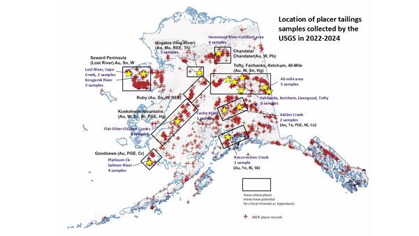
Map showing locations of placer mines in the Alaska Resource Data File (ARDF, red crosses), primary mineral districts that contain targeted critical minerals (black boxes) and locations that were sampled by the USGS in 2022 and 2023 (yellow stars).
Susan Karl
Sedimentology, stratigraphy, tectonics, geochemistry, and economic geology of southeast Alaska
Professional Experience
1977 - Present Research Geologist, USGS Alaska Science Center, Anchorage, AK
1976 Earth Science Associates, Palo Alto, CA
1975 WGM Inc., Brooks Range, AK
1974 Rio Tinto Ltd., Wrangell Mts, AK
Education and Certifications
Ph.D. 1982 Stanford University
Classes 1975-1976 University of Alaska Fairbanks
B.A. 1973 Middlebury College
Affiliations and Memberships*
Fellow: Geological Soc. America
Member: American Geophysical Union, American Assoc. Petrol. Geol., Geological Assoc. Canada, Society of Economic Geologists
Short course committee chair: Alaska Miners Association
Board member, committee chair, past president, officer: Alaska Geological Society
Honors and Awards
Amer. Assoc. Petroleum Geologists: Lifetime service award, May 2016, for contributions to the Alaska geological community
Outstanding Accomplishment award 11-18-2011 for contributions to understanding REE in southeast Alaska
Outstanding Accomplishment award 11-22-2010 for advances in southeast Alaska geology
Outstanding Accomplishment award 9-22-2009 for work with Yukon Territory, British Columbia, and Alaskan geologists to coordinate cross-border geology
USGS: STAR award 1999 for Stikine area geophysical survey follow-up project (Duncan Canal/Zarembo Island area VMS deposits)
Alaska Geol. Soc: Service award, 1995
UNESCO: Grant for IGCP Siliceous Deposits Conference (Yugoslavia), 1986
USGS: Graduate internship scholarship 1981, 1982
UNESCO: Grant for IGCP Siliceous Deposits Conference (Tokyo), 1981
Geol. Soc. America: Grant for thesis research 1981
Sigma Xi: Grant for thesis research, 1980, 1981
USGS Achievement Award 1979
Shell: Grant for Melange Penrose Conference, 1978
Geol. Soc. Amer: Harold Stearns Award and grant for thesis research, 1978
UAF: grant for field camp 1976
Science and Products
Alaska Mine Waste
Critical Minerals in Alaska Placer Deposits and Southeast Alaska Mineral Systems
Alaska Critical Mineral Resource Assessments
GIS Prospectivity Analysis for Critical Minerals in Ore-Forming Systems in Alaska
Petrology, Tectonic Setting, and Potential for Concentration of Rare Earth Elements (REE) and High Field Strength Elements (HFSE) in the High-K Darby and Kachauik Plutons, Seward Peninsula, Alaska
Data for Uranium-Lead Geochronology, Carbon and Sulfur Stable Isotopes, and Raman Spectroscopy from Graphite Creek, Alaska
Whole Rock Major and Trace Element Chemistry for Igneous Rocks from Tyonek, Lime Hills, Talkeetna, McGrath, and Lake Clark Quadrangles, Western Alaska Range, Alaska
Whole Rock Major and Trace Element Chemistry for Igneous and Sedimentary Rocks from the Western Alaska Range, Alaska
Data from the Chemical Analysis of Archived Stream-Sediment Samples, Alaska
Data and results for GIS-based identification of areas that have resource potential for lode gold deposits in Alaska
Geochemical and 40Ar/39Ar Analytical Data of Rocks from Glacier Bay National Park and Preserve
U-Pb Isotopic Data and Ages of Zircon and Titanite from Rocks from the Western Alaska Range, Northern Aleutian Range, Taylor Mountains, and Tikchik Mountains Regions, Alaska
U-Pb Isotopic Data and Ages of Titanite and Detrital Zircon from Selected Rocks from the Western Alaska Range, Alaska
Alaska Geochemical Database Version 3.0 (AGDB3) including best value data compilations for rock, sediment, soil, mineral, and concentrate sample media
Geologic Map of Baranof Island, southeastern Alaska
Geologic map of Alaska
Geologic map of western Chichagof and Yakobi islands, southeastern Alaska
Map showing locations of placer mines in the Alaska Resource Data File (ARDF, red crosses), primary mineral districts that contain targeted critical minerals (black boxes) and locations that were sampled by the USGS in 2022 and 2023 (yellow stars).
Scientist sieving a sample of gold placer tailings to analyze for critical mineral contents in Uhler Creek, a tributary to the South Fork of the Forty Mile River in east central Alaska.
Scientist sieving a sample of tin placer tailings in Cassiterite Creek on the western Seward Peninsula.
Historic dredge and large volume of gold placer tailings that contain platinum group and chromium critical minerals on the Salmon River near Goodnews Bay, Alaska. Dragline-sluice tailings are in the foreground, stacked dredge tailings are in the background near the dredge.
Scientists collecting a 1/5 yard composite sample in blue 5-gallon buckets from gold placer tailings to analyze for critical mineral contents in Clear Creek, in the Zane Hills north central Alaska.
Scientist checking a gold pan for gold and critical minerals in placer tailings on lower Chicken Creek near Flat, Alaska, in the Kuskokwim Mountains. A sample was collected from legacy gold placer tailings at this site and 7 others in the Flat mining district to determine the critical mineral contents of tailings from which only gold has been removed.
USGS geologist George Case is recording data on graphite mineralization in core sample from the Graphite Creek deposit in Nome, Alaska. The purpose of this research is to determine the genesis and key attributes of the world class large flake Graphite Creek deposit on the western Seward Peninsula, Alaska.
A geologist, George Case, stands in front of an adit, an entrance to an underground mine, in the Graphite Creek Deposit on the Seward Peninsula, Alaska.
View of fog and clouds in the Aaron Creek valley with tail of R66 helicopter in right foreground.
Geologist George Case approaches an old exploration trench exposing stratiform Ag-Sn-Pb-Zn mineralization in the Groundhog Basin deposit area.
Rock hammer shows meter-scale width of a felsic sill associated with zinnwaldite-bearing Sn-granite at the Groundhog Basin Ag-Sn-Pb-Zn deposit. The layered host rocks to the sill are garnet-quartz-biotite gneiss.
USGS geologist George Case approaches an R66 helicopter with samples collected from mineralized rocks near the Groundhog Basin Ag-Sn-Pb-Zn deposit.
USGS geologist George Case breaks mineralized rocks for examination and sample collection at the Groundhog Basin Ag-Sn-Pb-Zn deposit.
USGS Geologist George Case examines granitic rocks in preparation for collecting samples for geochemistry and geochronology near the Boulder Creek prospect at the north end of the Darby pluton on the eastern Seward Peninsula.
Stretched phenocrysts of potassium feldspar in syenite of the Kachauik pluton on the Bering Sea coast of the southeastern Seward Peninsula.
Scintillometer and torrs of the Melozitna granite in the Ruby batholith. This granite contains abundant monazite and high levels of thorium and rare earth elements. This area is part of the Bureau of Land Management's Central Yukon Planning Area, which USGS did a mineral assessment of in 2015.
Geologist and cataclastic shear zones in the Melozitna granite in the Ruby batholith. This granite contains abundant monazite and high levels of thorium and rare earth elements.
USGS researchers collecting a soil sample for rare earth elements at the Roy Creek prospect, Alaska. Jamey Jones is holding the bag while Erin Todd shovels soil into the bag.
A field assistant pans for monazite and rare earth minerals in Wolf Creek, which cuts through the Melozitna granite. This area is part of the Bureau of Land Management's Central Yukon Planning Area, where USGS did a critical mineral assessment in 2015.
Insights into the metamorphic history and origin of flake graphite mineralization at the Graphite Creek graphite deposit, Seward Peninsula, Alaska, USA
Geospatial analysis delineates lode gold prospectivity in Alaska
GIS-based identification of areas that have resource potential for lode gold in Alaska
Chemical analysis of archived stream-sediment samples, Alaska
Cretaceous to Oligocene magmatic and tectonic evolution of the western Alaska Range: Insights from U-Pb and 40Ar/39Ar geochronology
Evaluation of the analytical methods used to determine the elemental concentrations found in the stream geochemical dataset compiled for Alaska
Detrital zircon geochronology along a structural transect across the Kahiltna assemblage in the western Alaska Range: Implications for emplacement of the Alexander-Wrangellia-Peninsular terrane against North America
Alaska Geochemical Database Version 3.0 (AGDB3)—Including “Best Value” Data Compilations for Rock, Sediment, Soil, Mineral, and Concentrate Sample Media
Geospatial analysis identifies critical mineral-resource potential in Alaska
Regional patterns of Mesozoic-Cenozoic magmatism in western Alaska revealed by new U-Pb and 40Ar/39Ar ages
In support of regional geologic framework studies, we obtained 50 new argon-40/argon-39 (40Ar/39Ar) ages and 33 new uranium-lead (U-Pb) ages from igneous rocks of southwestern Alaska. Most of the samples are from the Sleetmute and Taylor Mountains quadrangles; smaller collections or individual samples are from the Bethel, Candle, Dillingham, Goodnews Bay, Holy Cross, Iditarod, Kantishna River, Lak
The Peters Hills basin, a Neogene wedge-top basin on the Broad Pass thrust fault, south-central Alaska
GIS-based identification of areas that have resource potential for critical minerals in six selected groups of deposit types in Alaska
Science and Products
Alaska Mine Waste
Critical Minerals in Alaska Placer Deposits and Southeast Alaska Mineral Systems
Alaska Critical Mineral Resource Assessments
GIS Prospectivity Analysis for Critical Minerals in Ore-Forming Systems in Alaska
Petrology, Tectonic Setting, and Potential for Concentration of Rare Earth Elements (REE) and High Field Strength Elements (HFSE) in the High-K Darby and Kachauik Plutons, Seward Peninsula, Alaska
Data for Uranium-Lead Geochronology, Carbon and Sulfur Stable Isotopes, and Raman Spectroscopy from Graphite Creek, Alaska
Whole Rock Major and Trace Element Chemistry for Igneous Rocks from Tyonek, Lime Hills, Talkeetna, McGrath, and Lake Clark Quadrangles, Western Alaska Range, Alaska
Whole Rock Major and Trace Element Chemistry for Igneous and Sedimentary Rocks from the Western Alaska Range, Alaska
Data from the Chemical Analysis of Archived Stream-Sediment Samples, Alaska
Data and results for GIS-based identification of areas that have resource potential for lode gold deposits in Alaska
Geochemical and 40Ar/39Ar Analytical Data of Rocks from Glacier Bay National Park and Preserve
U-Pb Isotopic Data and Ages of Zircon and Titanite from Rocks from the Western Alaska Range, Northern Aleutian Range, Taylor Mountains, and Tikchik Mountains Regions, Alaska
U-Pb Isotopic Data and Ages of Titanite and Detrital Zircon from Selected Rocks from the Western Alaska Range, Alaska
Alaska Geochemical Database Version 3.0 (AGDB3) including best value data compilations for rock, sediment, soil, mineral, and concentrate sample media
Geologic Map of Baranof Island, southeastern Alaska
Geologic map of Alaska
Geologic map of western Chichagof and Yakobi islands, southeastern Alaska
Map showing locations of placer mines in the Alaska Resource Data File (ARDF, red crosses), primary mineral districts that contain targeted critical minerals (black boxes) and locations that were sampled by the USGS in 2022 and 2023 (yellow stars).
Scientist sieving a sample of gold placer tailings to analyze for critical mineral contents in Uhler Creek, a tributary to the South Fork of the Forty Mile River in east central Alaska.
Scientist sieving a sample of tin placer tailings in Cassiterite Creek on the western Seward Peninsula.
Historic dredge and large volume of gold placer tailings that contain platinum group and chromium critical minerals on the Salmon River near Goodnews Bay, Alaska. Dragline-sluice tailings are in the foreground, stacked dredge tailings are in the background near the dredge.
Scientists collecting a 1/5 yard composite sample in blue 5-gallon buckets from gold placer tailings to analyze for critical mineral contents in Clear Creek, in the Zane Hills north central Alaska.
Scientist checking a gold pan for gold and critical minerals in placer tailings on lower Chicken Creek near Flat, Alaska, in the Kuskokwim Mountains. A sample was collected from legacy gold placer tailings at this site and 7 others in the Flat mining district to determine the critical mineral contents of tailings from which only gold has been removed.
USGS geologist George Case is recording data on graphite mineralization in core sample from the Graphite Creek deposit in Nome, Alaska. The purpose of this research is to determine the genesis and key attributes of the world class large flake Graphite Creek deposit on the western Seward Peninsula, Alaska.
A geologist, George Case, stands in front of an adit, an entrance to an underground mine, in the Graphite Creek Deposit on the Seward Peninsula, Alaska.
View of fog and clouds in the Aaron Creek valley with tail of R66 helicopter in right foreground.
Geologist George Case approaches an old exploration trench exposing stratiform Ag-Sn-Pb-Zn mineralization in the Groundhog Basin deposit area.
Rock hammer shows meter-scale width of a felsic sill associated with zinnwaldite-bearing Sn-granite at the Groundhog Basin Ag-Sn-Pb-Zn deposit. The layered host rocks to the sill are garnet-quartz-biotite gneiss.
USGS geologist George Case approaches an R66 helicopter with samples collected from mineralized rocks near the Groundhog Basin Ag-Sn-Pb-Zn deposit.
USGS geologist George Case breaks mineralized rocks for examination and sample collection at the Groundhog Basin Ag-Sn-Pb-Zn deposit.
USGS Geologist George Case examines granitic rocks in preparation for collecting samples for geochemistry and geochronology near the Boulder Creek prospect at the north end of the Darby pluton on the eastern Seward Peninsula.
Stretched phenocrysts of potassium feldspar in syenite of the Kachauik pluton on the Bering Sea coast of the southeastern Seward Peninsula.
Scintillometer and torrs of the Melozitna granite in the Ruby batholith. This granite contains abundant monazite and high levels of thorium and rare earth elements. This area is part of the Bureau of Land Management's Central Yukon Planning Area, which USGS did a mineral assessment of in 2015.
Geologist and cataclastic shear zones in the Melozitna granite in the Ruby batholith. This granite contains abundant monazite and high levels of thorium and rare earth elements.
USGS researchers collecting a soil sample for rare earth elements at the Roy Creek prospect, Alaska. Jamey Jones is holding the bag while Erin Todd shovels soil into the bag.
A field assistant pans for monazite and rare earth minerals in Wolf Creek, which cuts through the Melozitna granite. This area is part of the Bureau of Land Management's Central Yukon Planning Area, where USGS did a critical mineral assessment in 2015.
Insights into the metamorphic history and origin of flake graphite mineralization at the Graphite Creek graphite deposit, Seward Peninsula, Alaska, USA
Geospatial analysis delineates lode gold prospectivity in Alaska
GIS-based identification of areas that have resource potential for lode gold in Alaska
Chemical analysis of archived stream-sediment samples, Alaska
Cretaceous to Oligocene magmatic and tectonic evolution of the western Alaska Range: Insights from U-Pb and 40Ar/39Ar geochronology
Evaluation of the analytical methods used to determine the elemental concentrations found in the stream geochemical dataset compiled for Alaska
Detrital zircon geochronology along a structural transect across the Kahiltna assemblage in the western Alaska Range: Implications for emplacement of the Alexander-Wrangellia-Peninsular terrane against North America
Alaska Geochemical Database Version 3.0 (AGDB3)—Including “Best Value” Data Compilations for Rock, Sediment, Soil, Mineral, and Concentrate Sample Media
Geospatial analysis identifies critical mineral-resource potential in Alaska
Regional patterns of Mesozoic-Cenozoic magmatism in western Alaska revealed by new U-Pb and 40Ar/39Ar ages
In support of regional geologic framework studies, we obtained 50 new argon-40/argon-39 (40Ar/39Ar) ages and 33 new uranium-lead (U-Pb) ages from igneous rocks of southwestern Alaska. Most of the samples are from the Sleetmute and Taylor Mountains quadrangles; smaller collections or individual samples are from the Bethel, Candle, Dillingham, Goodnews Bay, Holy Cross, Iditarod, Kantishna River, Lak
The Peters Hills basin, a Neogene wedge-top basin on the Broad Pass thrust fault, south-central Alaska
GIS-based identification of areas that have resource potential for critical minerals in six selected groups of deposit types in Alaska
*Disclaimer: Listing outside positions with professional scientific organizations on this Staff Profile are for informational purposes only and do not constitute an endorsement of those professional scientific organizations or their activities by the USGS, Department of the Interior, or U.S. Government