
Drought Intensity Map compiled by the U.S. Drought Monitor for the area of NOAA's Colorado River Basin River Forecast Center, which includes part of the Great Basin drainage area in western Utah, for April 19, 2024.
Images
Images intro.
Filter Total Items: 187

Drought Intensity Map, April 19, 2022
Drought Intensity Map compiled by the U.S. Drought Monitor for the area of NOAA's Colorado River Basin River Forecast Center, which includes part of the Great Basin drainage area in western Utah, for April 19, 2024.

Ecological site group map for the Upper Colorado River Basin
Ecological site group map for the Upper Colorado River BasinAn ecological site group map for the Upper Colorado River Basin that displays a quantitative soil-geomorphic framework in the Four Corners region, USA.
Ecological site group map for the Upper Colorado River Basin
Ecological site group map for the Upper Colorado River BasinAn ecological site group map for the Upper Colorado River Basin that displays a quantitative soil-geomorphic framework in the Four Corners region, USA.

Photo of Zion Canyon (Geology)
Photo of Zion Canyon located in Zion National Park in Utah, United States. (Image courtesy of Justin Gould)
Photo of Zion Canyon located in Zion National Park in Utah, United States. (Image courtesy of Justin Gould)
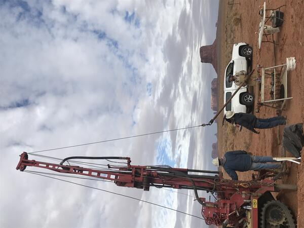
USGS drilling and installing monitoring wells at trench infiltrations site in Monument Valley, Utah, Navajo Nation Reservation, December 8, 2021
USGS drilling and installing monitoring wells at trench infiltrations site in Monument Valley, Utah, Navajo Nation Reservation, December 8, 2021USGS drilling and installing monitoring wells at trench infiltrations site in Monument Valley, Utah, Navajo Nation Reservation, to investigate the feasibility of recharging a groundwater aquifer.

Lichen on rock, Moab, Utah - biocrust study
This photo of lichen was taken by SBSC in Moab, Utah as part of a biocrust study in 2021. Photo courtesy of Erika Geiger, USGS.
This photo of lichen was taken by SBSC in Moab, Utah as part of a biocrust study in 2021. Photo courtesy of Erika Geiger, USGS.

Pack Creek at Pack Creek Road Bridge river gage
Photo looking downstream from the Pack Creek Road Bridge shows the rain gage on top with a USGS sticker. Below is a solar panel for power. The other white round object contains the data logger and satellite antenna.
Photo looking downstream from the Pack Creek Road Bridge shows the rain gage on top with a USGS sticker. Below is a solar panel for power. The other white round object contains the data logger and satellite antenna.

Cathedral Valley, Capital Reef National Park, Utah
Cathedral Valley, Capital Reef National Park, UtahCathedral Valley, Capital Reef National Park, Utah. Photo by Chris Benson, USGS.
Cathedral Valley, Capital Reef National Park, Utah
Cathedral Valley, Capital Reef National Park, UtahCathedral Valley, Capital Reef National Park, Utah. Photo by Chris Benson, USGS.

A panorama of Cathedral Valley, Capital Reef National Park, Utah
A panorama of Cathedral Valley, Capital Reef National Park, UtahA panorama of Cathedral Valley, Capital Reef National Park, Utah. Photo by Chris Benson, USGS, 2021.
A panorama of Cathedral Valley, Capital Reef National Park, Utah
A panorama of Cathedral Valley, Capital Reef National Park, UtahA panorama of Cathedral Valley, Capital Reef National Park, Utah. Photo by Chris Benson, USGS, 2021.

Great Salt Lake Reaches New Historic Low
USGS hydrologic technician Travis Gibson confirms Great Salt Lake water levels at the SaltAire gauge.
USGS hydrologic technician Travis Gibson confirms Great Salt Lake water levels at the SaltAire gauge.

Great Salt Lake Reaches New Historic Low
A sailboat is removed from the Great Salt Lake Marina due to low lake levels.
A sailboat is removed from the Great Salt Lake Marina due to low lake levels.
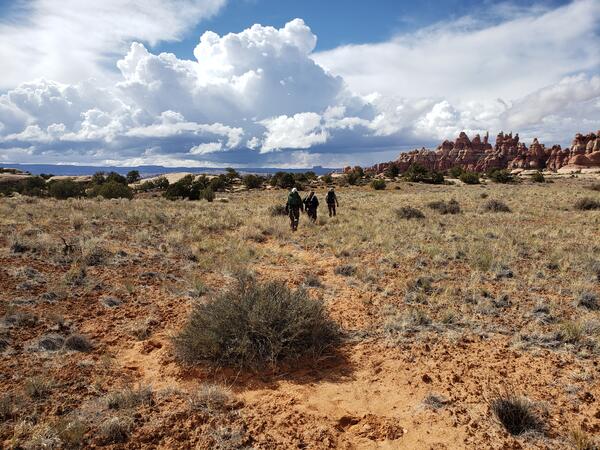
USGS researchers walk to a vegetation and drought study site in Canyonlands National Park, Utah
USGS researchers walk to a vegetation and drought study site in Canyonlands National Park, UtahUSGS researchers walk to a long-term vegetation and drought study site in a Canyonlands National Park grassland, Utah, where long-term monitoring has occurred since 1998.

Vegetation drought research in Canyonlands National Park
Vegetation drought research in Canyonlands National ParkUSGS scientist Dr. Erika Geiger gathers research at a vegetation drought monitoring study in Canyonlands National Park, Utah. Here Dr. Geiger collects data on warm season grasses at a control plot associated with a long-term drought experiment.

3DEP lidar over Millsite Reservoir, UT
3DEP lidar rendering of Millsite Reservoir near Millsite State Park, Utah.
3DEP lidar rendering of Millsite Reservoir near Millsite State Park, Utah.

Cleaning and inspecting water height reference staff at streamgage
Cleaning and inspecting water height reference staff at streamgageUSGS hydrologist Adam Birken cleans and inspects the water height reference staff at the USGS streamgage site on the South Fork of the Ogden River near Hunstville, Utah. This streamgage has been monitoring water levels and flow since March 21, 1921, making it one of 25 centennial gauges in Utah.

Measuring streamflow on the Ogden River near Hunstville, Utah
Measuring streamflow on the Ogden River near Hunstville, UtahUSGS hydrologist Adam Birken prepares to measure streamflow on the South Fork of the Ogden River near Hunstville, Utah. This streamgage has been monitoring water levels and flow since March 21, 1921, making it one of 25 centennial gauges in Utah.

Chart recorder similar to one installed inside a centennial streamgage
Chart recorder similar to one installed inside a centennial streamgageThis is a chart recorder similar to the one installed inside the USGS streamgage on the South Fork of the Ogden River in 1921.
Chart recorder similar to one installed inside a centennial streamgage
Chart recorder similar to one installed inside a centennial streamgageThis is a chart recorder similar to the one installed inside the USGS streamgage on the South Fork of the Ogden River in 1921.

Utah Gauge Celebrates 100 Years of Monitoring Streamflow
Utah Gauge Celebrates 100 Years of Monitoring StreamflowA U.S. Geological Survey streamgage near Hunstville, Utah is celebrating 100 years of monitoring streamflow on the south fork of the Ogden River. The streamgage has been monitoring water levels and flow since March 21, 1921, making it one of 25 centennial gauges in Utah.

USGS hydrologist conducts equipment maintenance at streamgage
USGS hydrologist conducts equipment maintenance at streamgageUSGS hydrologist Adam Birken conducts equipment maintenance at the USGS streamgage on the South Fork of the Ogden River near Hunstville, Utah. This streamgage has been monitoring water levels and flow since March 21, 1921, making it one of 25 centennial gauges in Utah.

Utah Gauge Celebrates 100 Years of Monitoring Streamflow
Utah Gauge Celebrates 100 Years of Monitoring StreamflowA U.S. Geological Survey streamgage near Hunstville, Utah is celebrating 100 years of monitoring streamflow on the south fork of the Ogden River. The streamgage has been monitoring water levels and flow since March 21, 1921, making it one of 25 centennial gauges in Utah.

Chinle Creek, USGS
Photo of Chinle Creek, USGS
Photo of Chinle Creek, USGS

Modern equipment currently in use at a streamgage on the Ogden River
Modern equipment currently in use at a streamgage on the Ogden RiverModern equipment currently in use at the South Fork of the Ogden River streamgage, to include; an electronic data logger, pressure transducer and GOES radio. This streamgage has been monitoring water levels and flow since March 21, 1921, making it one of 25 centennial gauges in Utah. The equipment used to collect data has changed significantly over the pas