



NASA image of Bear Lake with beautiful swirls in blue water showing mixing
Images
Images intro.
Filter Total Items: 192

Bear Lake Mixing
NASA image of Bear Lake with beautiful swirls in blue water showing mixing
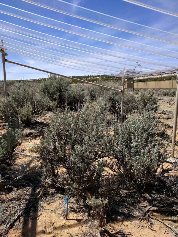
Rainout shelters allow researchers to study the effects of drought
Rainout shelters allow researchers to study the effects of droughtThis rainout shelter blcoks about 35% of the natural rainfall, allowing researchers to understand the effects of drought on plants in the southwestern United States.
Rainout shelters allow researchers to study the effects of drought
Rainout shelters allow researchers to study the effects of droughtThis rainout shelter blcoks about 35% of the natural rainfall, allowing researchers to understand the effects of drought on plants in the southwestern United States.

Rainout shelters allow researchers to study effects of drought
Rainout shelters allow researchers to study effects of droughtRainout shelters block about 35% of natural rainfall, allowing researchers to study the effects of drought on plants in the arid and semiarid southwestern United States.
Rainout shelters allow researchers to study effects of drought
Rainout shelters allow researchers to study effects of droughtRainout shelters block about 35% of natural rainfall, allowing researchers to study the effects of drought on plants in the arid and semiarid southwestern United States.
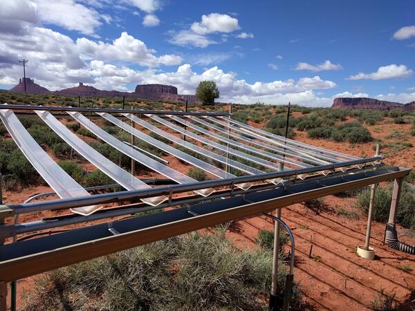
Rainout structures allow researchers to study the effects of drought
Rainout structures allow researchers to study the effects of droughtThis rainout structure blocks about 35% of the natural rainfall, allowing researchers to study the effects of drought on plants in the southwestern United States.
Rainout structures allow researchers to study the effects of drought
Rainout structures allow researchers to study the effects of droughtThis rainout structure blocks about 35% of the natural rainfall, allowing researchers to study the effects of drought on plants in the southwestern United States.

Attribution of storm-weighted potential contaminant hazard ranks
Attribution of storm-weighted potential contaminant hazard ranksGeospatial Analyses and Applications — Salt Lake City, Utah. Attribution of storm-weighted potential contaminant hazard ranks to sampling locations in the Sediment-Bound Contaminant Resiliency and Response (SCoRR) network.
Attribution of storm-weighted potential contaminant hazard ranks
Attribution of storm-weighted potential contaminant hazard ranksGeospatial Analyses and Applications — Salt Lake City, Utah. Attribution of storm-weighted potential contaminant hazard ranks to sampling locations in the Sediment-Bound Contaminant Resiliency and Response (SCoRR) network.

UT WSC Sign
USGS sign on flagstone at the Utah Water Science Center
USGS sign on flagstone at the Utah Water Science Center

Lake Powell
The USGS Utah Water Science Center and the Woods Hole Coastal and Marine Science Center conducted a collaborative geophysical research effort within Lake Powell, UT-AZ to map the bathymetry of the lake and characterize shallow sediment deposition near the mouths of the San Juan and Colorado Rivers.
The USGS Utah Water Science Center and the Woods Hole Coastal and Marine Science Center conducted a collaborative geophysical research effort within Lake Powell, UT-AZ to map the bathymetry of the lake and characterize shallow sediment deposition near the mouths of the San Juan and Colorado Rivers.

Dry wash in San Rafael Desert with white surface salts
Dry wash in San Rafael Desert with white surface saltsDry wash in San Rafael Desert with white surface salts. White efflorescent salts form on the soil surface as water evaporates from the soil leaving the salt at the surface.
Dry wash in San Rafael Desert with white surface salts
Dry wash in San Rafael Desert with white surface saltsDry wash in San Rafael Desert with white surface salts. White efflorescent salts form on the soil surface as water evaporates from the soil leaving the salt at the surface.

Dry, cracked soil (RAMPS)
Rangelands of the desert Southwest can be in a degraded condition and lacking perennial vegetation, which can lead to exposed soil and erosion.
Rangelands of the desert Southwest can be in a degraded condition and lacking perennial vegetation, which can lead to exposed soil and erosion.

Great Salt Lake, USGS boat at work
USGS scientists check breach on glass-calm Great Salt Lake in surreal light.
USGS scientists check breach on glass-calm Great Salt Lake in surreal light.
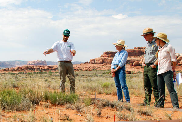
USGS discusses grassland drought research with the National Park Service, BLM and a rancher at Canyonlands National Park
USGS discusses grassland drought research with the National Park Service, BLM and a rancher at Canyonlands National ParkUSGS discusses grassland drought research with the National Park Service, BLM and a rancher at Canyonlands National Park.
USGS discusses grassland drought research with the National Park Service, BLM and a rancher at Canyonlands National Park
USGS discusses grassland drought research with the National Park Service, BLM and a rancher at Canyonlands National ParkUSGS discusses grassland drought research with the National Park Service, BLM and a rancher at Canyonlands National Park.

USGS discusses rangeland conditions and drought with managers and partners on the Colorado Plateau
USGS discusses rangeland conditions and drought with managers and partners on the Colorado PlateauThe USGS Southwest Biological Science Center discusses rangeland conditions and our research on drought with managers and partners on the Colorado Plateau. Photo courtesy of Mike Duniway, USGS.
USGS discusses rangeland conditions and drought with managers and partners on the Colorado Plateau
USGS discusses rangeland conditions and drought with managers and partners on the Colorado PlateauThe USGS Southwest Biological Science Center discusses rangeland conditions and our research on drought with managers and partners on the Colorado Plateau. Photo courtesy of Mike Duniway, USGS.

Setting up experimental restoration plots.
Field crew install a Restoration Field Trial Network garden in the rangelands of Northern Arizona.
Field crew install a Restoration Field Trial Network garden in the rangelands of Northern Arizona.

Fires in the Western United States
On an average day during the fire season, multiple wildfires burn in the western United States. For example, 216 fires were active on July 7, 2017. Firefighters were battling 27 of these fires through ground and air support.
On an average day during the fire season, multiple wildfires burn in the western United States. For example, 216 fires were active on July 7, 2017. Firefighters were battling 27 of these fires through ground and air support.

USGS research boat conducting science on the Great Salt Lake.
USGS research boat conducting science on the Great Salt Lake.USGS scientist Robert Baskin takes a boat out on the Great Salt Lake to conduct research.
USGS research boat conducting science on the Great Salt Lake.
USGS research boat conducting science on the Great Salt Lake.USGS scientist Robert Baskin takes a boat out on the Great Salt Lake to conduct research.

Biocrusts in healthy grassland data collection
Person taking data in a healthy dryland grassland with dark biocrusts between bunchgrasses and cacti in Utah.
Person taking data in a healthy dryland grassland with dark biocrusts between bunchgrasses and cacti in Utah.


View from Canyonlands Research Center
View from Canyonlands Research Center.

Biocrust
On the Colorado Plateau, mature biocrusts are bumpy and dark-colored due to the presence of lichens, mosses, and high densities of cyanobacteria and other organisms. Disturbed biocrusts are lighter in color, looking more like the underlying sand than undisturbed ones, and are less capable of stabilizing soils or providing soil fertility.
On the Colorado Plateau, mature biocrusts are bumpy and dark-colored due to the presence of lichens, mosses, and high densities of cyanobacteria and other organisms. Disturbed biocrusts are lighter in color, looking more like the underlying sand than undisturbed ones, and are less capable of stabilizing soils or providing soil fertility.

USGS scientist Jayne Belnap examines instruments to measure biocrust
USGS scientist Jayne Belnap examines instruments to measure biocrustUSGS scientist Jayne Belnap examines instrumentation to measure photosynthetic rates of biocrusts.
USGS scientist Jayne Belnap examines instruments to measure biocrust
USGS scientist Jayne Belnap examines instruments to measure biocrustUSGS scientist Jayne Belnap examines instrumentation to measure photosynthetic rates of biocrusts.

Footprint damage to biocrusts
Many human activities can be unintentionally harmful to biological crusts. The biocrusts are no match for the compressional stress caused by footprints of livestock or people or tracks from vehicles.
Many human activities can be unintentionally harmful to biological crusts. The biocrusts are no match for the compressional stress caused by footprints of livestock or people or tracks from vehicles.