GeoGirls Hike the Pumice Plain at Mount St. Helens
GeoGirls Hike the Pumice Plain at Mount St. HelensThe GeoGirls hike the Pumice Plain at Mount St. Helens, examining lava outcrops and volcanic sediment.

Official websites use .gov
A .gov website belongs to an official government organization in the United States.
Secure .gov websites use HTTPS
A lock () or https:// means you’ve safely connected to the .gov website. Share sensitive information only on official, secure websites.

The GeoGirls hike the Pumice Plain at Mount St. Helens, examining lava outcrops and volcanic sediment.
The GeoGirls hike the Pumice Plain at Mount St. Helens, examining lava outcrops and volcanic sediment.

GeoGirls venture into Ape Cave, a 2,000-year-old lava tube on the south flank of Mount St. Helens, as they learn about Mount St. Helens’ eruptive history and lava flows.
GeoGirls venture into Ape Cave, a 2,000-year-old lava tube on the south flank of Mount St. Helens, as they learn about Mount St. Helens’ eruptive history and lava flows.
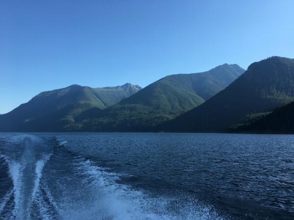
Evening shot of Ross Lake with boat wake. Heading back to camp after a day of research. Ross Lake is a large reservoir in the North Cascade mountains of northern Washington state. This photo was taken while conducting food web research to support the Skagit River Hydroelectric Dam FERC relicensing process.
Evening shot of Ross Lake with boat wake. Heading back to camp after a day of research. Ross Lake is a large reservoir in the North Cascade mountains of northern Washington state. This photo was taken while conducting food web research to support the Skagit River Hydroelectric Dam FERC relicensing process.

Panoramic views of tidal marsh at Billy Frank Jr. Nisqually National Wildlife Refuge under an overcast sky.
Panoramic views of tidal marsh at Billy Frank Jr. Nisqually National Wildlife Refuge under an overcast sky.

Aerial imagery (top) and structure-from-motion data (bottom) from an unmanned aerial system survey of the intertidal zone at Post Point, Bellingham Bay, WA, June 6, 2019.
Aerial imagery (top) and structure-from-motion data (bottom) from an unmanned aerial system survey of the intertidal zone at Post Point, Bellingham Bay, WA, June 6, 2019.

Stakeholder interests have spurred the reintroduction of the critically endangered populations of Chinook Salmon to tributaries upstream of Shasta Dam, in northern California. We released two groups of acoustically tagged, juvenile hatchery, late-fall Chinook Salmon to determine how juvenile salmon would distribute and survive.
Stakeholder interests have spurred the reintroduction of the critically endangered populations of Chinook Salmon to tributaries upstream of Shasta Dam, in northern California. We released two groups of acoustically tagged, juvenile hatchery, late-fall Chinook Salmon to determine how juvenile salmon would distribute and survive.

Researchers on their way to sampling site on Diablo Lake. Diablo Lake is a reservoir in the North Cascade mountains of northern Washington. Created by Diablo Dam, the lake is located between Ross Lake and Gorge Lake on the Skagit River.
Researchers on their way to sampling site on Diablo Lake. Diablo Lake is a reservoir in the North Cascade mountains of northern Washington. Created by Diablo Dam, the lake is located between Ross Lake and Gorge Lake on the Skagit River.

USGS Scientists taking sediment core USGS Scientists taking sediment core at Six Gill Slough restored marsh.
USGS Scientists taking sediment core USGS Scientists taking sediment core at Six Gill Slough restored marsh.

Maps show eelgrass distribution (left) along the tracklines followed by the boat (right).
Maps show eelgrass distribution (left) along the tracklines followed by the boat (right).

This is a graphic from the USGS National Oil and Gas Assessment Explorer application, which allows user to drill into 70 oil and gas assessment provinces throughout the United States.
This is a graphic from the USGS National Oil and Gas Assessment Explorer application, which allows user to drill into 70 oil and gas assessment provinces throughout the United States.

A field team from the USGS Cascades Volcano Observatory discuss station maintenance plans on the north side of Mount St. Helens, Washington. Pictured in the center of the crater is a steaming lava dome from the 2004-08 eruption, and the fractured surface of Crater Glacier emerging from the gap on the north flank.
A field team from the USGS Cascades Volcano Observatory discuss station maintenance plans on the north side of Mount St. Helens, Washington. Pictured in the center of the crater is a steaming lava dome from the 2004-08 eruption, and the fractured surface of Crater Glacier emerging from the gap on the north flank.

Juga sp. snails, the molluscan intermediate host for Nanophyetus salmincola, populate the bottom of a stream bed in a south Puget Sound watershed.
Juga sp. snails, the molluscan intermediate host for Nanophyetus salmincola, populate the bottom of a stream bed in a south Puget Sound watershed.

The sun rises at Mount St. Helens (pictured in the distance), with low-level clouds covering Coldwater Lake. The view is from the Coldwater Science and Learning Center, the site of the 2018 GeoGirls field camp program.
The sun rises at Mount St. Helens (pictured in the distance), with low-level clouds covering Coldwater Lake. The view is from the Coldwater Science and Learning Center, the site of the 2018 GeoGirls field camp program.

Web cam mounted near USGS gaging station site number 12046260, looking upstream from the water supply diversion structure on the lower Elwha River near Port Angeles in Washington.
Web cam mounted near USGS gaging station site number 12046260, looking upstream from the water supply diversion structure on the lower Elwha River near Port Angeles in Washington.

Flushing stomach contents from a live resident Chinook salmon for an investigation of cannibalism and predation impacts.
Flushing stomach contents from a live resident Chinook salmon for an investigation of cannibalism and predation impacts.
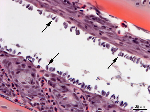
Gills from Lost River suckers with a heavy infestation of Ichthyobodo sp. (arrows). Slide is stained with hematoxylin and eosin.
Gills from Lost River suckers with a heavy infestation of Ichthyobodo sp. (arrows). Slide is stained with hematoxylin and eosin.

Herring (top) and juvenile Chinook salmon (bottom) flushed from the stomach of a resident Chinook salmon in Puget Sound.
Herring (top) and juvenile Chinook salmon (bottom) flushed from the stomach of a resident Chinook salmon in Puget Sound.

Map highlighting sampling locations of 339 Northern Spotted Owls used in Miller, et al, 2018
Map highlighting sampling locations of 339 Northern Spotted Owls used in Miller, et al, 2018

GeoGirls analyze volcanic sediment at the Coldwater Lake outlet.
GeoGirls analyze volcanic sediment at the Coldwater Lake outlet.

GeoGirls take core samples at a pond near the Hummocks Trail to study groundwater transport.
GeoGirls take core samples at a pond near the Hummocks Trail to study groundwater transport.

The GeoGirls examined tephra (ash and pumice) deposits from Mount St. Helens’ eruptive past and learned how to create a stratigraphic column.
The GeoGirls examined tephra (ash and pumice) deposits from Mount St. Helens’ eruptive past and learned how to create a stratigraphic column.