
A team of biologists sits in a circle to weigh and measure captured Red Knots. Photo credit: Zak Pohlenm, USFWS
Images
Images intro.
Filter Total Items: 816

Banding Red Knots at Gray's Harbor
A team of biologists sits in a circle to weigh and measure captured Red Knots. Photo credit: Zak Pohlenm, USFWS

Red Knot after banding at Gray's Harbor
A Red Knot C. c. roselaari captured at Gray's Harbor with a metal band on its right leg. Photo credit: Zak Pohlen, USFWS
A Red Knot C. c. roselaari captured at Gray's Harbor with a metal band on its right leg. Photo credit: Zak Pohlen, USFWS

Red Knot at Gray's Harbor
A Red Knot Calidris canutus roselaari standing on the beach at Gray's Harbor. Photo credit: Zak Pohlenm, USFWS
A Red Knot Calidris canutus roselaari standing on the beach at Gray's Harbor. Photo credit: Zak Pohlenm, USFWS

D-Claw computer simulation of a landslide that begins on Mount Rainier's west flank (Tahoma Glacier Headwall).
D-Claw computer simulation of a landslide that begins on Mount Rainier's west flank (Tahoma Glacier Headwall).Close-up oblique views of Mount Rainier’s west side showing simulated lahar flow depths from a landslide originating in the area of the Tahoma Glacier Headwall (T-260-HM simulation). Imagery appears blurry where lahar material is absent because D-Claw’s adaptive mesh refinement (AMR) employs very coarse resolution in those areas.

USGS Hydrologist Conducts FloaTEM Geophysical Survey on River
USGS Hydrologist Conducts FloaTEM Geophysical Survey on RiverUSGS Hydrologist Eric White monitors a computer displaying real-time data inversions while towing a novel floating transient electromagnetic (TEM) system (i.e., FloaTEM) on the Columbia River near Richland, Washington, adjacent to the Hanford 300 Area.

Photograph of a fish release at the Keller Ferry Marina
Photograph of a fish release at the Keller Ferry MarinaPhotograph of a fish release at the Keller Ferry Marina, Lake Roosevelt, Lincoln County, Washington.
Photograph of a fish release at the Keller Ferry Marina
Photograph of a fish release at the Keller Ferry MarinaPhotograph of a fish release at the Keller Ferry Marina, Lake Roosevelt, Lincoln County, Washington.

Conducting water quality and light at depth measurements Lake Washington
Conducting water quality and light at depth measurements Lake WashingtonPhoto taken from Magnuson boat launch before conducting water quality and light at depth measurements during Landsat-8 overpass windows on Lake Washington for the U.S. Geological Survey.
To learn more about this project and other related research you can visit the WFRC Ecology Section website.

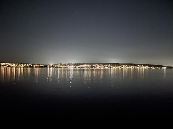
Lighting from the Kirkland waterfront, viewed from the Seattle shoreline
Lighting from the Kirkland waterfront, viewed from the Seattle shorelineLighting from the Kirkland waterfront viewed from the Seattle shoreline.
Photo taken from Magnuson boat launch before conducting a synoptic light survey of Lake Washington for the U.S. Geological Survey.
Lighting from the Kirkland waterfront, viewed from Seattle shoreline
Lighting from the Kirkland waterfront, viewed from Seattle shorelinePhoto taken from Magnuson boat launch before conducting a synoptic light survey of Lake Washington for the U.S. Geological Survey.
Lighting from the Kirkland waterfront, viewed from Seattle shoreline
Lighting from the Kirkland waterfront, viewed from Seattle shorelinePhoto taken from Magnuson boat launch before conducting a synoptic light survey of Lake Washington for the U.S. Geological Survey.

Center Director, Western Fisheries Research Center
Center Director, Western Fisheries Research CenterWestern Fisheries Research Center, Center Director, Michael Schmidt, spending time with his dog, Echo, doing their version of outdoor activities “in the backyard” during a peak in COVID cases.
Center Director, Western Fisheries Research Center
Center Director, Western Fisheries Research CenterWestern Fisheries Research Center, Center Director, Michael Schmidt, spending time with his dog, Echo, doing their version of outdoor activities “in the backyard” during a peak in COVID cases.

High flows move sediment and wood on the Elwha River
High flows move sediment and wood on the Elwha RiverHigh flow on the Elwha River in 2021 at USGS streamgage 12045500. Flooding carried sediment and large wood as well as high volumes of water.
High flows move sediment and wood on the Elwha River
High flows move sediment and wood on the Elwha RiverHigh flow on the Elwha River in 2021 at USGS streamgage 12045500. Flooding carried sediment and large wood as well as high volumes of water.

Side channel of Cowlitz River floods roadway
Hydrologic Technician Andy Cripps measures the flow of floodwaters inundating a roadway. The floodwaters occurred in 2021 from a side channel of the Cowlitz River at USGS streamgage 14231000.
Hydrologic Technician Andy Cripps measures the flow of floodwaters inundating a roadway. The floodwaters occurred in 2021 from a side channel of the Cowlitz River at USGS streamgage 14231000.

Researchers perform gastric lavage on a rainbow trout to sample its stomach contents
Researchers perform gastric lavage on a rainbow trout to sample its stomach contentsResearchers perform gastric lavage on a rainbow trout to sample its stomach contents. This fish was sampled as a part of a food web study on Ross and Diablo Lakes in Washington State to evaluate fish growth and limitations to production.

Barred owl sightings at Oregon Coast Range monitoring sites, 2015
Barred owl sightings at Oregon Coast Range monitoring sites, 2015Locations of barred owl sightings recorded during 2015 owl monitoring activities. Barred owls were lethally removed from the areas highlighted in pink. Supporting data is found at https://doi.org/10.3133/ofr20201089.

Barred owl movement west
Barred owls spread west during the 1900s and today completely overlap the range of the northern spotted owl.
Barred owls spread west during the 1900s and today completely overlap the range of the northern spotted owl.

Barred owl sightings at Oregon Coast Range monitoring sites, 2020
Barred owl sightings at Oregon Coast Range monitoring sites, 2020Locations of barred owl sightings recorded during 2020 owl monitoring activities. Barred owls were lethally removed from the areas highlighted in pink. Supporting data is found at https://doi.org/10.3133/ofr20201089.

Scientist angling on Ross Lake as part of food web study
Scientist angling on Ross Lake as part of food web studyMarshal Hoy, a Biological Science Technician, angling on Ross Lake for Western Fisheries Research Center (WFRC) food web study in October 2021. As a part of this study, fish are sampled for stomach contents, scale samples to assess age and growth, and fin tissue for stable isotopes and genetic analysis.

Lidar rendering Olympia, WA
Lidar point cloud (lpc) rendering for the capitol building in Olympia, Washington
Lidar point cloud (lpc) rendering for the capitol building in Olympia, Washington

USGS boat tied to dock at Ross Lake, Washington in preparation for food web study
USGS boat tied to dock at Ross Lake, Washington in preparation for food web studyUSGS boat tied to dock at Ross Lake during a week-long sampling trip for a food web study. Ross Lake is a large reservoir on the Upper Skagit River in the North Cascade mountains of northern Washington state.

Scientists staging equipment on dock at Ross Lake, Washington preparing for field work
Scientists staging equipment on dock at Ross Lake, Washington preparing for field workResearchers stage sampling equipment at the Ross Lake boat ramp and wait for boat to arrive to transport them to camping area. Food web sampling on large lakes requires a substantial amount of sampling gear. Ross Lake is a large reservoir in the North Cascade mountains of northern Washington state.

Temperature survey of the Quillayute River
Scientists conduct a float survey of the Quillayute River. They measure water temperatures at different depths and locations within the channel along the river's length.
Scientists conduct a float survey of the Quillayute River. They measure water temperatures at different depths and locations within the channel along the river's length.