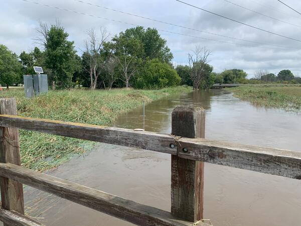
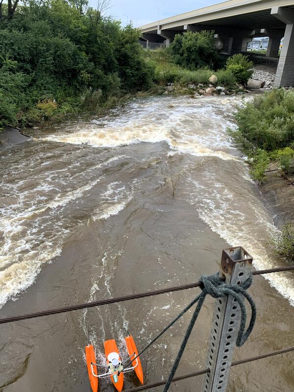
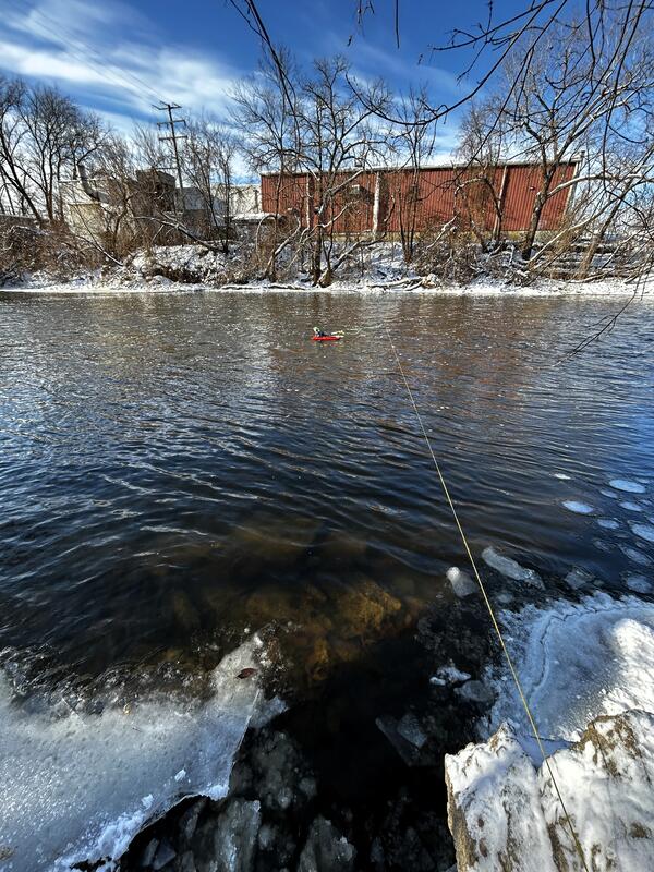
U.S. flag

An official website of the United States government

Images

Images intro.
Filter Total Items: 373
Milwaukee Harbor in foreground with Discovery World building and other tall buildings in background
Milwaukee Harbor and Discovery World on an early autumn day

Milwaukee Harbor in foreground with Discovery World building featured, on an early autumn day.

A close up of a handheld device pointed at a river.
Using a Thermal Infrared Camera to Identify Groundwater Seeps in the Namegagon River

Cold groundwater seep identified using a handheld thermal infrared camera (FLIR E8) on the upper Namekagon River near Cable, Wisconsin. The groundwater discharge area was about 7-8 degrees cooler than the main channel of the Namekagon.

Cold groundwater seep identified using a handheld thermal infrared camera (FLIR E8) on the upper Namekagon River near Cable, Wisconsin. The groundwater discharge area was about 7-8 degrees cooler than the main channel of the Namekagon.

A woman wades a river and writes notes on a pad.
Locating a Groundwater Seep in Namekagon River in Cable, Wisconsin

USGS New England Water Science Center physical scientist Shannon Fisher documenting the location of a groundwater seep under a pine tree on the Namekagon River near Cable, Wisconsin.

USGS New England Water Science Center physical scientist Shannon Fisher documenting the location of a groundwater seep under a pine tree on the Namekagon River near Cable, Wisconsin.

A man in a red vest stands in knee-deep water in a river with a handheld device while another man paddles a canoe.
Identifying Groundwater Seeps in the Namekagon River in Wisconsin

National Park Service Great Lakes Inventory and Monitoring Network (GLKM) biologist Ted Gostomski uses a handheld thermal infrared sensor to identify cold groundwater seeps in the upper Namekagon River near Cable, Wisconsin.  Al Kirschbaum, a remote sensing specialist with the NPS-GLKM, documents Gostomski's findings from the canoe.

National Park Service Great Lakes Inventory and Monitoring Network (GLKM) biologist Ted Gostomski uses a handheld thermal infrared sensor to identify cold groundwater seeps in the upper Namekagon River near Cable, Wisconsin.  Al Kirschbaum, a remote sensing specialist with the NPS-GLKM, documents Gostomski's findings from the canoe.

A USGS technician in a bright green safety jacket takes a photo of a flooded river
Field Crew at Little Menomonee River in Milwaukee, Wisconsin at streamgage 04087070 after flood

A USGS technician in a bright green safety jacket takes a photo of a flooded Little Menomonee River at Milwaukee, Wisconsin, after a flood in August 2025.

Little Menomonee River at Milwaukee, WI - USGS-04087070

https://waterdata.usgs.gov/monitoring-location/USGS-04087070/

A bright orange acoustic Doppler current profiler takes a streamflow measurement in a flooded stream
ADCP measurement at 04087088 Underwood Creek after flooding

An acoustic Doppler current profiler (ADCP) device takes a streamflow measurement at streamgage 04087088 Underwood Creek, near Milwaukee, Wisconsin after a flood event in August 2025.

An acoustic Doppler current profiler (ADCP) device takes a streamflow measurement at streamgage 04087088 Underwood Creek, near Milwaukee, Wisconsin after a flood event in August 2025.

Brown floodwaters swirling in foreground with green trees in background
Flooding at streamgage 04087120 Menomonee River in Wauwatosa, Wisconsin

Floodwaters swirl in the foreground and trees peek up in the background, during flooding of the Menomonee River in Wauwatosa, Wisconsin in August 2025, at streamgage 04087120.

https://waterdata.usgs.gov/monitoring-location/USGS-04087120/

Vibrant map of the Harbor Habitat of Milwaukee, Wisconsin
Harbor Habitat Milwaukee Wisconsin

The center of a vibrant downtown and a commercial shipping hub, the Milwaukee Harbor teems with underwater activity in pockets of habitat full of aquatic life. But look on any map and the harbor is just a blue-black void. The map on this page fills in that gap and invites you to explore the complexity of this remarkable urban ecosystem.

The center of a vibrant downtown and a commercial shipping hub, the Milwaukee Harbor teems with underwater activity in pockets of habitat full of aquatic life. But look on any map and the harbor is just a blue-black void. The map on this page fills in that gap and invites you to explore the complexity of this remarkable urban ecosystem.

View of Hoan Bridge in Milwaukee with seagulls flying in foreground
Hoan Bridge in Milwaukee with seagulls flying in foreground
USGS hydrologic technician installs equipment inside streamgage housing on shore of lake
Installing automated sampler and wireless camera at Barkers Island

USGS Supervisory Hydrologic Technician Ben Torrison installs an automated sampler and wireless camera at Barker’s Island to aid in the remote observation of nearshore algal blooms.

HIVIS | Lake Superior at Barkers Island at Superior

A large plastic sample bottle contains water and brown lignin settling at the bottom
Water sample containing lignin

A large plastic sample bottle contains water and brown lignin settling at the bottom. This is used in benchtop experiments to explore how effective the lignin composites are for removing mercury.

A large plastic sample bottle contains water and brown lignin settling at the bottom. This is used in benchtop experiments to explore how effective the lignin composites are for removing mercury.

Two scientists working in a laboratory
Student working with researchers at Forest Products Laboratory

USGS M3 Research Laboratory summer research student Noor from the University of Wisconsin: Freshwater@UW Summer Research Opportunties Program (Freshwater@UW Summer Research Opportunities Program - Water@UW-Madison) learning how to construct columns for flow through testing with USDA

Map of the Upper Peninsula of Michigan and nearby areas of Northern Wisconsin, with areas of overflights shaded in yellow (Wisconsin) and green (Michigan).
UPMI-WS LLFA.png
UPMI-WS LLFA.png
UPMI-WS LLFA.png

Map of the Upper Peninsula of Michigan and nearby areas of Northern Wisconsin, with areas of overflights shaded in yellow (Wisconsin) and green (Michigan).

Map of the Upper Peninsula of Michigan and nearby areas of Northern Wisconsin, with areas of overflights shaded in yellow (Wisconsin) and green (Michigan).

A geologic map of the state of Wisconsin.
Quaternary Geology of Wisconsin

This is a geologic map showing the Quaternary geology of the state of Wisconsin. It is an update to an older map that was published in 2025 after many years of mapping done by the Wisconsin Geological and Natural History Survey. 

This is a geologic map showing the Quaternary geology of the state of Wisconsin. It is an update to an older map that was published in 2025 after many years of mapping done by the Wisconsin Geological and Natural History Survey. 

A gray metal streamgage housing with an attached solar panel sits on the shore of a snow-covered frozen river.
Streamgage 04065106 Menominee River at Niagara, Wisconsin on a winter day

A gray metal streamgage housing with an attached solar panel sits on the Wisconsin shore of a snow-covered frozen Menominee River. Michigan is in the background across the river.

Streamgage 04065106 Menominee River at Niagara, Wisconsin.

A gray metal streamgage housing with an attached solar panel sits on the Wisconsin shore of a snow-covered frozen Menominee River. Michigan is in the background across the river.

Streamgage 04065106 Menominee River at Niagara, Wisconsin.

Was this page helpful?