
Map displaying National Park Service Units of the Upper Midwest, including Minnesota, Wisconsin and Michigan.
Images
Images intro.
Filter Total Items: 373

National Park Service Units of the Upper Midwest
Map displaying National Park Service Units of the Upper Midwest, including Minnesota, Wisconsin and Michigan.
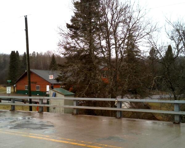
Streamgage 05356000 Chippewa River at Bishops Bridge near Winter, Wisconsin
Streamgage 05356000 Chippewa River at Bishops Bridge near Winter, WisconsinA USGS streamgage housing behind bridge guardrails, with a wet road surface on a rural bridge in the foreground. Leafless trees are in the background under overcast sky.
Streamgage 05356000 Chippewa River at Bishops Bridge near Winter, Wisconsin.

Two swans swim in a wetland in Iowa
Two swans swim in a wetland with agricultural buildings and farmland in the background in Iowa.
Two swans swim in a wetland with agricultural buildings and farmland in the background in Iowa.

Hydrologic Technician makes a wading streamflow measurement during a spring flood event at Siskiwit Falls at Cornucopia, Wisconsin
Hydrologic Technician makes a wading streamflow measurement during a spring flood event at Siskiwit Falls at Cornucopia, WisconsinHydrologic Technician Brandon Nelson makes a wading streamflow measurement during a spring flood event at Siskiwit Falls at Cornucopia, Wisconsin.

Mineral production lifecycle from exploration through reclamation
Mineral production lifecycle from exploration through reclamationArtistic rendition of the mineral lifecycle from a natural state through to exploration, permitting, mining, and reclamation. Designed for the Minerals Lifecycle Integrated Science Team to depict one aspect of their science focus.

Helicopter towing hoop for airborne electromagnetic (AEM) survey 2022
Helicopter towing hoop for airborne electromagnetic (AEM) survey 2022Photo of helicopter with geophysical equipment loop deployed below it via slingload. Technician on ground for scale. In March 2022, a helicopter carried an airborne electromagnetic induction sensor over parts of southeast and southwest Wisconsin as part of a USGS study to map the aquifers in the region.

Airborne electromagnetic (AEM) survey hoop on snowy ground with technician walking by for scale
Airborne electromagnetic (AEM) survey hoop on snowy ground with technician walking by for scaleGeophysical equipment loop for airborne electromagnetic (AEM) survey on ground prior to liftoff. Technician on ground for scale. In March 2022, a helicopter carried an airborne electromagnetic induction sensor over parts of southeast and southwest Wisconsin as part of a USGS study to map the aquifers in the region.

Burke Minsley speaking to group of USGS employees and Cooperators at AEM survey in southwest Wisconsin 2022
Burke Minsley speaking to group of USGS employees and Cooperators at AEM survey in southwest Wisconsin 2022Research geophysicist Burke Minsley discussing aerial electromagnetic (AEM) survey equipment with group of USGS employees and Cooperators at AEM survey in southwest Wisconsin 2022. In March 2022, a helicopter carried an airborne electromagnetic induction sensor over parts of southeast and southwest Wisconsin as part of a USGS study to map the aquifers in t

Airborne electromagnetic (AEM) survey hoop on snowy ground with technician preparing for liftoff
Airborne electromagnetic (AEM) survey hoop on snowy ground with technician preparing for liftoffGeophysical equipment loop for airborne electromagnetic (AEM) survey on ground prior to liftoff. Technician on ground for scale. In March 2022, a helicopter carried an airborne electromagnetic induction sensor over parts of southeast and southwest Wisconsin as part of a USGS study to map the aquifers in the region.

Burke Minsley speaking to group of USGS employees and SkyTEM employees about AEM survey
Burke Minsley speaking to group of USGS employees and SkyTEM employees about AEM surveyResearch geophysicist Burke Minsley discussing aerial electromagnetic (AEM) survey equipment with group of USGS employees and Cooperators at AEM survey in southwest Wisconsin 2022. In March 2022, a helicopter carried an airborne electromagnetic induction sensor over parts of southeast and southwest Wisconsin as part of a USGS study to map the aquifers in t

Group of USGS employees and Cooperators gathered at AEM survey in southwest Wisconsin 2022
Group of USGS employees and Cooperators gathered at AEM survey in southwest Wisconsin 2022Research geophysicist Burke Minsley discussing aerial electromagnetic (AEM) survey equipment with group of USGS employees and Cooperators at AEM survey in southwest Wisconsin 2022. In March 2022, a helicopter carried an airborne electromagnetic induction sensor over parts of southeast and southwest Wisconsin as part of a USGS study to map the aquifers in t
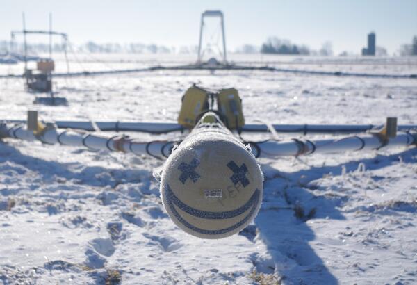
Smiley face on front of AEM survey equipment southern Wisconsin 2022
Smiley face on front of AEM survey equipment southern Wisconsin 2022Smiley face on front of electromagnetic (AEM) survey equipment at AEM survey in southwest Wisconsin 2022. In March 2022, a helicopter carried an airborne electromagnetic induction sensor over parts of southeast and southwest Wisconsin as part of a USGS study to map the aquifers in the region.

USGS employees and Cooperators watching AEM survey helicopter towing hoop liftoff
USGS employees and Cooperators watching AEM survey helicopter towing hoop liftoffUSGS employees and cooperators watching and photographing helicopter lifting off with geophysical equipment loop below attached via slingload. In March 2022, a helicopter carried an airborne electromagnetic induction sensor over parts of southeast and southwest Wisconsin as part of a USGS study to map the aquifers in the region.

Helicopter starting liftoff towing hoop for airborne electromagnetic (AEM) survey 2022
Helicopter starting liftoff towing hoop for airborne electromagnetic (AEM) survey 2022Helicopter lifting off with geophysical equipment loop on ground below attached via slingload. Technician on ground for scale. In March 2022, a helicopter carried an airborne electromagnetic induction sensor over parts of southeast and southwest Wisconsin as part of a USGS study to map the aquifers in the region.

Helicopter liftoff towing hoop for airborne electromagnetic (AEM) survey 2022
Helicopter liftoff towing hoop for airborne electromagnetic (AEM) survey 2022Helicopter lifting off with geophysical equipment loop below attached via slingload. Technician on ground for scale. In March 2022, a helicopter carried an airborne electromagnetic induction sensor over parts of southeast and southwest Wisconsin as part of a USGS study to map the aquifers in the region.

Burke Minsley explaining AEM technology to group of USGS employees and Cooperators at AEM survey in southwest Wisconsin 2022
Burke Minsley explaining AEM technology to group of USGS employees and Cooperators at AEM survey in southwest Wisconsin 2022Research geophysicist Burke Minsley discussing aerial electromagnetic (AEM) survey equipment with group of USGS employees and Cooperators at AEM survey in southwest Wisconsin 2022. In March 2022, a helicopter carried an airborne electromagnetic induction sensor over parts of southeast and southwest Wisconsin as part of a USGS study to map the aquifers in t

Burke Minsley pointing to equipment while speaking to group of USGS employees and Cooperators at AEM survey in southwest Wisconsin 2022
Burke Minsley pointing to equipment while speaking to group of USGS employees and Cooperators at AEM survey in southwest Wisconsin 2022Research geophysicist Burke Minsley discussing aerial electromagnetic (AEM) survey equipment with group of USGS employees and Cooperators at AEM survey in southwest Wisconsin 2022. In March 2022, a helicopter carried an airborne electromagnetic induction sensor over parts of southeast and southwest Wisconsin as part of a USGS study to map the aquifers in t

Sun shining over group of USGS employees and Cooperators at AEM survey in southwest Wisconsin 2022
Sun shining over group of USGS employees and Cooperators at AEM survey in southwest Wisconsin 2022Research geophysicist Burke Minsley discussing aerial electromagnetic (AEM) survey equipment with group of USGS employees and Cooperators at AEM survey in southwest Wisconsin 2022. In March 2022, a helicopter carried an airborne electromagnetic induction sensor over parts of southeast and southwest Wisconsin as part of a USGS study to map the aquifers in t

Helicopter for AEM survey southern Wisconsin 2022
Helicopter used to tow electromagnetic (AEM) survey equipment at AEM survey in southwest Wisconsin 2022. In March 2022, a helicopter carried an airborne electromagnetic induction sensor over parts of southeast and southwest Wisconsin as part of a USGS study to map the aquifers in the region.
Helicopter used to tow electromagnetic (AEM) survey equipment at AEM survey in southwest Wisconsin 2022. In March 2022, a helicopter carried an airborne electromagnetic induction sensor over parts of southeast and southwest Wisconsin as part of a USGS study to map the aquifers in the region.

Sensor on back of geophysical equipment hoop for AEM survey southern Wisconsin 2022
Sensor on back of geophysical equipment hoop for AEM survey southern Wisconsin 2022Geophysical equipment loop with sensor from SKYTEM for electromagnetic (AEM) survey in southwest Wisconsin 2022. In March 2022, a helicopter carried an airborne electromagnetic induction sensor over parts of southeast and southwest Wisconsin as part of a USGS study to map the aquifers in the region.

Where to Go Next
This is a loosely drawn illustration of two hikers on the trail. It was drawn for the final page of a fact sheet and intended for text overlay. The text primarily indicates avenues of further study and next steps of the project.
This is a loosely drawn illustration of two hikers on the trail. It was drawn for the final page of a fact sheet and intended for text overlay. The text primarily indicates avenues of further study and next steps of the project.