On September 30, 2021, Hawaiian Volcano Observatory gas scientists used a FTIR spectrometer on the rim of Halema‘uma‘u crater to measure the composition of gases being emitted during Kīlauea's summit eruption, which began the afternoon of Septembe 29, 2021.
2019 Kīlauea Disaster Supplemental Funding: Eruption Response, Monitoring - Gas
Through the Additional Supplemental Appropriations for Disaster Relief Act of 2019 (H.R. 2157), the USGS received Supplemental funding to support recovery and rebuilding activities in the wake of the 2018 Kīlauea volcano eruption. As part of eruption response bolstering, HVO will harden its capability to detect gases from magma and characterize hazards.

HVO will restore and harden its network of real-time monitoring instruments at the summit and in critical areas along the rift zones to support early detection of magma movement and more accurate and timely characterization of hazards to Island of Hawai‘i communities and Hawai‘i Volcanoes National Park. Instruments lost in the eruption will be replaced, other parts of the network will be modernized, and new instruments will be added. Data from a suite of instruments measuring multiple parameters are required to provide the best warnings and forecasts of eruptive activity. Seismometers, GPS/GNSS, tiltmeters, gas sensors, and gravimeters are needed to assess the state of the volcano. Thermal and visual camera systems will enable HVO to monitor surface activity at the summit and lower East Rift Zone and neighboring Mauna Loa. HVO will restore and improve its capability to detect gases coming from magma rising into the system.
Gas Monitoring

Activity Description/Goal:
Harden HVO capability to detect gases from magma and characterize hazards.
Key Successes/Outcomes:
Ongoing rehabilitation and upgrading of the Flyspec array (10 stations of upward-looking UV spectrometers).
Worked with IT to setup raw data transfer to gas server (vs processed results only); this is a preliminary step in working with Christoph Kern at CVO to upgrade the processing to DOAS (vs FLYSPEC) spectral analysis methodology and possible future conversion of array to portable/reconfigurable vs static/permanent. 4 of 10 stations have new scripts running to transfer raw data; network load is being monitored. Additional stations will have raw data script added pending other station repairs being completed first.
10 of 10 stations have been outfitted with new UV windows. Previous windows had been damaged/etched by years of high SO2 emissions and significant ash deposition during the 2018 events. A new design for the window fittings is in progress and the window fittings will soon be replaced as well.
2 of 10 stations converted to onboard single-board computers had preliminary comms/operability testing
Spectrometers were reassessed for ongoing proper function; 1 of 10 spectrometers was determined to have suffered degradation in light sensitivity over time; it was sent to the manufacturer and has been repaired.
3 of 10 stations have had their initial/aging power supply systems upgraded to modern HVO power setups (“flyaway” power stations), aided by the return of summer gas assistant, Mike Cappos, who was unable to travel during the summer of 2020 due to covid. ~2 additional “flyaway” setups were also built for later use.
1 other station had its power system repaired (not full “flyaway” upgrade”) and batteries replaced

Related

On September 30, 2021, Hawaiian Volcano Observatory gas scientists used a FTIR spectrometer on the rim of Halema‘uma‘u crater to measure the composition of gases being emitted during Kīlauea's summit eruption, which began the afternoon of Septembe 29, 2021.

On September 30, 2021, a Hawaiian Volcano Observatory gas scientist takes notes based on the spectra being displayed by the field laptop, which is connected to a FTIR spectrometer on the rim of Halema‘uma‘u crater.
On the north margin of the south sulfur bank, which was exposed during the Kīlauea summit collapse events in 2018, light-colored deposits are evidence of the ongoing alteration from volcanic gas emissions.
An HVO scientist uses a syringe to capture a sample from an area within Kīlauea caldera that was identified as emitting elevated levels of the volcanic gas carbon dioxide. The sample is transferred to a gas sample bag, which will later be taken to a lab for chemical analyses. USGS photo by K. Mulliken on August 3, 2021.
During the gas survey of Kīlauea caldera, HVO scientists walk transects in a grid-like pattern. As they traverse, the MultiGAS instruments that they are carrying on their backs measure the amount of carbon dioxide (CO2), sulfur dioxide (SO2), water vapor (H2O), and hydrogen sulfide (H2S).
Spatter ramparts from the April 30, 1982, Kīlauea summit eruption remain visible on the floor of Kīlauea caldera. During this brief eruption, which lasted approximately 19 hours, lava erupted from a 1-km-long (0.6 mile) fissure that extended to the northeast of Halema‘uma‘u.
From the northwest corner of the largest down-dropped block within Kīlauea caldera, HVO scientists were able to spot the southern edge of the lava lake that was recently active, from December 2020 to May 2021. The ongoing Kīlauea caldera gas survey is being conducted with permission from Hawai‘i Volcanoes National Park.
HVO scientists continue their survey of Kīlauea caldera floor, including the down-dropped block, for diffuse volcanic gas emissions. This photo shows a large crack, on a portion of the caldera floor that subsided in 2018, that is emitting volcanic gas and steam.
Stacked lava flows are visible in the wall of the down-dropped block, which was exposed during the Kīlauea summit collapse events in 2018. A small exposure of lighter-colored volcanic ash, likely the Keanakāko‘i tephra deposits erupted during Kīlauea's last explosive phase several hundred years ago, is visible beneath tens of meters (yards) of lava flows.

While mapping volcanic gasses in Kīlauea caldera, HVO scientists got a view (looking west) of Halema‘uma‘u and the down-dropped block. The steep crater walls of Halema‘uma‘u are visible in the upper center and right portions of this photo, but the recently active lava lake is out of view below the eastern crater rim.

A USGS scientist calibrates two MultiGas instruments to prepare for mapping volcanic gasses on the floor of Kīlauea caldera. With the MultiGas strapped to metal backpack frames, the scientists traverse across the caldera floor to collect gas data which will be compared to the last survey.

HVO scientists walk transects along the down-dropped portion of Kīlauea caldera floor as part of a gas survey conducted on July 22.

On July 22, HVO scientists surveyed the floor of the down-dropped block within Kīlauea caldera for diffuse volcanic gas emissions. This particular part of the caldera floor subsided during Kīlauea's collapse events in 2018.

An HVO scientist samples the gas around a crack identified as emitting elevated levels of carbon dioxide (a volcanic gas) on the down-dropped block within Kīlauea caldera. The sample will later be analyzed to determine its complete chemical composition. This work was conducted within a closed area of Hawai‘i Volcanoes National Park, with park permission.

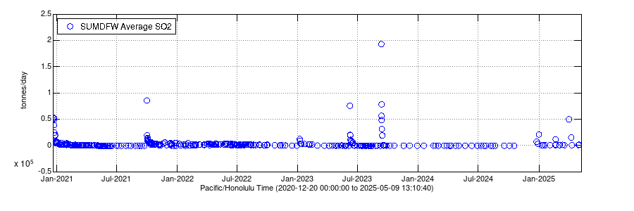
Sulfur dioxide (SO2) emission rates measured using an upward-looking ultraviolet spectrometer. These data are collected by traversing the gas plume in a vehicle or helicopter, downwind of Halema‘uma‘u, generally within and/or southwest of Kīlauea caldera.

View from Mauna Loa Strip Road looking at the Kīlauea summit to document volcanic eruption plumes. Webcam installed December 22, 2020.

On the morning of Dec. 21, Hawaiian Volcano Observatory gas scientists use a FTIR spectrometer on the rim of Halema‘uma‘u crater. The FTIR measures the composition of the gases being emitted during Kīlauea Volcano's ongoing summit eruption by measuring how the plume absorbs infrared energy.

Hawaiian Volcano Observatory field crews captured this photo of the thick gas plume, produced by the Kīlauea summit eruption, obscuring the intensity of the sun.
Tubing inserted into a fumarole at the Sulphur Banks in Hawai‘i Volcanoes National Park allows HVO gas scientists to sample gas. The gas travels through the tube into gas sampling bottles for later analyses. USGS photo by M. Warren.
As part of routine monitoring efforts, HVO gas scientists collected helium samples from fumaroles in the Sulphur Banks, or Ha‘akulamanu, area of Hawai‘i Volcanoes National Park on September 30, 2020. Helium can pass through the glass of typical gas sampling bottles, so copper tubing is necessary for the specialized sample.

Kīlauea
Summit crater lake growth
July 25, 2019 to July 25, 2020
Kīlauea
Summit crater lake growth
July 25, 2019 to July 25, 2020
Related

On September 30, 2021, Hawaiian Volcano Observatory gas scientists used a FTIR spectrometer on the rim of Halema‘uma‘u crater to measure the composition of gases being emitted during Kīlauea's summit eruption, which began the afternoon of Septembe 29, 2021.

On September 30, 2021, a Hawaiian Volcano Observatory gas scientist takes notes based on the spectra being displayed by the field laptop, which is connected to a FTIR spectrometer on the rim of Halema‘uma‘u crater.
On the north margin of the south sulfur bank, which was exposed during the Kīlauea summit collapse events in 2018, light-colored deposits are evidence of the ongoing alteration from volcanic gas emissions.
An HVO scientist uses a syringe to capture a sample from an area within Kīlauea caldera that was identified as emitting elevated levels of the volcanic gas carbon dioxide. The sample is transferred to a gas sample bag, which will later be taken to a lab for chemical analyses. USGS photo by K. Mulliken on August 3, 2021.
During the gas survey of Kīlauea caldera, HVO scientists walk transects in a grid-like pattern. As they traverse, the MultiGAS instruments that they are carrying on their backs measure the amount of carbon dioxide (CO2), sulfur dioxide (SO2), water vapor (H2O), and hydrogen sulfide (H2S).
Spatter ramparts from the April 30, 1982, Kīlauea summit eruption remain visible on the floor of Kīlauea caldera. During this brief eruption, which lasted approximately 19 hours, lava erupted from a 1-km-long (0.6 mile) fissure that extended to the northeast of Halema‘uma‘u.
From the northwest corner of the largest down-dropped block within Kīlauea caldera, HVO scientists were able to spot the southern edge of the lava lake that was recently active, from December 2020 to May 2021. The ongoing Kīlauea caldera gas survey is being conducted with permission from Hawai‘i Volcanoes National Park.
HVO scientists continue their survey of Kīlauea caldera floor, including the down-dropped block, for diffuse volcanic gas emissions. This photo shows a large crack, on a portion of the caldera floor that subsided in 2018, that is emitting volcanic gas and steam.
Stacked lava flows are visible in the wall of the down-dropped block, which was exposed during the Kīlauea summit collapse events in 2018. A small exposure of lighter-colored volcanic ash, likely the Keanakāko‘i tephra deposits erupted during Kīlauea's last explosive phase several hundred years ago, is visible beneath tens of meters (yards) of lava flows.

While mapping volcanic gasses in Kīlauea caldera, HVO scientists got a view (looking west) of Halema‘uma‘u and the down-dropped block. The steep crater walls of Halema‘uma‘u are visible in the upper center and right portions of this photo, but the recently active lava lake is out of view below the eastern crater rim.

A USGS scientist calibrates two MultiGas instruments to prepare for mapping volcanic gasses on the floor of Kīlauea caldera. With the MultiGas strapped to metal backpack frames, the scientists traverse across the caldera floor to collect gas data which will be compared to the last survey.

HVO scientists walk transects along the down-dropped portion of Kīlauea caldera floor as part of a gas survey conducted on July 22.

On July 22, HVO scientists surveyed the floor of the down-dropped block within Kīlauea caldera for diffuse volcanic gas emissions. This particular part of the caldera floor subsided during Kīlauea's collapse events in 2018.

An HVO scientist samples the gas around a crack identified as emitting elevated levels of carbon dioxide (a volcanic gas) on the down-dropped block within Kīlauea caldera. The sample will later be analyzed to determine its complete chemical composition. This work was conducted within a closed area of Hawai‘i Volcanoes National Park, with park permission.

Sulfur dioxide (SO2) emission rates measured using an upward-looking ultraviolet spectrometer. These data are collected by traversing the gas plume in a vehicle or helicopter, downwind of Halema‘uma‘u, generally within and/or southwest of Kīlauea caldera.

View from Mauna Loa Strip Road looking at the Kīlauea summit to document volcanic eruption plumes. Webcam installed December 22, 2020.

On the morning of Dec. 21, Hawaiian Volcano Observatory gas scientists use a FTIR spectrometer on the rim of Halema‘uma‘u crater. The FTIR measures the composition of the gases being emitted during Kīlauea Volcano's ongoing summit eruption by measuring how the plume absorbs infrared energy.

Hawaiian Volcano Observatory field crews captured this photo of the thick gas plume, produced by the Kīlauea summit eruption, obscuring the intensity of the sun.
Tubing inserted into a fumarole at the Sulphur Banks in Hawai‘i Volcanoes National Park allows HVO gas scientists to sample gas. The gas travels through the tube into gas sampling bottles for later analyses. USGS photo by M. Warren.
As part of routine monitoring efforts, HVO gas scientists collected helium samples from fumaroles in the Sulphur Banks, or Ha‘akulamanu, area of Hawai‘i Volcanoes National Park on September 30, 2020. Helium can pass through the glass of typical gas sampling bottles, so copper tubing is necessary for the specialized sample.

Kīlauea
Summit crater lake growth
July 25, 2019 to July 25, 2020
Kīlauea
Summit crater lake growth
July 25, 2019 to July 25, 2020