Kīlauea summit eruption field work – October 7, 2021
Kīlauea summit eruption field work – October 7, 2021An HVO geologist makes observations, collects data, and maintains instruments during the ongoing eruption within Halema'uma'u.

Official websites use .gov
A .gov website belongs to an official government organization in the United States.
Secure .gov websites use HTTPS
A lock () or https:// means you’ve safely connected to the .gov website. Share sensitive information only on official, secure websites.
Through the Additional Supplemental Appropriations for Disaster Relief Act of 2019 (H.R. 2157), the USGS received Supplemental funding to support recovery and rebuilding activities in the wake of the 2018 Kīlauea volcano eruption. As part of eruption response bolstering, HVO will restore and harden its network of monitoring instruments, including cameras.
HVO will restore and harden its network of real-time monitoring instruments at the summit and in critical areas along the rift zones to support early detection of magma movement and more accurate and timely characterization of hazards to Island of Hawai‘i communities and Hawai‘i Volcanoes National Park. Instruments lost in the eruption will be replaced, other parts of the network will be modernized, and new instruments will be added. Data from a suite of instruments measuring multiple parameters are required to provide the best warnings and forecasts of eruptive activity. Seismometers, GPS/GNSS, tiltmeters, gas sensors, and gravimeters are needed to assess the state of the volcano. Thermal and visual camera systems will enable HVO to monitor surface activity at the summit and lower East Rift Zone and neighboring Mauna Loa. HVO will restore and improve its capability to detect gases coming from magma rising into the system.

Activity Description/Goal: Harden HVO visual and thermal camera monitoring capacity to enable more accurate detection and rapid characterization of hazards.
Key Successes/Outcomes:
2019-2020 Kīlauea summit water lake:
2020-21 Kīlauea summit eruption response:


2021 Kīlauea summit intrusion response:

An HVO geologist makes observations, collects data, and maintains instruments during the ongoing eruption within Halema'uma'u.
An HVO geologist makes observations, collects data, and maintains instruments during the ongoing eruption within Halema'uma'u.

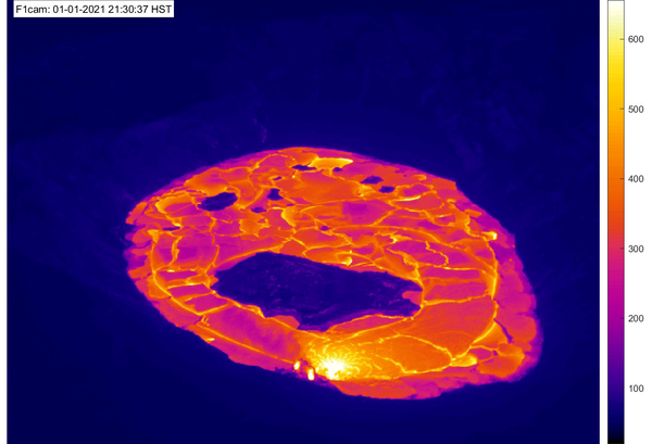
View looking down at the September-October 2021 lava lake eruption of Halemaʻumaʻu from the F1 thermal camera located on the western rim of the crater at Kīlauea’s summit. Molten material appears as warmer colors of yellow, orange, and pink, whereas cooler material is represented by dark blue and purple colors.
View looking down at the September-October 2021 lava lake eruption of Halemaʻumaʻu from the F1 thermal camera located on the western rim of the crater at Kīlauea’s summit. Molten material appears as warmer colors of yellow, orange, and pink, whereas cooler material is represented by dark blue and purple colors.

This thermal image was taken during the morning overflight on September 30, 2021, and looks west across Halema‘uma‘u crater, at the summit of Kīlauea. Several fountains are emerging through the active lake surface, in addition to fountaining on the west margin of the lake.
This thermal image was taken during the morning overflight on September 30, 2021, and looks west across Halema‘uma‘u crater, at the summit of Kīlauea. Several fountains are emerging through the active lake surface, in addition to fountaining on the west margin of the lake.
Last 24 Hours - Live view of Kīlauea caldera down-dropped block and Halemaʻumaʻu crater from the east rim of the caldera [B1cam].
Last 24 Hours - Live view of Kīlauea caldera down-dropped block and Halemaʻumaʻu crater from the east rim of the caldera [B1cam].
April 20 was the four-month anniversary of Kīlauea's ongoing summit eruption in Halema‘uma‘u. This animated GIF features approximately one thermal image for each day of the eruption and demonstrates eruptive activity over the past four months. At 9:30 p.m.
April 20 was the four-month anniversary of Kīlauea's ongoing summit eruption in Halema‘uma‘u. This animated GIF features approximately one thermal image for each day of the eruption and demonstrates eruptive activity over the past four months. At 9:30 p.m.
ANIMATED GIF: This animated image file (GIF) includes a series of thermal maps—ranging from daily to several weeks apart—made from helicopter overflight thermal imagery of Halema‘uma‘u crater, Kīlauea summit. The set of thermal maps are in a continuous loop showing the lava lake changes throughout the eruption.
ANIMATED GIF: This animated image file (GIF) includes a series of thermal maps—ranging from daily to several weeks apart—made from helicopter overflight thermal imagery of Halema‘uma‘u crater, Kīlauea summit. The set of thermal maps are in a continuous loop showing the lava lake changes throughout the eruption.

This thermal image, looking northwest, shows the distribution of activity on the lava lake at Kīlauea's summit. The lake is slightly perched and surrounded along its perimeter by a lower ledge of cooler lava. The western fissure, in the wall of Halema‘uma‘u crater, is visible in the upper left portion of the image, just above the lake.
This thermal image, looking northwest, shows the distribution of activity on the lava lake at Kīlauea's summit. The lake is slightly perched and surrounded along its perimeter by a lower ledge of cooler lava. The western fissure, in the wall of Halema‘uma‘u crater, is visible in the upper left portion of the image, just above the lake.
")
Kīlauea Volcano, U.S. Geological Survey Hawaiian Volcano Observatory timelapse of thermal imagery showing Halema‘uma‘u west vents and lava entering the lava lake. This timelapse was taken over one hour, between approximately 10 and 11 p.m on December 29, 2020.
Kīlauea Volcano, U.S. Geological Survey Hawaiian Volcano Observatory timelapse of thermal imagery showing Halema‘uma‘u west vents and lava entering the lava lake. This timelapse was taken over one hour, between approximately 10 and 11 p.m on December 29, 2020.

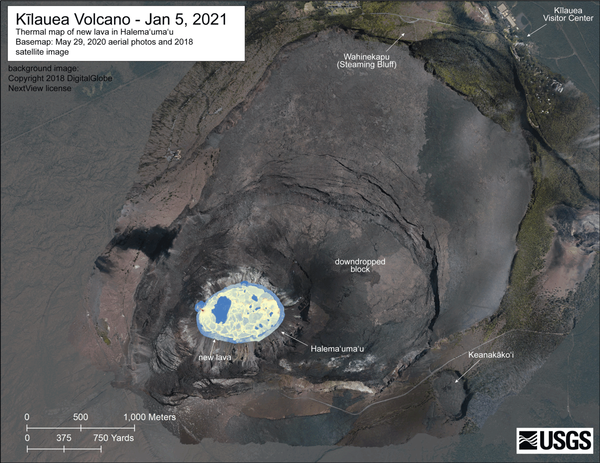
A helicopter overflight yesterday (Dec. 28, 2020) at approximately 10:30 AM HST allowed for aerial visual and thermal imagery to be collected of the new eruption within Halema'uma'u crater at the summit of Kīlauea Volcano. This preliminary thermal map shows that the lake area has not changed significantly since the thermal map that was made on December 26.
A helicopter overflight yesterday (Dec. 28, 2020) at approximately 10:30 AM HST allowed for aerial visual and thermal imagery to be collected of the new eruption within Halema'uma'u crater at the summit of Kīlauea Volcano. This preliminary thermal map shows that the lake area has not changed significantly since the thermal map that was made on December 26.

This comparison shows thermal images taken yesterday and today during USGS Hawaiian Volcano Observatory helicopter overflights. The main difference in this 24 hour period is the significant rise and infilling of the lava lake within Halema‘uma‘u crater at Kīlauea summit. This morning, the lake depth was measured at approximately 130 yards. USGS images by M.
This comparison shows thermal images taken yesterday and today during USGS Hawaiian Volcano Observatory helicopter overflights. The main difference in this 24 hour period is the significant rise and infilling of the lava lake within Halema‘uma‘u crater at Kīlauea summit. This morning, the lake depth was measured at approximately 130 yards. USGS images by M.

A comparison of two thermal images from the F1cam thermal webcam located on the rim of Halema‘uma‘u crater, at the summit of Kīlauea volcano. These two images were taken 48 hours apart. The left image from December 20 at 8:22 a.m.
A comparison of two thermal images from the F1cam thermal webcam located on the rim of Halema‘uma‘u crater, at the summit of Kīlauea volcano. These two images were taken 48 hours apart. The left image from December 20 at 8:22 a.m.
Last 24 Hours - Live thermal image of Halemaʻumaʻu from the west rim of the summit caldera, looking east [F1cam]. Thermal webcams record in Centigrade, conversions to Fahrenheit are provided here for your convenience: 20°C=68°F, 40°C=104°F, 60°C=140°F, 80°C=176°F.
Last 24 Hours - Live thermal image of Halemaʻumaʻu from the west rim of the summit caldera, looking east [F1cam]. Thermal webcams record in Centigrade, conversions to Fahrenheit are provided here for your convenience: 20°C=68°F, 40°C=104°F, 60°C=140°F, 80°C=176°F.

During today's overflight of Kīlauea summit, both thermal and visual cameras were used to characterize activity. Comparing thermal (left) to visual (right) images of nearly the same view, you can see that the growing crater lake at Kīlauea's summit remains hot.
During today's overflight of Kīlauea summit, both thermal and visual cameras were used to characterize activity. Comparing thermal (left) to visual (right) images of nearly the same view, you can see that the growing crater lake at Kīlauea's summit remains hot.

An HVO scientist tests a colorimeter instrument on the water lake within Halema‘uma‘u, at Kīlauea's summit. Colorimetry is the measurement of the wavelength and intensity of light. USGS photo by M. Patrick.
An HVO scientist tests a colorimeter instrument on the water lake within Halema‘uma‘u, at Kīlauea's summit. Colorimetry is the measurement of the wavelength and intensity of light. USGS photo by M. Patrick.

The December 18 overflight provided updated thermal images of Kīlauea summit, covering the caldera floor and showing the warm surface of the water pond in Halema‘uma‘u crater. A band of warm temperatures persists along the new cliff formed during the 2018 subsidence.
The December 18 overflight provided updated thermal images of Kīlauea summit, covering the caldera floor and showing the warm surface of the water pond in Halema‘uma‘u crater. A band of warm temperatures persists along the new cliff formed during the 2018 subsidence.

The December 18 overflight provided updated thermal images of Kīlauea summit, covering the caldera floor and showing the warm surface of the water pond in Halema‘uma‘u crater. A band of warm temperatures persists along the new cliff formed during the 2018 subsidence.
The December 18 overflight provided updated thermal images of Kīlauea summit, covering the caldera floor and showing the warm surface of the water pond in Halema‘uma‘u crater. A band of warm temperatures persists along the new cliff formed during the 2018 subsidence.
An HVO geologist makes observations, collects data, and maintains instruments during the ongoing eruption within Halema'uma'u.
An HVO geologist makes observations, collects data, and maintains instruments during the ongoing eruption within Halema'uma'u.
View looking down at the September-October 2021 lava lake eruption of Halemaʻumaʻu from the F1 thermal camera located on the western rim of the crater at Kīlauea’s summit. Molten material appears as warmer colors of yellow, orange, and pink, whereas cooler material is represented by dark blue and purple colors.
View looking down at the September-October 2021 lava lake eruption of Halemaʻumaʻu from the F1 thermal camera located on the western rim of the crater at Kīlauea’s summit. Molten material appears as warmer colors of yellow, orange, and pink, whereas cooler material is represented by dark blue and purple colors.
This thermal image was taken during the morning overflight on September 30, 2021, and looks west across Halema‘uma‘u crater, at the summit of Kīlauea. Several fountains are emerging through the active lake surface, in addition to fountaining on the west margin of the lake.
This thermal image was taken during the morning overflight on September 30, 2021, and looks west across Halema‘uma‘u crater, at the summit of Kīlauea. Several fountains are emerging through the active lake surface, in addition to fountaining on the west margin of the lake.
Last 24 Hours - Live view of Kīlauea caldera down-dropped block and Halemaʻumaʻu crater from the east rim of the caldera [B1cam].
Last 24 Hours - Live view of Kīlauea caldera down-dropped block and Halemaʻumaʻu crater from the east rim of the caldera [B1cam].
April 20 was the four-month anniversary of Kīlauea's ongoing summit eruption in Halema‘uma‘u. This animated GIF features approximately one thermal image for each day of the eruption and demonstrates eruptive activity over the past four months. At 9:30 p.m.
April 20 was the four-month anniversary of Kīlauea's ongoing summit eruption in Halema‘uma‘u. This animated GIF features approximately one thermal image for each day of the eruption and demonstrates eruptive activity over the past four months. At 9:30 p.m.
ANIMATED GIF: This animated image file (GIF) includes a series of thermal maps—ranging from daily to several weeks apart—made from helicopter overflight thermal imagery of Halema‘uma‘u crater, Kīlauea summit. The set of thermal maps are in a continuous loop showing the lava lake changes throughout the eruption.
ANIMATED GIF: This animated image file (GIF) includes a series of thermal maps—ranging from daily to several weeks apart—made from helicopter overflight thermal imagery of Halema‘uma‘u crater, Kīlauea summit. The set of thermal maps are in a continuous loop showing the lava lake changes throughout the eruption.
This thermal image, looking northwest, shows the distribution of activity on the lava lake at Kīlauea's summit. The lake is slightly perched and surrounded along its perimeter by a lower ledge of cooler lava. The western fissure, in the wall of Halema‘uma‘u crater, is visible in the upper left portion of the image, just above the lake.
This thermal image, looking northwest, shows the distribution of activity on the lava lake at Kīlauea's summit. The lake is slightly perched and surrounded along its perimeter by a lower ledge of cooler lava. The western fissure, in the wall of Halema‘uma‘u crater, is visible in the upper left portion of the image, just above the lake.
Kīlauea Volcano, U.S. Geological Survey Hawaiian Volcano Observatory timelapse of thermal imagery showing Halema‘uma‘u west vents and lava entering the lava lake. This timelapse was taken over one hour, between approximately 10 and 11 p.m on December 29, 2020.
Kīlauea Volcano, U.S. Geological Survey Hawaiian Volcano Observatory timelapse of thermal imagery showing Halema‘uma‘u west vents and lava entering the lava lake. This timelapse was taken over one hour, between approximately 10 and 11 p.m on December 29, 2020.
A helicopter overflight yesterday (Dec. 28, 2020) at approximately 10:30 AM HST allowed for aerial visual and thermal imagery to be collected of the new eruption within Halema'uma'u crater at the summit of Kīlauea Volcano. This preliminary thermal map shows that the lake area has not changed significantly since the thermal map that was made on December 26.
A helicopter overflight yesterday (Dec. 28, 2020) at approximately 10:30 AM HST allowed for aerial visual and thermal imagery to be collected of the new eruption within Halema'uma'u crater at the summit of Kīlauea Volcano. This preliminary thermal map shows that the lake area has not changed significantly since the thermal map that was made on December 26.
This comparison shows thermal images taken yesterday and today during USGS Hawaiian Volcano Observatory helicopter overflights. The main difference in this 24 hour period is the significant rise and infilling of the lava lake within Halema‘uma‘u crater at Kīlauea summit. This morning, the lake depth was measured at approximately 130 yards. USGS images by M.
This comparison shows thermal images taken yesterday and today during USGS Hawaiian Volcano Observatory helicopter overflights. The main difference in this 24 hour period is the significant rise and infilling of the lava lake within Halema‘uma‘u crater at Kīlauea summit. This morning, the lake depth was measured at approximately 130 yards. USGS images by M.
A comparison of two thermal images from the F1cam thermal webcam located on the rim of Halema‘uma‘u crater, at the summit of Kīlauea volcano. These two images were taken 48 hours apart. The left image from December 20 at 8:22 a.m.
A comparison of two thermal images from the F1cam thermal webcam located on the rim of Halema‘uma‘u crater, at the summit of Kīlauea volcano. These two images were taken 48 hours apart. The left image from December 20 at 8:22 a.m.
Last 24 Hours - Live thermal image of Halemaʻumaʻu from the west rim of the summit caldera, looking east [F1cam]. Thermal webcams record in Centigrade, conversions to Fahrenheit are provided here for your convenience: 20°C=68°F, 40°C=104°F, 60°C=140°F, 80°C=176°F.
Last 24 Hours - Live thermal image of Halemaʻumaʻu from the west rim of the summit caldera, looking east [F1cam]. Thermal webcams record in Centigrade, conversions to Fahrenheit are provided here for your convenience: 20°C=68°F, 40°C=104°F, 60°C=140°F, 80°C=176°F.
During today's overflight of Kīlauea summit, both thermal and visual cameras were used to characterize activity. Comparing thermal (left) to visual (right) images of nearly the same view, you can see that the growing crater lake at Kīlauea's summit remains hot.
During today's overflight of Kīlauea summit, both thermal and visual cameras were used to characterize activity. Comparing thermal (left) to visual (right) images of nearly the same view, you can see that the growing crater lake at Kīlauea's summit remains hot.
An HVO scientist tests a colorimeter instrument on the water lake within Halema‘uma‘u, at Kīlauea's summit. Colorimetry is the measurement of the wavelength and intensity of light. USGS photo by M. Patrick.
An HVO scientist tests a colorimeter instrument on the water lake within Halema‘uma‘u, at Kīlauea's summit. Colorimetry is the measurement of the wavelength and intensity of light. USGS photo by M. Patrick.
The December 18 overflight provided updated thermal images of Kīlauea summit, covering the caldera floor and showing the warm surface of the water pond in Halema‘uma‘u crater. A band of warm temperatures persists along the new cliff formed during the 2018 subsidence.
The December 18 overflight provided updated thermal images of Kīlauea summit, covering the caldera floor and showing the warm surface of the water pond in Halema‘uma‘u crater. A band of warm temperatures persists along the new cliff formed during the 2018 subsidence.
The December 18 overflight provided updated thermal images of Kīlauea summit, covering the caldera floor and showing the warm surface of the water pond in Halema‘uma‘u crater. A band of warm temperatures persists along the new cliff formed during the 2018 subsidence.
The December 18 overflight provided updated thermal images of Kīlauea summit, covering the caldera floor and showing the warm surface of the water pond in Halema‘uma‘u crater. A band of warm temperatures persists along the new cliff formed during the 2018 subsidence.