
2023 Supplemental Appropriation Activities
Title VII of Division N in the Consolidated Appropriations Act, 2023 (Public Law 117–328), was enacted on December 29, 2022. The USGS received $41.04 million in supplemental funding to support direct recovery and rebuilding decisions in the wake of declared disasters related to hurricanes and typhoons in 2022.
Specific activities funded in 2023
Media
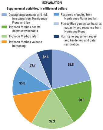
Sources/Usage: Public Domain. View Media Details
USGS disaster emergency supplemental activities funded under the Consolidated Appropriations Act include:
- Hurricane Equipment Repair and Hardening and Data Restoration
- Coastal Assessments and Risk Forecasts from Hurricanes Fiona and Ian
- Puerto Rico Geological Hazards Capacity and Response
- Resource Mapping in Florida and Puerto Rico
- Typhoon Merbok Volcano Hardening
- Typhoon Merbok Coastal Community Impacts
- Lidar for Typhoon Merbok
Related
Digital Shoreline Analysis System (DSAS)
Software for calculating positional boundary change over time The Digital Shoreline Analysis System (DSAS) version 6 is a standalone application that calculates shoreline or boundary change over time. The GIS of a user’s choice is used to prepare the data for DSAS. Like previous versions, DSAS v.6 enables a user to calculate rate-of-change statistics from multiple historical shoreline positions...
Alaska Flood Staffs
The U.S. Geological Survey (USGS) uses observations of flooding in communities to monitor hazard conditions and support research by the USGS and its partners into a variety of hazard processes in Alaska. Local observations of flooding at flood staffs are used to document flood elevations, improve flood models, and support floodplain management decisions.
Coastal Single-Beam Bathymetry Data: Midnight Pass and Milton Pass, Florida, June 2025 Coastal Single-Beam Bathymetry Data: Midnight Pass and Milton Pass, Florida, June 2025
In June 2025, the U.S. Geological Survey St. Petersburg Coastal and Marine Science Center (USGS SPCMSC) participated in a multidisciplinary geoscientific field data collection within Midnight Pass and Milton Pass located along Florida’s west-central coastline, which opened as a result of hurricanes Helene and Milton in 2024. Researchers with the Nearshore Extreme Events Reconnaissance...
Thematic response frequency of user feedback on coastal science products Thematic response frequency of user feedback on coastal science products
Decision support tools play a critical role in assisting coastal decision-makers in managing coastal systems; yet there are challenges to developing tools that align with the functional needs of end-users. By combining usability testing and contextual inquiry methods, we put forth a hybrid approach for collecting user feedback within the context of federal government research. This...
Storm-Induced Overwash Extent Storm-Induced Overwash Extent
The Coastal Change Hazards Technical Capabilities and Applications project at the U.S. Geological Survey (USGS) exists to understand and predict storm impacts to our nation’s coastlines. This data release defines the alongshore extent of overwash deposits, determined from aerial photograph analysis, attributed to coastal processes during storm events. Note: This data release was...
Lidar-derived Beach Morphology (Dune Crest, Dune Toe, and Shoreline) for U.S. Sandy Coastlines Lidar-derived Beach Morphology (Dune Crest, Dune Toe, and Shoreline) for U.S. Sandy Coastlines
The U.S. Geological Survey (USGS)Coastal Change Hazards Technical Capabilities and Applications (TCA) project aims to identify areas of the nation’s coastline that are most vulnerable to extreme storms and long-term shoreline change. These assessments require coastal elevation data across diverse geographic regions and covering a time span of many years. The datasets published here...
Storm-Induced Coastal Change Forecasts: Archive of Individual Storm Events Storm-Induced Coastal Change Forecasts: Archive of Individual Storm Events
These data sets contain information on the probabilities of storm-induced erosion (collision, inundation and overwash) on sandy beaches along the U.S. Gulf and Atlantic coasts during real-time peak forecast conditions. The analysis is based on a storm-impact scaling model that uses observations of beach morphology combined with sophisticated hydrodynamic models to predict how the coast...
Consolidated Appropriations Act, 2023—USGS disaster emergency recovery activities Consolidated Appropriations Act, 2023—USGS disaster emergency recovery activities
Title VII of Division N in the Consolidated Appropriations Act, 2023 (Public Law 117–328), was enacted on December 29, 2022. The U.S. Geological Survey received $41.04 million in disaster emergency supplemental funding for repairing and replacing facilities and equipment, collecting high-resolution elevation data in affected areas, and completing scientific assessments to support direct...
Authors
Jo Ellen Hinck, Joseph Stachyra
Coastal Science Navigator companion guide—Discover the U.S. Geological Survey coastal science products you need Coastal Science Navigator companion guide—Discover the U.S. Geological Survey coastal science products you need
The Coastal Science Navigator is an online gateway to a wide variety of U.S. Geological Survey (USGS) coastal change hazards-related information, data, and tools relevant to stakeholders’ scientific and decision-making needs. The products within the Coastal Science Navigator provide data related to past, present, and future threats to our coastlines. The filter search allows users to see...
Authors
Mira Anderberg, Sara Ernst
Current and projected flood exposure for Alaska coastal communities Current and projected flood exposure for Alaska coastal communities
Globally, coastal communities experience flood hazards that are projected to worsen from climate change and sea level rise. The 100-year floodplain or record flood are commonly used to identify risk areas for planning purposes. Remote communities often lack measured flood elevations and require innovative approaches to estimate flood elevations. This study employs observation-based...
Authors
Richard Michael Buzard, Christopher V. Maio, Li H. Erikson, Jacquelyn R. Overbeck, Nicole E. M. Kinsman, Benjamin M. Jones
Coastal Science Navigator Coastal Science Navigator
An online gateway for users such as state and local planners, resources managers, consultants, and researchers to more easily gain access to USGS coastal science data, products, tools, and information.
Digital Shoreline Analysis System version 6.1 Digital Shoreline Analysis System version 6.1
The Digital Shoreline Analysis System (version 6) is a stand-alone desktop application that compliments a Geographic Information System (GIS). The DSAS software requires users to input a reference baseline and compilation of shoreline positions to generate measurement transects and shoreline intersections used to calculate rate-of-change statistics. DSAS provides an automated method for
Related
Digital Shoreline Analysis System (DSAS)
Software for calculating positional boundary change over time The Digital Shoreline Analysis System (DSAS) version 6 is a standalone application that calculates shoreline or boundary change over time. The GIS of a user’s choice is used to prepare the data for DSAS. Like previous versions, DSAS v.6 enables a user to calculate rate-of-change statistics from multiple historical shoreline positions...
Alaska Flood Staffs
The U.S. Geological Survey (USGS) uses observations of flooding in communities to monitor hazard conditions and support research by the USGS and its partners into a variety of hazard processes in Alaska. Local observations of flooding at flood staffs are used to document flood elevations, improve flood models, and support floodplain management decisions.
Coastal Single-Beam Bathymetry Data: Midnight Pass and Milton Pass, Florida, June 2025 Coastal Single-Beam Bathymetry Data: Midnight Pass and Milton Pass, Florida, June 2025
In June 2025, the U.S. Geological Survey St. Petersburg Coastal and Marine Science Center (USGS SPCMSC) participated in a multidisciplinary geoscientific field data collection within Midnight Pass and Milton Pass located along Florida’s west-central coastline, which opened as a result of hurricanes Helene and Milton in 2024. Researchers with the Nearshore Extreme Events Reconnaissance...
Thematic response frequency of user feedback on coastal science products Thematic response frequency of user feedback on coastal science products
Decision support tools play a critical role in assisting coastal decision-makers in managing coastal systems; yet there are challenges to developing tools that align with the functional needs of end-users. By combining usability testing and contextual inquiry methods, we put forth a hybrid approach for collecting user feedback within the context of federal government research. This...
Storm-Induced Overwash Extent Storm-Induced Overwash Extent
The Coastal Change Hazards Technical Capabilities and Applications project at the U.S. Geological Survey (USGS) exists to understand and predict storm impacts to our nation’s coastlines. This data release defines the alongshore extent of overwash deposits, determined from aerial photograph analysis, attributed to coastal processes during storm events. Note: This data release was...
Lidar-derived Beach Morphology (Dune Crest, Dune Toe, and Shoreline) for U.S. Sandy Coastlines Lidar-derived Beach Morphology (Dune Crest, Dune Toe, and Shoreline) for U.S. Sandy Coastlines
The U.S. Geological Survey (USGS)Coastal Change Hazards Technical Capabilities and Applications (TCA) project aims to identify areas of the nation’s coastline that are most vulnerable to extreme storms and long-term shoreline change. These assessments require coastal elevation data across diverse geographic regions and covering a time span of many years. The datasets published here...
Storm-Induced Coastal Change Forecasts: Archive of Individual Storm Events Storm-Induced Coastal Change Forecasts: Archive of Individual Storm Events
These data sets contain information on the probabilities of storm-induced erosion (collision, inundation and overwash) on sandy beaches along the U.S. Gulf and Atlantic coasts during real-time peak forecast conditions. The analysis is based on a storm-impact scaling model that uses observations of beach morphology combined with sophisticated hydrodynamic models to predict how the coast...
Consolidated Appropriations Act, 2023—USGS disaster emergency recovery activities Consolidated Appropriations Act, 2023—USGS disaster emergency recovery activities
Title VII of Division N in the Consolidated Appropriations Act, 2023 (Public Law 117–328), was enacted on December 29, 2022. The U.S. Geological Survey received $41.04 million in disaster emergency supplemental funding for repairing and replacing facilities and equipment, collecting high-resolution elevation data in affected areas, and completing scientific assessments to support direct...
Authors
Jo Ellen Hinck, Joseph Stachyra
Coastal Science Navigator companion guide—Discover the U.S. Geological Survey coastal science products you need Coastal Science Navigator companion guide—Discover the U.S. Geological Survey coastal science products you need
The Coastal Science Navigator is an online gateway to a wide variety of U.S. Geological Survey (USGS) coastal change hazards-related information, data, and tools relevant to stakeholders’ scientific and decision-making needs. The products within the Coastal Science Navigator provide data related to past, present, and future threats to our coastlines. The filter search allows users to see...
Authors
Mira Anderberg, Sara Ernst
Current and projected flood exposure for Alaska coastal communities Current and projected flood exposure for Alaska coastal communities
Globally, coastal communities experience flood hazards that are projected to worsen from climate change and sea level rise. The 100-year floodplain or record flood are commonly used to identify risk areas for planning purposes. Remote communities often lack measured flood elevations and require innovative approaches to estimate flood elevations. This study employs observation-based...
Authors
Richard Michael Buzard, Christopher V. Maio, Li H. Erikson, Jacquelyn R. Overbeck, Nicole E. M. Kinsman, Benjamin M. Jones
Coastal Science Navigator Coastal Science Navigator
An online gateway for users such as state and local planners, resources managers, consultants, and researchers to more easily gain access to USGS coastal science data, products, tools, and information.
Digital Shoreline Analysis System version 6.1 Digital Shoreline Analysis System version 6.1
The Digital Shoreline Analysis System (version 6) is a stand-alone desktop application that compliments a Geographic Information System (GIS). The DSAS software requires users to input a reference baseline and compilation of shoreline positions to generate measurement transects and shoreline intersections used to calculate rate-of-change statistics. DSAS provides an automated method for