
...to informing restoration efforts in the Florida Everglades
...to tracking storm-related flood conditions through the South Atlantic...
...to investigating coral health in the Florida Keys & Caribbean...
...to assessing environmental contaminants on aquatic life in the Mississippi River Basin...
...USGS science spans the South Atlantic, Gulf States and Caribbean
The Southeast Region includes 13 states and two U.S. territories, Puerto Rico and the U.S. Virgin Islands
The Southeast Region includes 13 states and two U.S. territories, Puerto Rico and the U.S. Virgin Islands
Southeast Region
We conduct impartial, multi- and interdisciplinary research and monitoring to address a broad range of natural-resource issues that affect the quality of life of citizens and landscapes in the Southeastern United States and the Caribbean region.
News
USGS: Lithium in Carolinas Could Replace Imports for a Century or More
USGS: Lithium in Carolinas Could Replace Imports for a Century or More
Lithium in Eastern States Could Replace Imports for a Century or More
Lithium in Eastern States Could Replace Imports for a Century or More
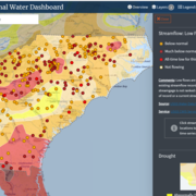
New Nationwide Tool Helps Answer: Do We Have Enough Water?
New Nationwide Tool Helps Answer: Do We Have Enough Water?
Publications
Streamflow characterization and effects of Interstate 26 highway construction on water-quality and channel morphology conditions of the French Broad River in Buncombe and Henderson Counties, North Carolina, 2019–22 Streamflow characterization and effects of Interstate 26 highway construction on water-quality and channel morphology conditions of the French Broad River in Buncombe and Henderson Counties, North Carolina, 2019–22
The North Carolina Department of Transportation began a series of highway construction projects to upgrade Interstate 26 (I–26) in Buncombe and Henderson Counties, North Carolina, starting in early 2020. The North Carolina Department of Transportation and the U.S. Geological Survey partnered in 2019 to monitor and assess water-quality and geomorphic conditions throughout the French Broad...
A review of extraction techniques for per- and polyfluoroalkyl substances in graminaceous plants A review of extraction techniques for per- and polyfluoroalkyl substances in graminaceous plants
Per- and polyfluoroalkyl substances (PFAS) are a wide-ranging class of manufactured chemicals that are environmentally persistent. Due to their ubiquity and resistance to degradation, PFAS readily bioaccumulate in a variety of environmental matrices and elicit a range of toxicological impacts. Despite an increase in research into these compounds, there is a clear gap in consensus on...
An automatable method for developing preliminary stream crossing designs using lidar and hydraulic modeling in Massachusetts An automatable method for developing preliminary stream crossing designs using lidar and hydraulic modeling in Massachusetts
Upgrading aging and undersized stream crossings (places where culverts and bridges intersect a stream) with replacements designed for aquatic organism passage can improve infrastructure resiliency, geomorphic stability, and maintenance costs. The goal of this work is to develop preliminary culvert designs that convey hydraulic design floods and meet the Massachusetts Stream Crossings...
Science

Mobile River Basin Study
The Mobile River Basin in Alabama, Georgia, Mississippi, and Tennessee is one of the 59 study units that are part of the U.S. Geological Survey's National Water-Quality Assessment (NAWQA) Program. The long-term goals of this program are to describe the status and trends in the quality of a large, representative part of the Nation's surface- and ground-water resources, and to provide a sound...

River WebCams of the South Atlantic Water Science Center (Georgia, North and South Carolina)
We have installed webcams at a number of locations in Georgia, North Carolina, and South Carolina to allow you to view, in real time, the current river-stage conditions. Some cameras allow users to temporarily control the tilt, pan, and zoom. During periods of flooding, the South Atlantic Water Science Center might take control of the camera. Click on the Study Area Map icons for more information...
South Atlantic Water Science Center Drought Monitoring
When rainfall is less than normal for several weeks, months, or years, the flow of streams and rivers declines, water levels in lakes and reservoirs fall, and the depth to water in wells increases. If dry weather persists and water-supply problems develop, the dry period can become a drought.