
USGS hydrologist Mark Reid looks at one of the many grabens (extensional basins) that formed as the Oso landslide swept across the North Fork Stillaguamish River valley.
Images
Explore images.
Filter Total Items: 698

Scientist stands on the bank of a still river
USGS hydrologist Mark Reid looks at one of the many grabens (extensional basins) that formed as the Oso landslide swept across the North Fork Stillaguamish River valley.

USGS Documents 2015 Drought
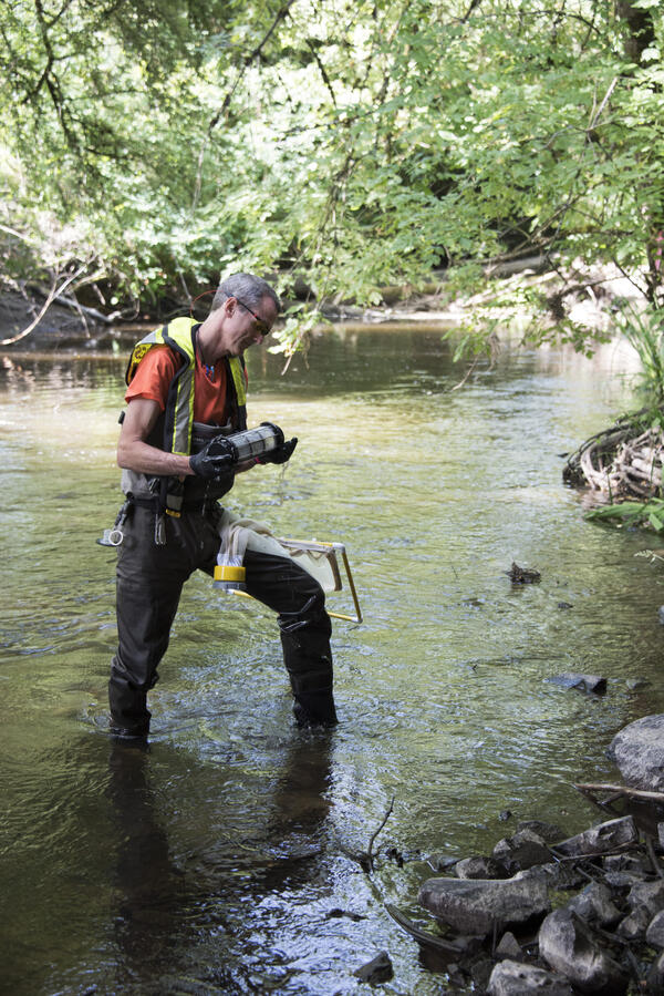
A hydrologic technician from the USGS Idaho Water Science Center measures streamflow in Fall Creek near Anderson Ranch Dam in southwestern Idaho. The USGS is collecting data at hundreds of sites on rivers and streams in six western states to document the 2015 drought.
A hydrologic technician from the USGS Idaho Water Science Center measures streamflow in Fall Creek near Anderson Ranch Dam in southwestern Idaho. The USGS is collecting data at hundreds of sites on rivers and streams in six western states to document the 2015 drought.

Juvenile wolf eel
Juvenile wolf eel - Scuba divers from the U.S. Geological Survey’s Western Fisheries Research Center, Washington Sea Grant, EPA and the Lower Elwha Klallam Tribe collected data and images from a long-term study of the Elwha River dam removals and the resulting effects on the nearshore ecosystem.
Juvenile wolf eel - Scuba divers from the U.S. Geological Survey’s Western Fisheries Research Center, Washington Sea Grant, EPA and the Lower Elwha Klallam Tribe collected data and images from a long-term study of the Elwha River dam removals and the resulting effects on the nearshore ecosystem.

Moon snails
Moon snails - Scuba divers from the U.S. Geological Survey’s Western Fisheries Research Center, Washington Sea Grant, EPA and the Lower Elwha Klallam Tribe collected data and images from a long-term study of the Elwha River dam removals and the resulting effects on the nearshore ecosystem.
Moon snails - Scuba divers from the U.S. Geological Survey’s Western Fisheries Research Center, Washington Sea Grant, EPA and the Lower Elwha Klallam Tribe collected data and images from a long-term study of the Elwha River dam removals and the resulting effects on the nearshore ecosystem.

USGS geologist viewing the northeastern slope of Mount Hood from Shellrock monitoring station.

Views from Siuslaw National Forest, OR
Scenic view from Siuslaw National Forest, OR.

Salmonid in a Pacific Northwest Stream
Salmonids are inventoried during the ecosurveys done for the Regional Stream Quality Assessment (RSQA)
Salmonids are inventoried during the ecosurveys done for the Regional Stream Quality Assessment (RSQA)
A USGS researcher takes algae samples at Bear Creek in Redmond, WA.
A USGS researcher takes algae samples at Bear Creek in Redmond, WA.A USGS researcher takes algae samples at Bear Creek in Redmond, Washington.
A USGS researcher takes algae samples at Bear Creek in Redmond, WA.
A USGS researcher takes algae samples at Bear Creek in Redmond, WA.A USGS researcher takes algae samples at Bear Creek in Redmond, Washington.

Stuck in the muck at West Fork Palmer Creek, OR
USGS scientist completing a stream assessement of West Fork Palmer Creek, Oregon.
USGS scientist completing a stream assessement of West Fork Palmer Creek, Oregon.

Tools of the trade
Photograph of field gear and equipment used in water quality monitoring.
Photograph of field gear and equipment used in water quality monitoring.

Douglas-fir trees topped to create snags for wildlife habitat
Douglas-fir trees topped to create snags for wildlife habitatSnags provide habitat for a wide range of organisms from cavity-nesting birds to insects, and are critical for maintaining forest biodiversity. Resource managers can create snags by topping trees to mitigate loss of snags to timber harvest, but information regarding changes in habitat for snag-dependent wildlife over time as created snags decay is lacking.

Hydrologist in the field
USGS hydrologist working in the field.
USGS hydrologist working in the field.

Spotted owl (Strix occidentalis)
Northern spotted owls (Strix occidentalis caurina) are mostly non-migratory, long-lived birds whose populations have declined in mature forests of western North America.
Northern spotted owls (Strix occidentalis caurina) are mostly non-migratory, long-lived birds whose populations have declined in mature forests of western North America.

Collecting tissues from fish for testing virus infection
Collecting tissues from fish for testing virus infectionFish health principle investigators, students, post-docs, and technicians from different research groups work together as a fish processing team on days when large numbers of fish require sampling. They are collecting multiple tissues from each fish for testing virus infection and host immune response.

Fish biologist with a female Lost River sucker
Fish biologist with a female Lost River sucker from Sucker Springs on Upper Klamath Lake.
Fish biologist with a female Lost River sucker from Sucker Springs on Upper Klamath Lake.

Processing a Lost River sucker
Researcher processing a Lost River sucker at Sucker Springs on Upper Klamath Lake.
Researcher processing a Lost River sucker at Sucker Springs on Upper Klamath Lake.

Columbia River in Portland, OR, with Mt. Hood
The Columbia River flows by the highway on its way to the Pacific Ocean.
The Columbia River flows by the highway on its way to the Pacific Ocean.

Re-vegetation at the Elwha River restoration site.
Re-vegetation at the Elwha River restoration site.Re-vegetation in the river valley at the Elwha River restoration site. Image available at Olympic National Park flickr site.
Re-vegetation at the Elwha River restoration site.
Re-vegetation at the Elwha River restoration site.Re-vegetation in the river valley at the Elwha River restoration site. Image available at Olympic National Park flickr site.

Centrifuge Bowl Containing River Suspended Sediment for Analysis
Centrifuge Bowl Containing River Suspended Sediment for AnalysisA U.S. Geological Survey hydrologist holds a centrifuge bowl containing river suspended sediment for analysis of metals and organic chemicals. The sample was collected using a new in-field continuous-flow centrifugation technique to separate and collect suspended sediment from large volumes of water.
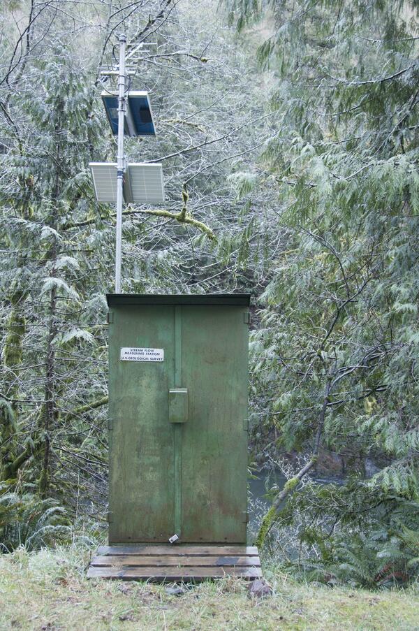
A USGS streamflow gaging station is used to collect water data
A USGS streamflow gaging station is used to collect water dataA U.S. Geological Survey streamflow gaging station collects water data on the Trask River. The Trask River gage is located near Tillamook, Ore. and has been in operation for 17 years.

USGS streamgage on the Trask River
Trask River stage, discharge, and water-quality data are collected and used together to help monitor the current health of the river. Data from the river are sent to equipment in the gage house, where it is stored then transmitted to USGS servers.
Trask River stage, discharge, and water-quality data are collected and used together to help monitor the current health of the river. Data from the river are sent to equipment in the gage house, where it is stored then transmitted to USGS servers.