
This image from the European Space Agency's Sentinel-2A satellite offers a breathtaking view of Crater Lake National Park in southern Oregon. It offers something equally important to park managers, scientists, and anyone else interested in land cover change—a view that is highly similar and complementary to Landsat acquisitions.
Images
Images intro.
Filter Total Items: 24

Crater Lake Image Shows Potential of Sentinel-2A
This image from the European Space Agency's Sentinel-2A satellite offers a breathtaking view of Crater Lake National Park in southern Oregon. It offers something equally important to park managers, scientists, and anyone else interested in land cover change—a view that is highly similar and complementary to Landsat acquisitions.

Photo of Crater Lake with oblique bathymetric image of the caldera ...
Photo of Crater Lake with oblique bathymetric image of the caldera ...Photo of Crater Lake with oblique bathymetric image of the caldera floor beneath the lake's surface. Oregon
Photo of Crater Lake with oblique bathymetric image of the caldera ...
Photo of Crater Lake with oblique bathymetric image of the caldera ...Photo of Crater Lake with oblique bathymetric image of the caldera floor beneath the lake's surface. Oregon

Map showing one-year probability of accumulation of 1 centimeter
Map showing one-year probability of accumulation of 1 centimeterMap showing one-year probability of accumulation of 1 centimeter (0.4 inch) or more of tephra from eruptions of volcanoes in the Cascade Range.
By
Natural Hazards Mission Area, Volcano Hazards Program, California Volcano Observatory, Cascades Volcano Observatory, Crater Lake, Glacier Peak, Lassen Volcanic Center, Medicine Lake, Mount Adams, Mount Baker, Mount Hood, Mount Jefferson, Mount Rainier, Mount Shasta, Mount St. Helens, Newberry, Three Sisters

Mount Scott fire lookout tower near Crater Lake, OR
Mount Scott fire lookout tower near Crater Lake, ORMount Scott fire lookout tower near Crater Lake, Oregon. Tower houses seismic and deformation monitoring instruments.
Mount Scott fire lookout tower near Crater Lake, OR
Mount Scott fire lookout tower near Crater Lake, ORMount Scott fire lookout tower near Crater Lake, Oregon. Tower houses seismic and deformation monitoring instruments.

Crater Lake combined digital elevation and bathymetric map showing ...
Crater Lake combined digital elevation and bathymetric map showing ...Crater Lake partially fills the caldera that formed approximately 7,700 years ago during the eruption of a 12,000-ft-high volcano known as Mount Mazama.
Crater Lake combined digital elevation and bathymetric map showing ...
Crater Lake combined digital elevation and bathymetric map showing ...Crater Lake partially fills the caldera that formed approximately 7,700 years ago during the eruption of a 12,000-ft-high volcano known as Mount Mazama.

Crater Lake caldera rim view to north. Pumice Castle, orange spire ...
Crater Lake caldera rim view to north. Pumice Castle, orange spire ...Crater Lake caldera rim view to north. Pumice Castle, orange spire in center right, a near-vent deposit formed by 71ka Plinian tephra-fall deposit; cliff to left is Redcloud Cliff lava flow.

Andesite lava flow of Kerr Notch (near Sun Creek) developed columna...
Andesite lava flow of Kerr Notch (near Sun Creek) developed columna...Andesite lava flow of Kerr Notch (near Sun Creek) developed columnar joints as it cooled after it was deposited, Crater Lake, Oregon.
Andesite lava flow of Kerr Notch (near Sun Creek) developed columna...
Andesite lava flow of Kerr Notch (near Sun Creek) developed columna...Andesite lava flow of Kerr Notch (near Sun Creek) developed columnar joints as it cooled after it was deposited, Crater Lake, Oregon.
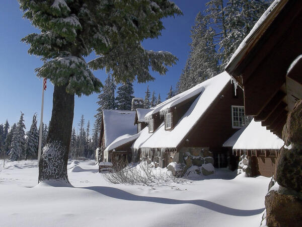
Steel Information Center in Winter at Crater Lake National Park.
Steel Information Center in Winter at Crater Lake National Park.Steel Information Center in Winter at Crater Lake National Park.
Steel Information Center in Winter at Crater Lake National Park.
Steel Information Center in Winter at Crater Lake National Park.Steel Information Center in Winter at Crater Lake National Park.

Pinnacles formed in Mazama pyroclastic flow deposit as erosion reve...
Pinnacles formed in Mazama pyroclastic flow deposit as erosion reve...Pinnacles formed in Mazama pyroclastic flow deposit as erosion revealed fumarole chimneys that formed shortly after 7,700 ka eruption released gas, Crater Lake.

Crater Lake panorama seen from the lake's southern shore. Wizard Is...
Crater Lake panorama seen from the lake's southern shore. Wizard Is...Crater Lake panorama seen from the lake's southern shore. Wizard Island is cone in western portion of lake. Oregon
Crater Lake panorama seen from the lake's southern shore. Wizard Is...
Crater Lake panorama seen from the lake's southern shore. Wizard Is...Crater Lake panorama seen from the lake's southern shore. Wizard Island is cone in western portion of lake. Oregon

Crater Lake, Chaski Bay. Talus slope sits on flat top of massive sl...
Crater Lake, Chaski Bay. Talus slope sits on flat top of massive sl...View southwest of Garfield Peak and Eagle Crags above Chaski Bay. Cliffs at caldera rim are andesite of Applegate Peak (unit aa; ca. 210-270 ka), overlain by two thin flows of andesite of Garfield Peak at top center (unit ag; 224 ±9 ka). Talus rests on flat top of massive slide block that consists of altered lavas of units aa, ak(?), and db(?).

Sun Creek Valley with Crater Lake in background, aerial view lookin...
Sun Creek Valley with Crater Lake in background, aerial view lookin...Morning aerial view looking northwest up the valley of Sun Creek. Applegate Peak caps the prominent rock wall of the west side of Sun Notch at the caldera rim. Northwest caldera wall is visible on opposite side of Crater Lake through Sun Notch. Grayback Ridge in foreground is thick lava of pre-Mazama rhyodacite (410-460 ka).

Eruptions in the Cascade Range during the past 4000 years. USGS GIP 64
Eruptions in the Cascade Range during the past 4000 years. USGS GIP 64Eruptions in the Cascade Range during the past 4000 years. USGS GIP 64
Eruptions in the Cascade Range during the past 4000 years. USGS GIP 64
Eruptions in the Cascade Range during the past 4000 years. USGS GIP 64Eruptions in the Cascade Range during the past 4000 years. USGS GIP 64

Crater Lake Caldera with Wizard Island cinder cone and lava flows, ...
Crater Lake Caldera with Wizard Island cinder cone and lava flows, ...Crater Lake Caldera with Wizard Island cinder cone and lava flows, some of the youngest features in the caldera as seen from Merriam Point. Viewed toward the south. Oregon

Crater Lake is the remnant of Mount Mazama, which erupted catastrop...
Crater Lake is the remnant of Mount Mazama, which erupted catastrop...Crater Lake is the remnant of Mount Mazama, which erupted catastrophically 7,700 years ago to form the caldera.Wizard Island in lake and Mount Scott is peak on right shore. View from south. Oregon

Crater Lake from the air viewed from SW. Wizard Island is the coni...
Crater Lake from the air viewed from SW. Wizard Island is the coni...Crater Lake from the air viewed from the southwest. Wizard Island is the conical mound in the lake and Mount Scott is the peak beyond the lake. Oregon
Crater Lake from the air viewed from SW. Wizard Island is the coni...
Crater Lake from the air viewed from SW. Wizard Island is the coni...Crater Lake from the air viewed from the southwest. Wizard Island is the conical mound in the lake and Mount Scott is the peak beyond the lake. Oregon

Crater Lake bathymetric map showing the geology of the caldera floo...
Crater Lake bathymetric map showing the geology of the caldera floo...Crater Lake bathymetric map showing the geology of the caldera floor with post-caldera eruptive units. Oregon
Crater Lake bathymetric map showing the geology of the caldera floo...
Crater Lake bathymetric map showing the geology of the caldera floo...Crater Lake bathymetric map showing the geology of the caldera floor with post-caldera eruptive units. Oregon

Crater Lake, Oregon
USGS scientist collecting samples at Crater Lake, Oregon.
USGS scientist collecting samples at Crater Lake, Oregon.

Mount Thielsen (2,799 m or 9,182 ft) is an extinct volcano north of...
Mount Thielsen (2,799 m or 9,182 ft) is an extinct volcano north of...Mount Thielsen (2,799 m or 9,182 ft) is an extinct volcano north of Crater Lake, Oregon that last erupted 250,000 years ago. Aerial view.
Mount Thielsen (2,799 m or 9,182 ft) is an extinct volcano north of...
Mount Thielsen (2,799 m or 9,182 ft) is an extinct volcano north of...Mount Thielsen (2,799 m or 9,182 ft) is an extinct volcano north of Crater Lake, Oregon that last erupted 250,000 years ago. Aerial view.

Pyroclastic flow deposit from 7,700 year old Mount Mazama eruption ...
Pyroclastic flow deposit from 7,700 year old Mount Mazama eruption ...These pyroclastic-flow deposits of the climactic eruption of Mount Mazama, during which Crater Lake caldera formed, are eroded into spectacular spires at The Pinnacles on Wheeler Creek.

Pinnacles left by erosion of fumaroles that formed as layered pyroc...
Pinnacles left by erosion of fumaroles that formed as layered pyroc...Pinnacles left by erosion of fumaroles that formed as layered pyroclastic flow deposit released gas and solidified into chimneys that eventually eroded, Crater Lake, Oregon.