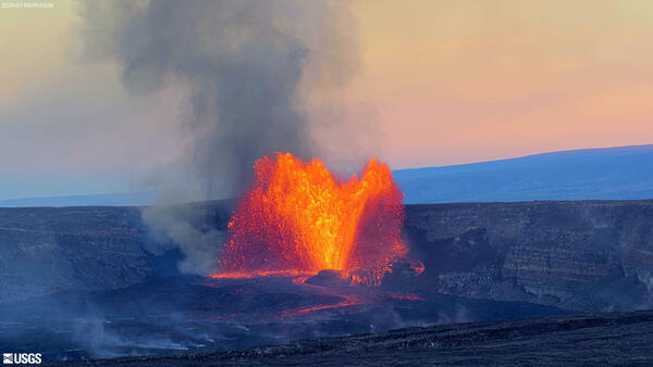
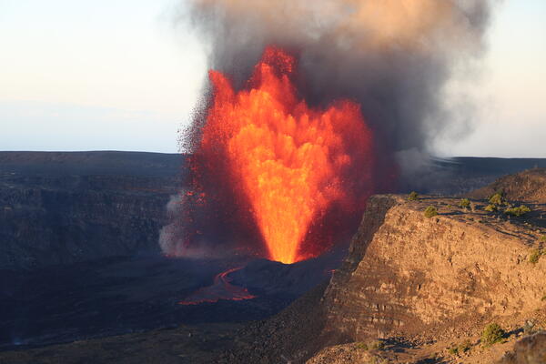
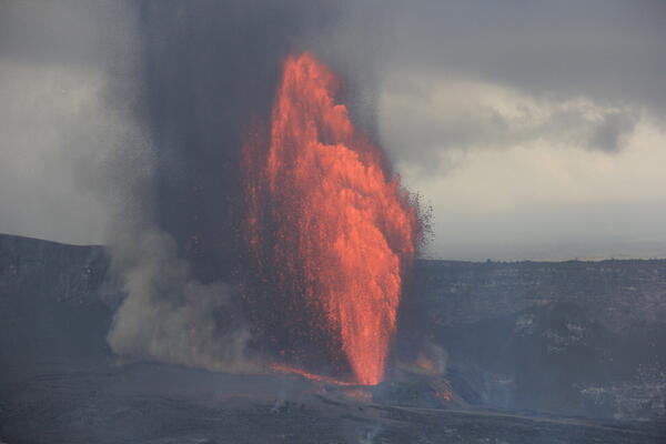
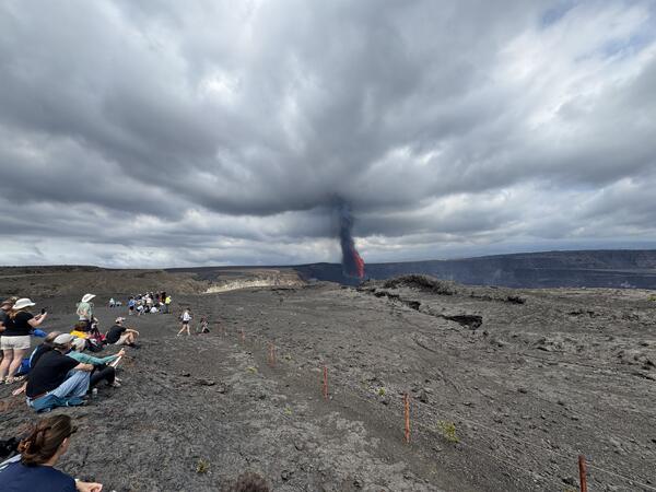
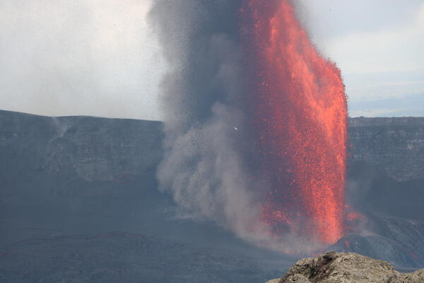
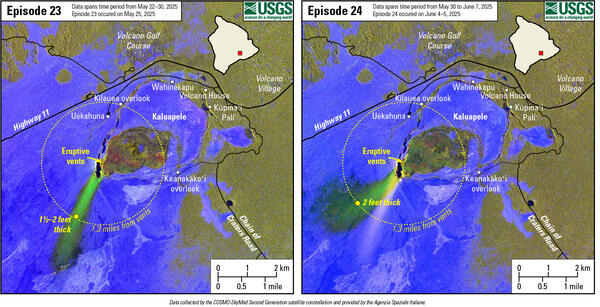
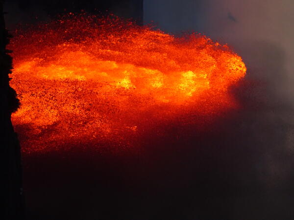
U.S. flag

An official website of the United States government

Images

Kīlauea images of eruptive activity, field work, and more.

Filter Total Items: 2928
Scientist looks through a laser rangefinder at steaming vents within a crater to make measurements
Field visit following episode 13 fountaining

A USGS Hawaiian Volcano Observatory geologist uses a handheld laser rangefinder on the southwest rim of Kaluapele (Kīlauea summit caldera) to measure the height of the recently active cones within Halema‘uma‘u. USGS photo taken on March 12, 2025, by M. Patrick.

A USGS Hawaiian Volcano Observatory geologist uses a handheld laser rangefinder on the southwest rim of Kaluapele (Kīlauea summit caldera) to measure the height of the recently active cones within Halema‘uma‘u. USGS photo taken on March 12, 2025, by M. Patrick.

Zoomed in view of two inactive lava vents with white volcanic gas plumes being emitted
Kīlauea south vent cone within Halema‘uma‘u

A closeup view of the south cone at the summit of Kīlauea, showing the semi-molten nature of the cone flanks. During fountaining, lava accumulates on the cone's flanks at such a high rate that the material remains hot and semi-molten, despite the appearance of cooled, solid material on the surface.

A closeup view of the south cone at the summit of Kīlauea, showing the semi-molten nature of the cone flanks. During fountaining, lava accumulates on the cone's flanks at such a high rate that the material remains hot and semi-molten, despite the appearance of cooled, solid material on the surface.

An orange broken bucket is partially buried by a thick blanket of gray/brown tephra
Tephra blanket from Kīlauea summit fountaining episodes

An orange five-gallon plastic bucket, secured by heavy weights, was one of several used to collect tephra from the ongoing lava fountaining at the summit of Kīlauea. The episode 13 fountaining, however, cast large bombs (some of them molten) in this particular area, battering the ground.

An orange five-gallon plastic bucket, secured by heavy weights, was one of several used to collect tephra from the ongoing lava fountaining at the summit of Kīlauea. The episode 13 fountaining, however, cast large bombs (some of them molten) in this particular area, battering the ground.

A scientist works on servicing volcano monitoring equipment with steaming volcanic vents in background
HVO geologist services webcam day after episode 13 at Kīlauea

On March 12, a USGS Hawaiian Volcano Observatory geologist on the southwest rim of Kaluapele (Kīlauea summit caldera) serviced the S2cam webcam. A plume of water vapor and volcanic gas rises from the two vents of the ongoing eruption within Halema‘uma‘u crater, one day after the 13th episode of the eruption. USGS photo by N. Deligne.

On March 12, a USGS Hawaiian Volcano Observatory geologist on the southwest rim of Kaluapele (Kīlauea summit caldera) serviced the S2cam webcam. A plume of water vapor and volcanic gas rises from the two vents of the ongoing eruption within Halema‘uma‘u crater, one day after the 13th episode of the eruption. USGS photo by N. Deligne.

A shovel is stuck into a thick deposit of gray/brown volcanic tephra
Crater Rim Drive tephra blanket

The section of Crater Rim Drive downwind of the recent fountaining, and in an area closed to the public due to volcanic hazards, has been covered by numerous layers of tephra in the past several months. The tire tracks are centered over the Crater Rim Drive roadway, where USGS scientists access critical volcano monitoring sites.

The section of Crater Rim Drive downwind of the recent fountaining, and in an area closed to the public due to volcanic hazards, has been covered by numerous layers of tephra in the past several months. The tire tracks are centered over the Crater Rim Drive roadway, where USGS scientists access critical volcano monitoring sites.

Orange lava fountains erupting from a crater wall
Episode 13 fountaining at Kīlauea summit

Episode 13 fountaining began early on March 11 and continued through an HVO helicopter overflight of the Kīlauea summit region around 10:00 a.m. Visibility was slightly hampered by passing showers.

Episode 13 fountaining began early on March 11 and continued through an HVO helicopter overflight of the Kīlauea summit region around 10:00 a.m. Visibility was slightly hampered by passing showers.

Geologist approaching an active lava flow
Episode 13 fountaining at Kīlauea summit

During a March 11 Hawaiian Volcano Observatory eruption monitoring flight at Kīlauea summit, scientists landed to make observations and collect samples. At the front of the channelized flow from the episode 13 north vent fountain in Halema‘uma‘u crater, a USGS geologist walks the flow margin to find a safe spot to collect a molten lava sample.

During a March 11 Hawaiian Volcano Observatory eruption monitoring flight at Kīlauea summit, scientists landed to make observations and collect samples. At the front of the channelized flow from the episode 13 north vent fountain in Halema‘uma‘u crater, a USGS geologist walks the flow margin to find a safe spot to collect a molten lava sample.

Color photograph of lava fountaining
March 11, 2025 — Episode 13 of lava fountaining at Kīlauea summit

In this image captured on USGS Hawaiian Volcano Observatory research camera S2cam, fountains erupt with similar heights from the north and south vents during episode 13 on March 11, 2025. The maximum fountain height during this episode was 215 meters (700 feet), measured at the north vent. USGS photo. 

In this image captured on USGS Hawaiian Volcano Observatory research camera S2cam, fountains erupt with similar heights from the north and south vents during episode 13 on March 11, 2025. The maximum fountain height during this episode was 215 meters (700 feet), measured at the north vent. USGS photo. 

Lava flow with silver crust and hot molten lava visible underneath
Episode 13 fountaining at Kīlauea summit

On the Halema‘uma‘u crater floor, the front of a fast-moving channelized lava flow from the north vent fountain was composed of slabby pāhoehoe. USGS photo taken on March 11, 2025, by M. Patrick.

On the Halema‘uma‘u crater floor, the front of a fast-moving channelized lava flow from the north vent fountain was composed of slabby pāhoehoe. USGS photo taken on March 11, 2025, by M. Patrick.

Close up view of lava fountain building up a cone around it
Episode 13 fountaining at Kīlauea summit

A telephoto view of the northern vent fountain within Halema‘uma‘u crater. The steep septum separating the north and south fountains was under constant barrage today by molten lava falling from the fountains, with the steep walls on the inside of the cones in a state of constant dripping and flowing back into crater. USGS photo by M.

A telephoto view of the northern vent fountain within Halema‘uma‘u crater. The steep septum separating the north and south fountains was under constant barrage today by molten lava falling from the fountains, with the steep walls on the inside of the cones in a state of constant dripping and flowing back into crater. USGS photo by M.

Close up photo of a scientist collecting eruption data
Episode 13 fountaining at Kīlauea summit

A USGS geologist uses a handheld laser rangefinder to measure eruption features during the 13th episode of the Kīlauea summit eruption. USGS photo taken on March 11 from the western rim of Halema‘uma‘u by M. Patrick.

A USGS geologist uses a handheld laser rangefinder to measure eruption features during the 13th episode of the Kīlauea summit eruption. USGS photo taken on March 11 from the western rim of Halema‘uma‘u by M. Patrick.

A USGS vehicle is seen on top of a road covered by volcanic tephra
Episode 13 fountaining at Kīlauea summit

The closed portion of Crater Rim Drive, just west of the active vents, has been covered by a deep layer of tephra falling out downwind from the recent lava fountains. In this section, the deposit is only a few inches thick, but farther down the road the tephra has accumulated into drifts that are up to about a half meter (or half a yard) thick.

The closed portion of Crater Rim Drive, just west of the active vents, has been covered by a deep layer of tephra falling out downwind from the recent lava fountains. In this section, the deposit is only a few inches thick, but farther down the road the tephra has accumulated into drifts that are up to about a half meter (or half a yard) thick.

Color photograph of lava fountain
March 11, 2025—North vent lava fountain

The north vent in Halema‘uma‘u crater was producing lava fountains about 160 feet (50 meters) high on the morning of March 11, with these fountains emerging from a small, sloshing pond inside the walls of the vent's spatter cone.

The north vent in Halema‘uma‘u crater was producing lava fountains about 160 feet (50 meters) high on the morning of March 11, with these fountains emerging from a small, sloshing pond inside the walls of the vent's spatter cone.

Lava fountains erupt from side-by-side vents within a crater
Episode 13 fountaining at Kīlauea summit

On March 11, HVO geologists observed episode 13 of the ongoing Kīlauea summit eruption from the western caldera rim. Lava fountains from the north vent (left) and south vent (right) were feeding channelized flows across the floor of Halema‘uma‘u crater. USGS photo by M. Patrick.

On March 11, HVO geologists observed episode 13 of the ongoing Kīlauea summit eruption from the western caldera rim. Lava fountains from the north vent (left) and south vent (right) were feeding channelized flows across the floor of Halema‘uma‘u crater. USGS photo by M. Patrick.

Color photograph of lava within vent
March 10, 2025—Low level spattering between eruptive episodes at Kīlauea volcano

On March 10, 2025, field teams saw low-level spattering from a small opening within north cone, active during recent eruptive episodes of the ongoing eruption at Halema‘uma‘u, Kīlauea volcano. This indicates that magma is very close to the surface. This photo was taken at 1:32 p.m. H.S.T., looking down nearly 600 feet (183 meters) above the crater floor.

On March 10, 2025, field teams saw low-level spattering from a small opening within north cone, active during recent eruptive episodes of the ongoing eruption at Halema‘uma‘u, Kīlauea volcano. This indicates that magma is very close to the surface. This photo was taken at 1:32 p.m. H.S.T., looking down nearly 600 feet (183 meters) above the crater floor.

Color map showing eruption extent
March 10, 2025—Kīlauea summit eruption reference map

This reference map depicts the Kīlauea summit eruption within Halema‘uma‘u crater that began on December 23, 2024. As of this posting on March 10, the eruption has had twelve episodes, with a thirteenth likely to occur the next 24 hours.

This reference map depicts the Kīlauea summit eruption within Halema‘uma‘u crater that began on December 23, 2024. As of this posting on March 10, the eruption has had twelve episodes, with a thirteenth likely to occur the next 24 hours.

Color photograph of volcanic plume rising within crater
March 6, 2025 — Gas plume a day after the end of episode 12 at Kīlauea's summit

A day after the end of episode 12 of the ongoing eruption at Kīlauea's summit, volcanic gas emissions continue from the recently active north and south cones on the western edge of Halema‘uma‘u. Most of the gas consists of water vapor (the primary volcanic gas), with sulfur dioxide (SO2) and other gases.

A day after the end of episode 12 of the ongoing eruption at Kīlauea's summit, volcanic gas emissions continue from the recently active north and south cones on the western edge of Halema‘uma‘u. Most of the gas consists of water vapor (the primary volcanic gas), with sulfur dioxide (SO2) and other gases.

Color photograph of volcanic plume
March 6, 2025 — Remnant of cone from June 2023 eruption surrounded by lava of current Kīlauea eruption

Lava flows from the eruption which started on December 23, 2024, within Halema‘uma‘u at the summit of Kīlauea volcano, have buried most of the cone from the June 2023 eruption, seen here in the upper middle of photo. This telephoto was taken north of the degassing north and south cones, and is looking toward to the south through the volcanic gas plume.

Lava flows from the eruption which started on December 23, 2024, within Halema‘uma‘u at the summit of Kīlauea volcano, have buried most of the cone from the June 2023 eruption, seen here in the upper middle of photo. This telephoto was taken north of the degassing north and south cones, and is looking toward to the south through the volcanic gas plume.

Color photograph of volcanic particle on melted plastic bottle
March 6, 2025 — Damage from a lava bomb ejected during episode 12 lava fountaining

USGS Hawaiian Volcano Observatory (HVO) collects tephra from lava fountaining in buckets. Each bucket has a weight inside to prevent high winds from blowing the bucket away; some of these weights are milk jugs filled with sand.

USGS Hawaiian Volcano Observatory (HVO) collects tephra from lava fountaining in buckets. Each bucket has a weight inside to prevent high winds from blowing the bucket away; some of these weights are milk jugs filled with sand.

Color photograph of lava flows and eruptive vents
March 5, 2025 — Views from the floor of Halemaʻumaʻu, Kīlauea volcano

A view across of the new lava flows on the floor of Halemaʻumaʻu, looking towards the active north and south vents on the west wall of the crater. USGS photo by D. Downs on March 5, 2025.

Color photo of lava fountain
March 4, 2025 — Lava textures at Kīlauea

A telephoto image of episode 12's lava fountains show the varied textures of motel material as it leaves the vent. In the fountain you can see the formation of both cinder and spatter. Cinders are glassy, vesicular, pyroclastic fragments that fall to the ground in an essentially solid condition. These are the smaller, darker particles in the figure.

A telephoto image of episode 12's lava fountains show the varied textures of motel material as it leaves the vent. In the fountain you can see the formation of both cinder and spatter. Cinders are glassy, vesicular, pyroclastic fragments that fall to the ground in an essentially solid condition. These are the smaller, darker particles in the figure.

Was this page helpful?