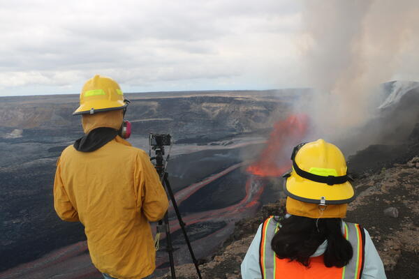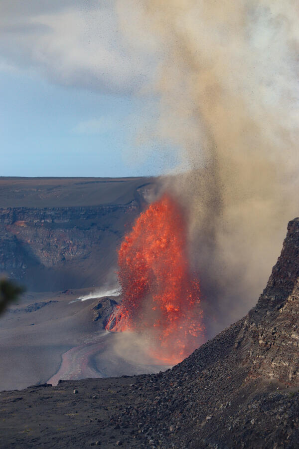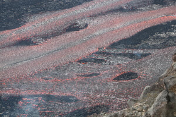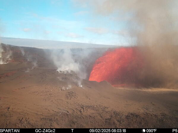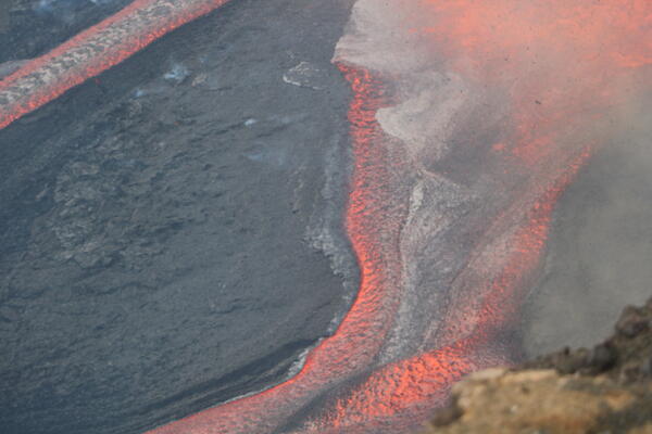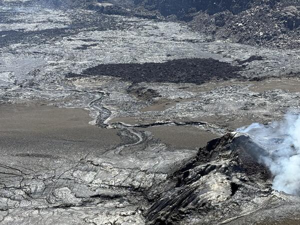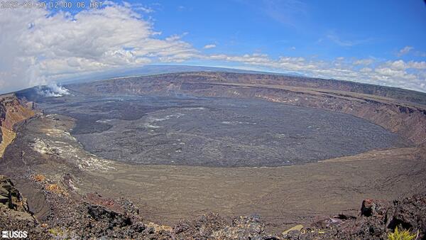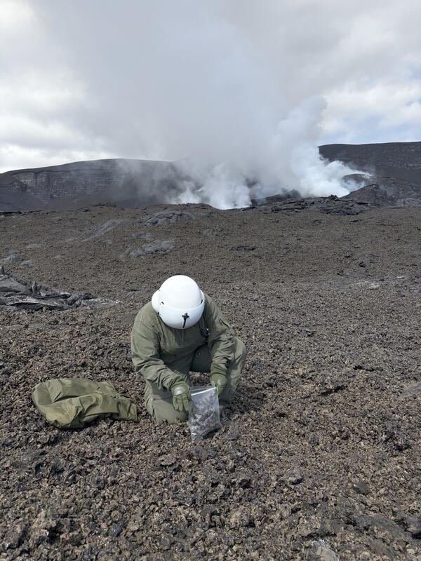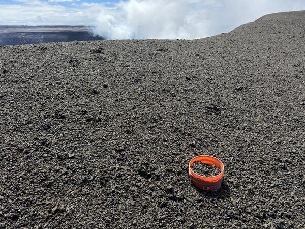
Upper left: a dusty lava puahiohio (at right in frame) above the main 2022 Mauna Loa lava flow on 2 December 2022, with the eruptive plume further in the background (at left in frame). Upper right: a lava puahiohio rips up the crust of the Kīlauea summit lava lake on 7 June 2023.
Images
Kīlauea images of eruptive activity, field work, and more.
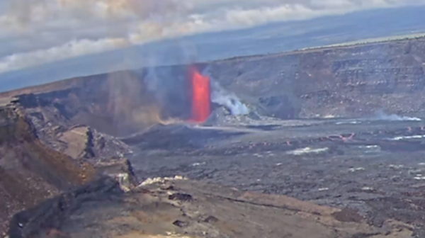
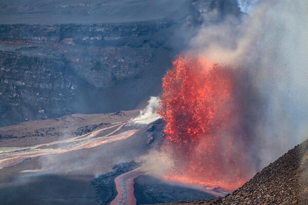
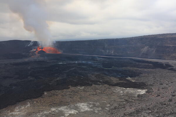
Upper left: a dusty lava puahiohio (at right in frame) above the main 2022 Mauna Loa lava flow on 2 December 2022, with the eruptive plume further in the background (at left in frame). Upper right: a lava puahiohio rips up the crust of the Kīlauea summit lava lake on 7 June 2023.
The left map shows the tephra fall associated with Kīlauea's episodic summit eruption, from December 2024-December 2025. Tephra is a generic word for any material erupted by a volcano that travels through the air before landing on the ground.
November 25, 2025—Kīlauea summit eruption episode 37
November 25, 2025—Kīlauea summit eruption episode 37Episode 37 lava fountaining occurred On November 25, from 2:30 p.m. to 11:39 p.m., totaling just over 9 hours. Fountains were limited to the north vent, which sent lava flows over a large portion of the crater floor. Fountain heights reached 500-600 ft (150-180 meters). The south vent showed only weak spattering and flaming. USGS photo by M. Patrick.
November 25, 2025—Kīlauea summit eruption episode 37
November 25, 2025—Kīlauea summit eruption episode 37Episode 37 lava fountaining occurred On November 25, from 2:30 p.m. to 11:39 p.m., totaling just over 9 hours. Fountains were limited to the north vent, which sent lava flows over a large portion of the crater floor. Fountain heights reached 500-600 ft (150-180 meters). The south vent showed only weak spattering and flaming. USGS photo by M. Patrick.
November 25, 2025—Kīlauea summit eruption episode 37 lava fountains
November 25, 2025—Kīlauea summit eruption episode 37 lava fountainsFollowing several days of precursory overflows and low dome fountaining, episode 37 of the Kīlauea summit eruption began yesterday at 2:30 p.m. with lava fountaining from the north vent. A wide fountain developed, eventually reaching heights of 500-600 ft (150-180 meters), sending flows across a broad portion of the crater floor.
November 25, 2025—Kīlauea summit eruption episode 37 lava fountains
November 25, 2025—Kīlauea summit eruption episode 37 lava fountainsFollowing several days of precursory overflows and low dome fountaining, episode 37 of the Kīlauea summit eruption began yesterday at 2:30 p.m. with lava fountaining from the north vent. A wide fountain developed, eventually reaching heights of 500-600 ft (150-180 meters), sending flows across a broad portion of the crater floor.
November 25, 2025—Kīlauea summit eruption episode 37 lava flow
November 25, 2025—Kīlauea summit eruption episode 37 lava flowThe telephoto shows lava flowing east across the floor of Halemaʻumaʻu crater, fed by the lava fountains in the west part of the crater. Preliminary estimates suggest that approximately 6 million cubic meters (7.8 million cubic yards) of lava were erupted during episode 37, based on ground deformation data. USGS photo by M. Patrick.
November 25, 2025—Kīlauea summit eruption episode 37 lava flow
November 25, 2025—Kīlauea summit eruption episode 37 lava flowThe telephoto shows lava flowing east across the floor of Halemaʻumaʻu crater, fed by the lava fountains in the west part of the crater. Preliminary estimates suggest that approximately 6 million cubic meters (7.8 million cubic yards) of lava were erupted during episode 37, based on ground deformation data. USGS photo by M. Patrick.
November 25, 2025—Kīlauea summit eruption reference map
November 25, 2025—Kīlauea summit eruption reference mapThis reference map depicts the Kīlauea summit eruption within Halema‘uma‘u crater that began on December 23, 2024. The data for this map were collected during a Hawaiian Volcano Observatory helicopter overflight on November 24, 2025; as such, the provided statistics are reflective of the first thirty-six episodes of the eruption through November 9.
November 25, 2025—Kīlauea summit eruption reference map
November 25, 2025—Kīlauea summit eruption reference mapThis reference map depicts the Kīlauea summit eruption within Halema‘uma‘u crater that began on December 23, 2024. The data for this map were collected during a Hawaiian Volcano Observatory helicopter overflight on November 24, 2025; as such, the provided statistics are reflective of the first thirty-six episodes of the eruption through November 9.
November 25, 2025—Monitoring Kīlauea summit eruption episode 37
November 25, 2025—Monitoring Kīlauea summit eruption episode 37USGS Hawaiian Volcano Observatory scientists document lava fountains and lava flows during episode 37 of the ongoing Kīlauea summit eruption in Halemaʻumaʻu crater. From the rim of the crater, scientists can use a laser rangefinding device to approximately measure the lava fountain heights, and distance the lava flows have travelled. USGS photo by M.
November 25, 2025—Monitoring Kīlauea summit eruption episode 37
November 25, 2025—Monitoring Kīlauea summit eruption episode 37USGS Hawaiian Volcano Observatory scientists document lava fountains and lava flows during episode 37 of the ongoing Kīlauea summit eruption in Halemaʻumaʻu crater. From the rim of the crater, scientists can use a laser rangefinding device to approximately measure the lava fountain heights, and distance the lava flows have travelled. USGS photo by M.
November 25, 2025—Kīlauea summit eruption episode 37 lava flows
November 25, 2025—Kīlauea summit eruption episode 37 lava flowsTelephoto view of lava flows on the floor of Halemaʻumaʻu crater. These lava flows were erupted during episode 37 of lava fountaining at the summit of Kīlauea, which was active for about 9 hours on November 25. USGS photo by M. Patrick.
November 25, 2025—Kīlauea summit eruption episode 37 lava flows
November 25, 2025—Kīlauea summit eruption episode 37 lava flowsTelephoto view of lava flows on the floor of Halemaʻumaʻu crater. These lava flows were erupted during episode 37 of lava fountaining at the summit of Kīlauea, which was active for about 9 hours on November 25. USGS photo by M. Patrick.
USGS Hawaiian Volcano Observatory scientists landed briefly on Halema‘uma‘u crater floor on November 24, 2025, during a Kīlauea summit monitoring overflight.
November 24, 2025 — The growing puʻu on the rim of Halema‘uma‘u
November 24, 2025 — The growing puʻu on the rim of Halema‘uma‘uThis aerial view looking to the southeast shows the volcanic gas plume being emitted from the vents of the ongoing Halema‘uma‘u eruption at Kīlauea summit.
November 24, 2025 — The growing puʻu on the rim of Halema‘uma‘u
November 24, 2025 — The growing puʻu on the rim of Halema‘uma‘uThis aerial view looking to the southeast shows the volcanic gas plume being emitted from the vents of the ongoing Halema‘uma‘u eruption at Kīlauea summit.
November 24, 2025 — View into the Halema‘uma‘u vents
November 24, 2025 — View into the Halema‘uma‘u ventsAn aerial view looking down into the south vent (center) of the ongoing Kīlauea summit eruption within Halema‘uma‘u crater. A tiny spot of orange incandescent lava was visible deep in the south vent on the morning of November 24 during a USGS Hawaiian Volcano Observatory monitoring helicopter overflight.
November 24, 2025 — View into the Halema‘uma‘u vents
November 24, 2025 — View into the Halema‘uma‘u ventsAn aerial view looking down into the south vent (center) of the ongoing Kīlauea summit eruption within Halema‘uma‘u crater. A tiny spot of orange incandescent lava was visible deep in the south vent on the morning of November 24 during a USGS Hawaiian Volcano Observatory monitoring helicopter overflight.
November 24, 2025 — Geologist collects sample within Halema‘uma‘u
November 24, 2025 — Geologist collects sample within Halema‘uma‘uOn November 24, a USGS Hawaiian Volcano Observatory helicopter overflight was able to land on the floor of Halema‘uma‘u crater for scientists to collect a sample of cooled lava from a recent overflow of the Kīlauea summit eruptive vents.
November 24, 2025 — Geologist collects sample within Halema‘uma‘u
November 24, 2025 — Geologist collects sample within Halema‘uma‘uOn November 24, a USGS Hawaiian Volcano Observatory helicopter overflight was able to land on the floor of Halema‘uma‘u crater for scientists to collect a sample of cooled lava from a recent overflow of the Kīlauea summit eruptive vents.
November 24, 2025 — View into the Halema‘uma‘u vents
November 24, 2025 — View into the Halema‘uma‘u ventsA telephoto aerial view looking down into the north vent (center) of the ongoing Kīlauea summit eruption within Halema‘uma‘u crater. Orange incandescent lava is visible deep in the vent. Lava overflows from both vents over the past few days produced shiny new Pāhoehoe flows (bottom center and left side of photo).
November 24, 2025 — View into the Halema‘uma‘u vents
November 24, 2025 — View into the Halema‘uma‘u ventsA telephoto aerial view looking down into the north vent (center) of the ongoing Kīlauea summit eruption within Halema‘uma‘u crater. Orange incandescent lava is visible deep in the vent. Lava overflows from both vents over the past few days produced shiny new Pāhoehoe flows (bottom center and left side of photo).
November 21, 2025 — Scientists on floor of Halema‘uma‘u
November 21, 2025 — Scientists on floor of Halema‘uma‘uWith permission from Hawai‘i Volcanoes National Park, USGS Hawaiian Volcano Observatory scientists landed briefly on the floor of Halema‘uma‘u crater on November 21 to collect lava samples from Kīlauea summit eruption episodes 34, 35, and 36.
November 21, 2025 — Scientists on floor of Halema‘uma‘u
November 21, 2025 — Scientists on floor of Halema‘uma‘uWith permission from Hawai‘i Volcanoes National Park, USGS Hawaiian Volcano Observatory scientists landed briefly on the floor of Halema‘uma‘u crater on November 21 to collect lava samples from Kīlauea summit eruption episodes 34, 35, and 36.
November 21, 2025 — Cold lava sampling on floor of Halema‘uma‘u
November 21, 2025 — Cold lava sampling on floor of Halema‘uma‘uOn November 21, USGS Hawaiian Volcano Observatory scientists collected solid lava samples from the floor of Halema‘uma‘u crater at the summit of Kīlauea. All sampling in this area, which is significant to native Hawaiian communities, is done with permission from Hawai‘i Volcanoes National Park.
November 21, 2025 — Cold lava sampling on floor of Halema‘uma‘u
November 21, 2025 — Cold lava sampling on floor of Halema‘uma‘uOn November 21, USGS Hawaiian Volcano Observatory scientists collected solid lava samples from the floor of Halema‘uma‘u crater at the summit of Kīlauea. All sampling in this area, which is significant to native Hawaiian communities, is done with permission from Hawai‘i Volcanoes National Park.
November 21, 2025 — Aerial view of Halema‘uma‘u north vent
November 21, 2025 — Aerial view of Halema‘uma‘u north ventOn November 21, USGS Hawaiian Volcano Observatory scientists conducted an aerial overflight of the eruptive vent complex at the summit of Kīlauea. Roiling lava ponds were visible in both the north and south vents during the overflight; the north vent's incandescent pond barely visible in this aerial photo looking down from the north.
November 21, 2025 — Aerial view of Halema‘uma‘u north vent
November 21, 2025 — Aerial view of Halema‘uma‘u north ventOn November 21, USGS Hawaiian Volcano Observatory scientists conducted an aerial overflight of the eruptive vent complex at the summit of Kīlauea. Roiling lava ponds were visible in both the north and south vents during the overflight; the north vent's incandescent pond barely visible in this aerial photo looking down from the north.
This photo, taken on November 18 from the south rim of Halemaʻumaʻu crater, shows slumping of material from the hill formed by fallout from the recent lava fountains at Kīlauea summit. The v3cam livestream camera is visible on the rim of the crater in the middle left of the image. USGS photo by M. Patrick.
November 17, 2025 — Road marker damaged during episode 36 of Kīlauea's ongoing summit eruption
November 17, 2025 — Road marker damaged during episode 36 of Kīlauea's ongoing summit eruptionThis plastic road marker shown on the left side of this photo was found on the side of Crater Rim Drive within the hazardous closed area of Hawai‘i Volcanoes National Park, downwind of the episodically erupting vents within Halema‘uma‘u crater.
November 17, 2025 — Road marker damaged during episode 36 of Kīlauea's ongoing summit eruption
November 17, 2025 — Road marker damaged during episode 36 of Kīlauea's ongoing summit eruptionThis plastic road marker shown on the left side of this photo was found on the side of Crater Rim Drive within the hazardous closed area of Hawai‘i Volcanoes National Park, downwind of the episodically erupting vents within Halema‘uma‘u crater.
November 17, 2025 — Measuring a crack in Crater Rim Drive
November 17, 2025 — Measuring a crack in Crater Rim DriveThe west portion of Crater Rim Drive in Hawaiʻi Volcanoes National Park was damaged during the Kīlauea summit collapse of 2018. This area has remained closed to the public, being impacted by tephrafall and volcanic gas during recent eruptions. U.S.
November 17, 2025 — Measuring a crack in Crater Rim Drive
November 17, 2025 — Measuring a crack in Crater Rim DriveThe west portion of Crater Rim Drive in Hawaiʻi Volcanoes National Park was damaged during the Kīlauea summit collapse of 2018. This area has remained closed to the public, being impacted by tephrafall and volcanic gas during recent eruptions. U.S.
November 17, 2025 — Wooden post damaged by episode 36 of ongoing Kīlauea eruption
November 17, 2025 — Wooden post damaged by episode 36 of ongoing Kīlauea eruptionThis wooden post used to mark the side of Crater Rim Drive within a hazardous closed area of Hawai‘i Volcanoes National Park. The post has been slowly buried by tephra from lava fountains that have been episodically active during the ongoing eruption of Kīlauea at Halema‘uma‘u that started on December 23, 2025.
November 17, 2025 — Wooden post damaged by episode 36 of ongoing Kīlauea eruption
November 17, 2025 — Wooden post damaged by episode 36 of ongoing Kīlauea eruptionThis wooden post used to mark the side of Crater Rim Drive within a hazardous closed area of Hawai‘i Volcanoes National Park. The post has been slowly buried by tephra from lava fountains that have been episodically active during the ongoing eruption of Kīlauea at Halema‘uma‘u that started on December 23, 2025.
November 17, 2025 — Checking Kīlauea summit monitoring equipment
November 17, 2025 — Checking Kīlauea summit monitoring equipmentA U.S. Geological Survey Hawaiian Volcano Observatory geologists checks the status of one of the Kīlauea monitoring stations downwind of the active vents in Halemaʻumaʻu. This station has been buried incrementally by tephra as a result of lava fountaining, and solar panels were damaged by tephra impact. USGS photo by N. Kohagura.
November 17, 2025 — Checking Kīlauea summit monitoring equipment
November 17, 2025 — Checking Kīlauea summit monitoring equipmentA U.S. Geological Survey Hawaiian Volcano Observatory geologists checks the status of one of the Kīlauea monitoring stations downwind of the active vents in Halemaʻumaʻu. This station has been buried incrementally by tephra as a result of lava fountaining, and solar panels were damaged by tephra impact. USGS photo by N. Kohagura.