| Episode Number | Start Date/Time (HST) | Pause Date/Time (HST) | Eruptive Episode Duration | Pause Duration Following Episode | Approximate Maximum Fountain Height (meters) | Approximate volume of lava erupted (million cubic meters) | Notes |
| 1 | December 23, 2024 - 2:20 a.m. | December 23, 2024 - 4 p.m. | 14 hours | 16 hours | 158 | 9.3 | Fissures open, eruption focuses on north and south vents |
| 2 | December 24, 2024 - 8 a.m. | December 25, 2024 - 11 a.m. | 27 hours | 21 hours | 95 | 4.7 | Several vents reactivate |
| 3 | December 26, 2024 - 8 a.m. | January 3, 2025 - 8:30 p.m. | 8.5 days | 12 days | 86 | 13.0 | Several vents reactivate, activity focuses at north and south vents |
| 4 | January 15, 2025 - 9 a.m. | January 18, 2025 - 10:10 a.m. | 3 days | 4 days | 95 | 6.5 | North and south vents active |
| 5 | January 22, 2025 - 2:30 p.m. | January 23, 2025 - 4:30 a.m. | 14 hours | 2 days | 41 | 1.0 | North vent active only |
| 6 | January 24, 2025 - 11:28 p.m. | January 25, 2025 - 12:36 p.m. | 13 hours | 2 days | 70 | 1.1 | North vent active only |
| 7 | January 27, 2025 - 6:41 p.m. | January 28, 2025 - 10:41 a.m. | 16 hours | 6 days | 89 | 2.9 | North and south vents active |
| 8 | February 3, 2025 - 9:52 p.m. | February 4, 2025 - 7:23 p.m. | 22 hours | 7 days | 114 | 4.6 | North and south vents active |
| 9 | February 11, 2025 - 10:16 a.m. | February 12, 2025 - 8:43 a.m. | 22 hours | 7 days | 135 | 5.2 | North and south vents active |
| 10 | February 19, 2025 - 8:22 p.m. | February 20, 2025 - 9:18 a.m. | 13 hours | 5 days | 146 | 2.5 | North vent active only |
| 11 | February 25, 2025 - 6:26 p.m. | February 26, 2025 - 7:06 a.m. | 13 hours | 6 days | 157 | 4.0 | North and south vents active |
| 12 | March 4, 2025 - 7:30 a.m. | March 5, 2025 - 10:37 a.m. | 27 hours | 6 days | 176 | 4.4 | North and south vents active |
| 13 | March 11, 2025 - 2:36 a.m. | March 11, 2025 - 3:13 p.m. | 13 hours | 8 days | 215 | 5.5 | North and south vents active |
| 14 | March 19, 2025 - 9:26 a.m. | March 20, 2025 - 1:49 p.m. | 28 hours | 5 days | 225 | 2.4 | North and south vents active |
| 15 | March 25, 2025 - 12:04 p.m. | March 26, 2025 - 7:10 p.m. | 31 hours | 5 days | 322 | 3.6 | North and south vents active; south vent inclined |
| 16 | March 31, 2025 - 10:57 p.m. | April 2, 2025 - 12:04 p.m. | 37 hours | 5 days | 326 | 6.0 | North and south vents active, south vent dominant |
| 17 | April 7, 2025 - 10:15 p.m. | April 9, 2025 - 9:45 a.m. | 35.5 hours | 13 days | 73 | 3.9 | North and south vents active |
| 18 | April 22, 2025 - 3:30 a.m. | April 22, 2025 - 1:28 p.m. | 10 hours | 9 days | 266 | 5.2 | Precursory low-level activity began on April 16, 2025 - 10:01 p.m.; north and south vents active, south vent dominant |
| 19 | May 1, 2025 - 9:28 p.m. | May 2, 2025 - 5:20 a.m. | 8 hours | 5 days | 126 | 2.8 | Precursory low-level activity began on May 1, 2025 - 11:49 a.m.; north vent active only |
| 20 | May 6, 2025 - 5:28 p.m. | May 6, 2025 - 9:28 p.m. | 4 hours | 5 days | 153 | 2.4 | Precursory low-level activity began on May 5, 2025 - 10:48 a.m.; north and south vents active, north vent dominant |
| 21 | May 11, 2025 - 12:45 p.m. | May 11, 2025 - 8:36 p.m. | 8 hours | 4 days | 217 | 3.1 | North vent primarily active |
| 22 | May 16, 2025 - 5:13 a.m. | May 16, 2025 - 3:29 p.m. | 10 hours | 9 days | 276 | 3.6
| North vent active only |
| 23 | May 25, 2025 - 4:15 p.m. | May 25, 2025 - 10:25 p.m. | 6 hours | 10 days | 345 | 4.6 | North and south vents active, north vent dominant |
| 24 | June 4, 2025 - 8:55 p.m. | June 5, 2025 - 4:28 a.m. | 7.5 hours | 6 days | 364 | 5.0 | North and south vents active, north vent dominant |
| 25 | June 11, 2025 - 11:57 a.m. | June 11, 2025 - 8:08 p.m. | 8 hours | 8 days | 350 | 5.3 | North and south vents active, north vent dominant |
| 26 | June 20, 2025 - 1:40 a.m. | June 20, 2025 - 10:25 a.m. | 9 hours | 9 days | 371 | 6.6 | North and south vents active, north vent dominant |
| 27 | June 29, 2025 - 9:05 a.m. | June 29, 2025 - 7:54 p.m. | 11 hours | 8 days | 332 | 5.9 | North and south vents active, north vent dominant |
| 28 | July 9, 2025 - 4:10 a.m. | July 9 - 1:20 p.m. | 9 hours | 11 days | 321 | 5.2 | Only north vent active |
| 29 | July 20, 2025 - 5:15 a.m. | July 20 - 6:35 p.m. | 13 hours | 16 days | 63 | 6.7 | North and south vents active, north vent dominant |
| 30 | August 6, 2025 - 1:20 a.m. | August 6, 2025 - 12:55 p.m. | 12 hours | 16 days | 52 | 7.9 | North and south vents active, north vent dominant; new vent in southwest wall |
| 31 | August 22, 2025 - 2:04 p.m. | August 23, 2025 - 2:52 a.m. | 13 hours | 10 days | 88 | 7.6 | North and south vents active; north vent dominant and inclined. Intermediate vents also active |
| 32 | September 2, 2025 - 6:35 a.m. | September 2, 2025 - 8:01 p.m. | 12 hours | 16 days | 101 | 9.0 | North, south, and intermediate vents active; north vent inclined |
| 33 | September 19, 2025 - 3:11 a.m. | September 19, 2025 - 12:08 p.m. | 9 hours | 12 days | 249 | 5.7 | North and south vents active; north vent inclined |
| 34 | October 1, 2025 - 12:53 a.m. | October 1, 2025 - 7:03 a.m. | 6 hours | 17 days | 383 | 9.0 | North and south vents active; north vent inclined |
| 35 | October 17, 2025 - 8:05 p.m. | October 18, 2025 - 3:32 a.m. | 7 hours | 22 days | 479 | 10.2 | North and south vents active; north vent inclined |
| 36 | November 9, 2025 - 11:15 a.m. | November 9, 2025 - 4:16 p.m. | 5 hours | 16 days | 386 | 8.1 | North and south vents active, as well as small vent area south of south vent; north vent inclined |
| 37 | November 25, 2025 - 2:30 p.m. | November 25, 2025 - 11:39 p.m. | 9 hours | 10 days | 174 | 6.0 | Fountains active at north vent active only; lava visible in south vent |
| 38 | December 6, 2025 - 8:45 a.m. | December 6, 2025 - 8:52 p.m. | 12 hours | 17 days | 384 | 12.1 | North and south vents active; south vent dominant and inclined fountain |
| 39 | December 23, 2025 - 8:10 p.m. | December 24, 2025 - 2:13 a.m. | 6 hours | 19 days | 407 | 9.3 | North and south vents active |
| 40 | January 12, 2026 - 8:22 a.m. | January 12, 2026 - 6:04 p.m. | 10 hours | 12 days | 250 | 5.5 | North and south vents active; north vent dominant |
| 41 | January 24, 2026 - 11:10 a.m. | January 24, 2026 - 7:29 p.m. | 8 hours | 22 days | 450 | 10.6 | North and south vents active |
| 42 | February 15, 2026 - 1:50 p.m. | February 15, 2026 - 11:38 p.m. | 10 hours | 22 days | 400 (may update) | 11.6 | North and south vents active, small intermediate fountain |
| 43 | March 10, 2026 - 9:17 a.m. | March 10, 2026 - 6:21 p.m. | 9 hours | 30 days | 540 | 11.9 | North and south vents active, small intermediate fountain |
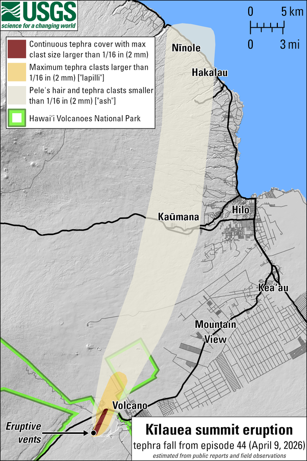
| 44 | April 9, 2026 - 11:10 a.m. | April 9, 2026 - 7:41 p.m. | 8.5 hours | 13 days | 240 | 5.8 | North vent erupted fountain, though most precursory lava flows erupted from the south vent; small eq swarm and deformation on south rim |
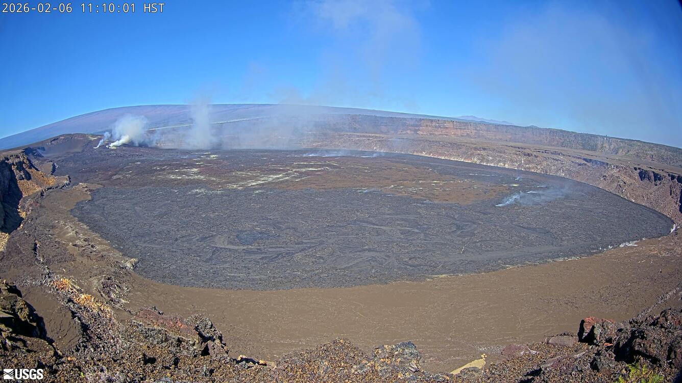
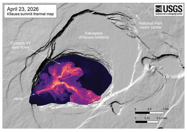
| 45 | April 23, 2026 - 1:34 a.m. | April 23, 2026 - 10:01 a.m. | 8.5 hours | 12 days | 265 | 5.2 | North vent erupted lava fountain; precursory lava flows from both vents |
| 46 | May 5, 2026 - 8:17 a.m. | May 5, 2026 - 5:22 p.m. | 9 hours | 9 days | 200 | 4.6 | North vent erupted lava fountain; precursory lava flows from both vents |
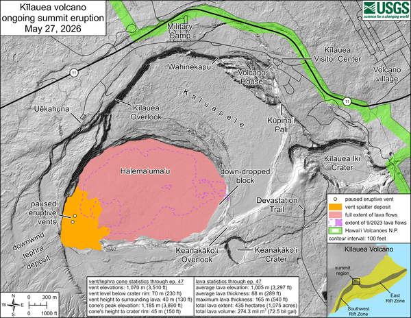
| 47 | May 14, 2026 - 3:27 p.m. | May 15, 2026 - 12:27 a.m. | 9 hours | 17 days | 200 | 5.2 | North vent erupted lava fountain; precursory lava flows exclusively from the south vent. |
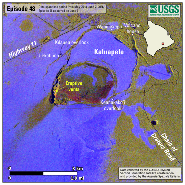
| 48 | June 1, 2026 - 4:40 a.m. | June 1, 2026 - 1:37 p.m. | 9 hours | 13 days | 200 | 5.7 | North vent erupted lava fountain; precursory lava flows exclusively from the south vent. Small eq swarm and deformation on south rim. |
| 49 | June 14, 2026 - 9:36 a.m. | June 14, 2026 - 5:05 p.m. | 7.5 hours | TBD | 210 | 5 | Precursory lava flows from the north and south vents; north vent erupted lava fountain. |