
Map of hydrogen prospectivity for the contiguous United States, identifying regions with favorable conditions for hydrogen accumulation, which includes areas with potential hydrogen sources, porous reservoirs, and effective seals to trap the gas.
Images
Images intro.
Filter Total Items: 75

Geologic Hydrogen web map
Map of hydrogen prospectivity for the contiguous United States, identifying regions with favorable conditions for hydrogen accumulation, which includes areas with potential hydrogen sources, porous reservoirs, and effective seals to trap the gas.
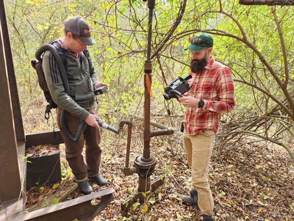
USGS and NETL scientists measuring methane emissions from an orphan well in Hillman State Park, PA
USGS and NETL scientists measuring methane emissions from an orphan well in Hillman State Park, PAUSGS and NETL scientists measuring methane emissions from an orphan well in Hillman State Park, PA. Photo Credit: Karl Haase
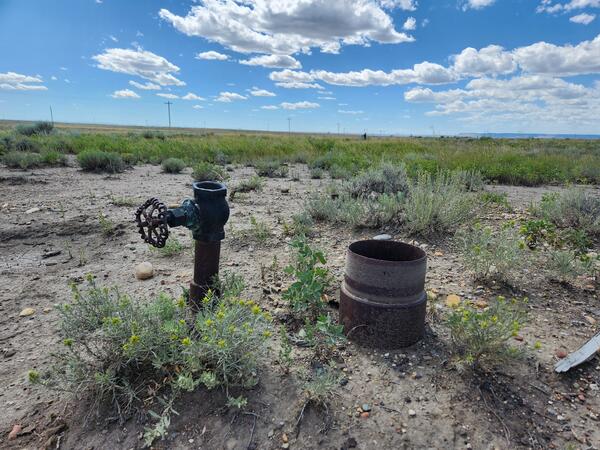
An orphan well sits open and exposed to the environment in Toole County, MT.
An orphan well sits open and exposed to the environment in Toole County, MT.An orphan well sits open and exposed to the environment in Toole County, MT. Photo credit: Nick Gianoutsos
An orphan well sits open and exposed to the environment in Toole County, MT.
An orphan well sits open and exposed to the environment in Toole County, MT.An orphan well sits open and exposed to the environment in Toole County, MT. Photo credit: Nick Gianoutsos
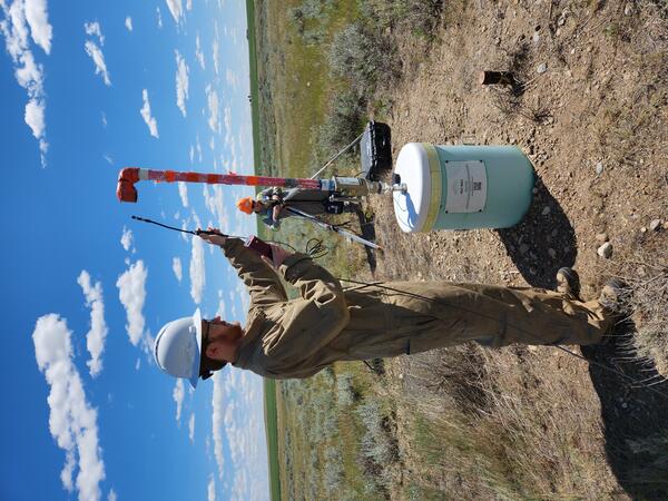
USGS scientist Karl Haase taking a methane reading from an orphan well in Toole County, MT, 1
USGS scientist Karl Haase taking a methane reading from an orphan well in Toole County, MT, 1USGS scientist Karl Haase taking a methane reading from an orphan well in Toole County, MT. Photo Credit: Nick Gianoutsos
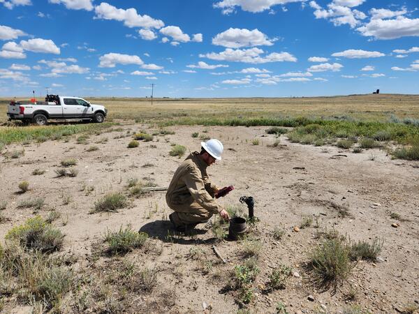
USGS scientist Karl Haase taking a methane reading from an orphan well in Toole County, MT
USGS scientist Karl Haase taking a methane reading from an orphan well in Toole County, MTUSGS scientist Karl Haase taking a methane reading from an orphan well in Toole County, MT. Photo Credit: Nick Gianoutsos

Overview of production test site (June 2023)
The installation of wells, which included two monitoring wells and two production wells, was completed on February 28, 2023, and test operations began on October 24, 2023.
The installation of wells, which included two monitoring wells and two production wells, was completed on February 28, 2023, and test operations began on October 24, 2023.

Uranium resource regions of the United States
Map of Uranium resource regions of the United States. Source: USGS, August 2022
Map of Uranium resource regions of the United States. Source: USGS, August 2022

USGS Geologist Susan Hall studying bleached sandstone near uranium mineralization, Colorado Plateau, UT
USGS Geologist Susan Hall studying bleached sandstone near uranium mineralization, Colorado Plateau, UTUSGS Geologist Susan Hall studying bleached sandstone near uranium mineralizaiton, Colorado Plateau, UT
Source/Usage: Photo by USGS geologist Bradley Van Gosen, Public Domain, Photo taken on 10/1/2021

Uranium mineralized sandstone, Chinle Formation, White Canyon District, Colorado Plateau, UT
Uranium mineralized sandstone, Chinle Formation, White Canyon District, Colorado Plateau, UTUranium mineralized sandstone, Chinle Formation, White Canyon District, Colorado Plateau, UT
Uranium mineralized sandstone, Chinle Formation, White Canyon District, Colorado Plateau, UT
Uranium mineralized sandstone, Chinle Formation, White Canyon District, Colorado Plateau, UTUranium mineralized sandstone, Chinle Formation, White Canyon District, Colorado Plateau, UT

USGS Technicians Prepare to Take a Core of the Austin Chalk in Texas
USGS Technicians Prepare to Take a Core of the Austin Chalk in TexasUSGS technicians at the USGS Gulf Coast #4 Bonham borehole in preparation for geophysical logging of the Austin Chalk Group and the Eagle Ford Group mudstones, Fannin County, Texas.

Austin Chalk Core
Bedding features in the core from the USGS Gulf Coast #4 Bonham borehole, in the Eagle Ford Group mudstones from a depth of about 401 feet, Fannin County, Texas. The Eagle Ford Group lies underneath the Austin Chalk and serves as the source rock for much of the Austin Chalk's petroleum.
Bedding features in the core from the USGS Gulf Coast #4 Bonham borehole, in the Eagle Ford Group mudstones from a depth of about 401 feet, Fannin County, Texas. The Eagle Ford Group lies underneath the Austin Chalk and serves as the source rock for much of the Austin Chalk's petroleum.

GeoChem Access DB Screenshot.JPG
Screenshot of the GeoChem Access Database to use as thumbnail for data object.
Screenshot of the GeoChem Access Database to use as thumbnail for data object.

Uranium deposits in the Jurassic Morrison Formation, Bull Canyon, Coloado
Uranium deposits in the Jurassic Morrison Formation, Bull Canyon, ColoadoUranium deposits in the Jurassic Morrison Formation, Bull Canyon, Colorado. Photographed by Susan Hall, USGS
Uranium deposits in the Jurassic Morrison Formation, Bull Canyon, Coloado
Uranium deposits in the Jurassic Morrison Formation, Bull Canyon, ColoadoUranium deposits in the Jurassic Morrison Formation, Bull Canyon, Colorado. Photographed by Susan Hall, USGS

National Oil and Gas Assessment Provinces
This is a graphic from the USGS National Oil and Gas Assessment Explorer application, which allows user to drill into 70 oil and gas assessment provinces throughout the United States.
This is a graphic from the USGS National Oil and Gas Assessment Explorer application, which allows user to drill into 70 oil and gas assessment provinces throughout the United States.

Vista of Buda, Eagle Ford, and Austin Formations, Terrell County
Vista of Buda, Eagle Ford, and Austin Formations, Terrell CountyOne charge of the U.S. Geological Survey’s Energy Resources Science Center is conducting field work to
better understand the distribution of hydrocarbon source rocks as input to USGS oil and gas
assessments. This 2015 image is a view to the south-southeast of rocks exposed along an unnamed

Going for the Eagle Ford Shale Formation, Kinney County, Texas
Going for the Eagle Ford Shale Formation, Kinney County, TexasOne charge of the U.S. Geological Survey’s Energy Resources Science Center is performing description
and analysis of hydrocarbon source rocks as input to USGS oil and gas assessments. This 2018 image
shows a coring and geophysical well-logging operation adjacent to U.S. Route 90, Kinney County, Texas.

USGS Denver Federal Center Building 25 Entrance
USGS Denver Federal Center Building 25 Entrance
USGS Denver Federal Center Building 25 Entrance

Eagle Ford Test Well Drilling in Texas
USGS researchers drill a research well located on the south side of U.S. 90, 7.1 miles east of Brackettville, Texas. This core was drilled by USGS during field work for an oil and gas assessment for the Eagle Ford of the Gulf Coast Basins. Cores like these provide information on the various rock layers, such as their make-up, their age, etc.
USGS researchers drill a research well located on the south side of U.S. 90, 7.1 miles east of Brackettville, Texas. This core was drilled by USGS during field work for an oil and gas assessment for the Eagle Ford of the Gulf Coast Basins. Cores like these provide information on the various rock layers, such as their make-up, their age, etc.

USGS in South Korea
Tim Collett, USGS research geologist, presenting at the Korean Institute of Geoscience and Mineral Resources' (KIGAM) international program for geoscience resources.
Tim Collett, USGS research geologist, presenting at the Korean Institute of Geoscience and Mineral Resources' (KIGAM) international program for geoscience resources.

Core Storage Facility in Daejeon, South Korea
Core storage facility at the the Korean Institute of Geoscience and Mineral Resources in Daejeon, South Korea
Core storage facility at the the Korean Institute of Geoscience and Mineral Resources in Daejeon, South Korea

Gas Hydrate from offshore Korea
Gas hydrate from offshore Korea courtesy of the Korean Institute of Geoscience and Mineral Resources. Learn more about gas hydrates at https://woodshole.er.usgs.gov/project-pages/hydrates/
Gas hydrate from offshore Korea courtesy of the Korean Institute of Geoscience and Mineral Resources. Learn more about gas hydrates at https://woodshole.er.usgs.gov/project-pages/hydrates/