
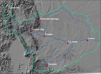
The Arkansas River Basin drains an area of 24,904 square miles of southeastern Colorado. Like other basins on the Front Range, the Arkansas Basin has experienced growth and is expected to have significant increases in growth in the future. Demands on the limited water resources also will increase as changes in water storage, water releases, and/or transfer of waters within or outside of the basin are likely to occur to accommodate the growing population. In addition to changes in water use, water quality within the basin can be affected by land-use changes associated with urbanization and agricultural practices.
In an effort to better understand and minimize potential adverse effects of water- and land-use changes, a number of collaborators including Conservancy Districts, local Water Utility companies and State agencies have identified the need for a common data repository of existing basin data from Federal, State, academia, and local sources.
Targeted constituents to include in the data base are:
- total dissolved solids,
- specific conductance,
- salinity,
- pH,
- water temperature,
- dissolved oxygen,
- sulfate,
- other major ions,
- uranium,
- selenium,
- and nutrients.
Ancillary data sets, such as streamflow information and ground-water levels, and selected GIS (Geographic Information System) digital data sets also need to be compiled and included in a data base.
Below are other science projects associated with the Colorado Water-Quality Data Repository.

Identifying Changes in Background Water-Quality Conditions, Arkansas River and Fountain Creek, Colorado

Upper Yampa Watershed Water-Quality Data

Eagle River Water-Quality Data

Piceance Basin Water-Quality Data

Upper Gunnison River Water-Quality Data

Southwest Study Area Water-Quality Data

Roaring Fork Watershed Water-Quality Data

Blue River Water-Quality Data
The Arkansas River Basin drains an area of 24,904 square miles of southeastern Colorado. Like other basins on the Front Range, the Arkansas Basin has experienced growth and is expected to have significant increases in growth in the future. Demands on the limited water resources also will increase as changes in water storage, water releases, and/or transfer of waters within or outside of the basin are likely to occur to accommodate the growing population. In addition to changes in water use, water quality within the basin can be affected by land-use changes associated with urbanization and agricultural practices.
In an effort to better understand and minimize potential adverse effects of water- and land-use changes, a number of collaborators including Conservancy Districts, local Water Utility companies and State agencies have identified the need for a common data repository of existing basin data from Federal, State, academia, and local sources.
Targeted constituents to include in the data base are:
- total dissolved solids,
- specific conductance,
- salinity,
- pH,
- water temperature,
- dissolved oxygen,
- sulfate,
- other major ions,
- uranium,
- selenium,
- and nutrients.
Ancillary data sets, such as streamflow information and ground-water levels, and selected GIS (Geographic Information System) digital data sets also need to be compiled and included in a data base.
Below are other science projects associated with the Colorado Water-Quality Data Repository.
Identifying Changes in Background Water-Quality Conditions, Arkansas River and Fountain Creek, Colorado
Upper Yampa Watershed Water-Quality Data
Eagle River Water-Quality Data
Piceance Basin Water-Quality Data
Upper Gunnison River Water-Quality Data
Southwest Study Area Water-Quality Data
Roaring Fork Watershed Water-Quality Data