
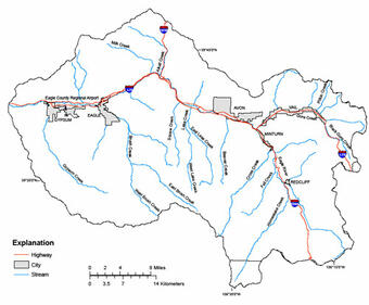
The Eagle River drains approximately 970 square miles (sq mi) west of the Continental Divide in central Colorado before flowing into the Colorado River. The Eagle River watershed (ERW) is located primarily within Eagle County and includes the towns of Vail, Minturn, Avon, Edwards, Eagle, and Gypsum. The eastern boundary of the Eagle River watershed is drained by Gore Creek, located at Vail Pass. Gore Creek flows along I-70 through the town of Vail before its confluence with the main stem Eagle River near the town of Minturn. The Eagle River continues to flow along I-70 to its western boundary near Dotsero.
Increased tourism and development in Eagle County is in part due to the high mountain environment and accessible location within close proximity to the I-70 corridor. As a result, Eagle County has become known as a four-season resort destination. Ski resorts such as Vail and Beaver Creek have brought increased tourism and development to the area.
From the early mining days along the Eagle River to the current tourism based economy, the Eagle River watershed has undergone a sequence of land use changes that has influenced the hydrology, habitat, and water quality of the area. With continued remediation of mine affected areas, expansion of development and tourism, and continued effects related to transportation infrastructure, there are continued and varied demands on water resources within the watershed.
Local entities in the Eagle River watershed who rely on and manage these resources are interested in the assessment of water quantity and water quality to anticipate future management actions to aid in the preservation of the Eagle River watershed.
Water-quality data for the Eagle River watershed have been gathered together so that interested citizens can evaluate historical changes and current quality of stream water and groundwater within the watershed.
OBJECTIVES:
Specific objectives of the study are:
- To characterize existing water-resources and stream-biota data for the Eagle River watershed.
- To analyze historical data and assess the broad-scale geographic and seasonal distribution of current water-quantity and quality and stream-biota conditions in the Eagle River watershed.
- To summarize the current knowledge of the environmental setting and identify, describe, and explain, where possible, the major natural and human factors that affect observed water-quantity and -quality conditions.
- To develop a water-quantity, water-quality, and stream-biota data base.
- To design a water-quality sampling scheme to address water-quality and water-resource management concerns based on results of the retrospective analysis.
- To implement a monitoring program to describe current water-quality, water-quantity, and stream-biota conditions in the Eagle River watershed.
Below are other science projects associated with the Colorado Water-Quality Data Repository.

Upper Yampa Watershed Water-Quality Data

Piceance Basin Water-Quality Data

Upper Gunnison River Water-Quality Data

Southwest Study Area Water-Quality Data

Roaring Fork Watershed Water-Quality Data

Arkansas River Water-Quality Data

Blue River Water-Quality Data
The Eagle River drains approximately 970 square miles (sq mi) west of the Continental Divide in central Colorado before flowing into the Colorado River. The Eagle River watershed (ERW) is located primarily within Eagle County and includes the towns of Vail, Minturn, Avon, Edwards, Eagle, and Gypsum. The eastern boundary of the Eagle River watershed is drained by Gore Creek, located at Vail Pass. Gore Creek flows along I-70 through the town of Vail before its confluence with the main stem Eagle River near the town of Minturn. The Eagle River continues to flow along I-70 to its western boundary near Dotsero.
Increased tourism and development in Eagle County is in part due to the high mountain environment and accessible location within close proximity to the I-70 corridor. As a result, Eagle County has become known as a four-season resort destination. Ski resorts such as Vail and Beaver Creek have brought increased tourism and development to the area.
From the early mining days along the Eagle River to the current tourism based economy, the Eagle River watershed has undergone a sequence of land use changes that has influenced the hydrology, habitat, and water quality of the area. With continued remediation of mine affected areas, expansion of development and tourism, and continued effects related to transportation infrastructure, there are continued and varied demands on water resources within the watershed.
Local entities in the Eagle River watershed who rely on and manage these resources are interested in the assessment of water quantity and water quality to anticipate future management actions to aid in the preservation of the Eagle River watershed.
Water-quality data for the Eagle River watershed have been gathered together so that interested citizens can evaluate historical changes and current quality of stream water and groundwater within the watershed.
OBJECTIVES:
Specific objectives of the study are:
- To characterize existing water-resources and stream-biota data for the Eagle River watershed.
- To analyze historical data and assess the broad-scale geographic and seasonal distribution of current water-quantity and quality and stream-biota conditions in the Eagle River watershed.
- To summarize the current knowledge of the environmental setting and identify, describe, and explain, where possible, the major natural and human factors that affect observed water-quantity and -quality conditions.
- To develop a water-quantity, water-quality, and stream-biota data base.
- To design a water-quality sampling scheme to address water-quality and water-resource management concerns based on results of the retrospective analysis.
- To implement a monitoring program to describe current water-quality, water-quantity, and stream-biota conditions in the Eagle River watershed.
Below are other science projects associated with the Colorado Water-Quality Data Repository.
Upper Yampa Watershed Water-Quality Data
Piceance Basin Water-Quality Data
Upper Gunnison River Water-Quality Data
Southwest Study Area Water-Quality Data
Roaring Fork Watershed Water-Quality Data
Arkansas River Water-Quality Data