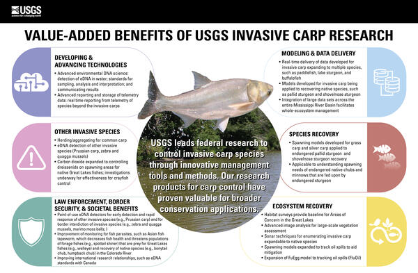
U.S. flag

An official website of the United States government

Images

Images intro.
Filter Total Items: 135
A word cloud representing frequency of words in the PFAS guide
PFAS Word Cloud
PFAS Word Cloud
PFAS Word Cloud

A word cloud representing the frequency of words mentioned in the USGS PFAS Sampling Guide. 

A word cloud representing the frequency of words mentioned in the USGS PFAS Sampling Guide. 

A diagram of PFAS fate and transport
PFAS Fate Transport Diagram

Environmental fate and transport of per- and polyfluoroalkyl substances (PFAS). PFAS can be from direct and indirect releases or emissions of PFAS from producers or industrial facilities manufacturing PFAS (outlined in red). Primary sources (outlined in orange) include consumer goods, PFAS-containing firefighting foams, landfills, and wastewater treatment plants.

Environmental fate and transport of per- and polyfluoroalkyl substances (PFAS). PFAS can be from direct and indirect releases or emissions of PFAS from producers or industrial facilities manufacturing PFAS (outlined in red). Primary sources (outlined in orange) include consumer goods, PFAS-containing firefighting foams, landfills, and wastewater treatment plants.

USGS employees working in a stream
Mussel Restoration Field Work

This is an image of USGS employees working at a field site for a mussel restoration project.

This is an image of USGS employees working at a field site for a mussel restoration project.

Two USGS scientists working in a stream
Restoration Fieldwork

This is a photo of two USGS scientists working in the Clinton Watershed for a Fatmucket mussel reintroduction effort.

This is a photo of two USGS scientists working in the Clinton Watershed for a Fatmucket mussel reintroduction effort.

Mussel silo sitting on the stream bed
Mussel Silo
Mussel Silo
Mussel Silo

This is an image of a mussel silo that has been deployed in the Clinton watershed.

This is an image of a mussel silo that has been deployed in the Clinton watershed.

USGS employee Doug Hardesty holds Fatmucket mussels
Doug Hardesty Holds Mussels

Douglas Hardesty, a USGS employee, holds a handful of juvenile Fatmucket mussels which are intended for reintroduction.

Douglas Hardesty, a USGS employee, holds a handful of juvenile Fatmucket mussels which are intended for reintroduction.

Photo of a mussel silo used in USGS restoration efforts
Mussel Silo
Mussel Silo
Mussel Silo

This is an image of a mussel silo used for CERC-USGS mussel restoration efforts. The mussel silo is a bunker that houses mussels while they grow.

This is an image of a mussel silo used for CERC-USGS mussel restoration efforts. The mussel silo is a bunker that houses mussels while they grow.

Floating Upweller System (FLUPSY) that houses growing mussels
Floating Upweller System (FLUPSY)

Floating Upweller System (FLUPSY) that houses growing mussels intended for reintroduction. This FLUPSY is at the Columbia Environmental Research Center.

Floating Upweller System (FLUPSY) that houses growing mussels intended for reintroduction. This FLUPSY is at the Columbia Environmental Research Center.

Mussels recovered from a silo in October.
Mussels
Mussels
Mussels

Mussels recovered from a silo in October for Columbia Environmental Research Center's mussel restoration project. 

Mussels recovered from a silo in October for Columbia Environmental Research Center's mussel restoration project. 

Person holding mussels
handful of mussels
handful of mussels
handful of mussels

This is a photo of a USGS employee holding a handful of Fatmucket mussels at Columbia Environmental Research Center. These mussels will be used for reintroduction. 

This is a photo of a USGS employee holding a handful of Fatmucket mussels at Columbia Environmental Research Center. These mussels will be used for reintroduction. 

Woman in orange vest, pink hat and camouflage outfit smiles behind hunted deer
NPS biological technician with white-tailed deer

National Park Service Biological Technician Eileen Kramer harvests her first white-tailed deer in New York.

Infographic on Black Carp in the Mississippi River Basin

An infographic highlighting a study finding that black carp, which are an invasive fish species in North America, are now known to be established in the wild in parts of the Mississippi River basin. The infographic was created by the USGS. The USGS was one of the study’s co-authors and the research was led by Southern Illinois University.

An infographic highlighting a study finding that black carp, which are an invasive fish species in North America, are now known to be established in the wild in parts of the Mississippi River basin. The infographic was created by the USGS. The USGS was one of the study’s co-authors and the research was led by Southern Illinois University.

A map of black carp observations in the Mississippi River basin reported to the USGS Nonindigenous Aquatic Species database.
Black Carp Observations in the Mississippi River Basin

A map of black carp observations in the Mississippi River basin reported to the USGS Nonindigenous Aquatic Species database as of November 30, 2022. This map is not a complete representation of species abundance or distribution. These data include incidental captures by the public and reports from federal and state agencies.

A map of black carp observations in the Mississippi River basin reported to the USGS Nonindigenous Aquatic Species database as of November 30, 2022. This map is not a complete representation of species abundance or distribution. These data include incidental captures by the public and reports from federal and state agencies.

Man and child in camouflage smiling for camera with hunted deer in foreground
USGS research biologist and son with white-tailed deer

USGS Research Biologist Nathan Johnson’s son Bryce harvests his first white-tailed deer on private property near High Springs, Florida.

image of CERC Tox Lab
Toxicology Lab at CERC

The Toxicology exposure facilities consists of 23 water baths consisting of small (A) and large (B) baths with proportional diluters capable of delivering at least 6 different concentrations.

The Toxicology exposure facilities consists of 23 water baths consisting of small (A) and large (B) baths with proportional diluters capable of delivering at least 6 different concentrations.

Chart showing the basic overview of the nitrogen cycle
Basic overview of the nitrogen cycle

A basic overview of the nitrogen cycle. Red arrows represent the portions of the nitrogen cycle (decomposition and nitrification) that are performed by our laboratory’s microbial culture.

A basic overview of the nitrogen cycle. Red arrows represent the portions of the nitrogen cycle (decomposition and nitrification) that are performed by our laboratory’s microbial culture.