Photo by USGS scientist William A Link at Erebus Bay, Antarctica. Images were obtained under NMFS Permit No: 1032-1917.

Official websites use .gov
A .gov website belongs to an official government organization in the United States.
Secure .gov websites use HTTPS
A lock () or https:// means you’ve safely connected to the .gov website. Share sensitive information only on official, secure websites.
Eastern Ecological Science Center images.

Photo by USGS scientist William A Link at Erebus Bay, Antarctica. Images were obtained under NMFS Permit No: 1032-1917.
Photo by USGS scientist William A Link at Erebus Bay, Antarctica. Images were obtained under NMFS Permit No: 1032-1917.

Pup playfully greets mother in the snow.
Photo by USGS scientist William A Link at Erebus Bay, Antarctica. Images were obtained under NMFS Permit No: 1032-1917.
Pup playfully greets mother in the snow.
Photo by USGS scientist William A Link at Erebus Bay, Antarctica. Images were obtained under NMFS Permit No: 1032-1917.

Baby seal rests on its side in the snow. Images were obtained under NMFS Permit No: 1032-1917.
Baby seal rests on its side in the snow. Images were obtained under NMFS Permit No: 1032-1917.

Baby seal rests on its side in the snow. Images were obtained under NMFS Permit No: 1032-1917.
Baby seal rests on its side in the snow. Images were obtained under NMFS Permit No: 1032-1917.

Principal investiigator Dr Jay Rotella of Montana State University. Images were obtained under NMFS Permit No: 1032-1917.
Principal investiigator Dr Jay Rotella of Montana State University. Images were obtained under NMFS Permit No: 1032-1917.

Mount Erebus in background. Images were obtained under NMFS Permit No: 1032-1917.
Mount Erebus in background. Images were obtained under NMFS Permit No: 1032-1917.

In Turners Falls Massachusetts at the EESC-USGS Conte Fish Lab we are situated on a power canal pulled from the Connecticut River to supply water to the hydroelectric plant adjacent to our location. This location attracts so many species of birds from Ducks, to Swans, to Canada geese & these beautiful Blue heron & White Egrets.
In Turners Falls Massachusetts at the EESC-USGS Conte Fish Lab we are situated on a power canal pulled from the Connecticut River to supply water to the hydroelectric plant adjacent to our location. This location attracts so many species of birds from Ducks, to Swans, to Canada geese & these beautiful Blue heron & White Egrets.

Picture of a brook trout taken in August 2014 from survey to evaluate potential effect of shale gas development.
Picture of a brook trout taken in August 2014 from survey to evaluate potential effect of shale gas development.

This field staff is measuring campsite conditions in the Boundary Waters Canoe Area Wilderness, MN. The diagram shows measurements taken using the Variable Radial Transect method for computing the area of disturbance within campsite boundaries. Approximately 30 measures of campsite degradation are assessed on each campsite.
This field staff is measuring campsite conditions in the Boundary Waters Canoe Area Wilderness, MN. The diagram shows measurements taken using the Variable Radial Transect method for computing the area of disturbance within campsite boundaries. Approximately 30 measures of campsite degradation are assessed on each campsite.

A plethodontid (lungless) salamander peaks over the top of a collection bucket as it awaited return to its habitat.
A plethodontid (lungless) salamander peaks over the top of a collection bucket as it awaited return to its habitat.

A Palm Warbler during migration at Knowles Marsh on the Patuxent Research Refuge in Laurel, MD
A Palm Warbler during migration at Knowles Marsh on the Patuxent Research Refuge in Laurel, MD

Male and female mallard ducks swimming along at Blackwater National Wildlife Refuge near Cambridge, MD.
Male and female mallard ducks swimming along at Blackwater National Wildlife Refuge near Cambridge, MD.

Red Knots, a migratory shorebird, flying over a salt marsh in coastal Worcester County, Maryland
Red Knots, a migratory shorebird, flying over a salt marsh in coastal Worcester County, Maryland

USGS scientist Vicki Blazer obtaining a blood sample and performing fish necropsy for fish health assessments
USGS scientist Vicki Blazer obtaining a blood sample and performing fish necropsy for fish health assessments

American kestrel used to assess anticoagulant hazard to non-target raptors. Development of a Physiologically-Based Pharmacokinetic Model for Rodenticides Modifications; Toxicity of biologically incorporated chlorophacinone; Sequential Exposures to First and Second Generation Rodenticides by Non-target Raptors
American kestrel used to assess anticoagulant hazard to non-target raptors. Development of a Physiologically-Based Pharmacokinetic Model for Rodenticides Modifications; Toxicity of biologically incorporated chlorophacinone; Sequential Exposures to First and Second Generation Rodenticides by Non-target Raptors

A Lincoln's Sparrow wintering at the Patuxent Research Refuge with the Eastern Ecological Science Center.
A Lincoln's Sparrow wintering at the Patuxent Research Refuge with the Eastern Ecological Science Center.

Pine Warbler foraging on a cold spring day foraging on the ground. Photo courtesy of Mikey Lutmerding, Wildlife Biologist. Photo taken at Point Lookout State Park, Scotland, MD
Pine Warbler foraging on a cold spring day foraging on the ground. Photo courtesy of Mikey Lutmerding, Wildlife Biologist. Photo taken at Point Lookout State Park, Scotland, MD
Pine Warbler foraging on a cold spring day foraging on the ground. Photo courtesy of Mikey Lutmerding, Wildlife Biologist. Photo taken at Point Lookout State Park, Scotland, MD.
Pine Warbler foraging on a cold spring day foraging on the ground. Photo courtesy of Mikey Lutmerding, Wildlife Biologist. Photo taken at Point Lookout State Park, Scotland, MD.
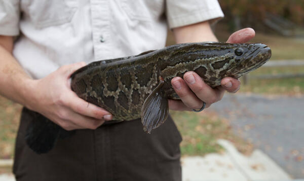
U.S. Fish & Wildlife Service biologist holding a Northern Snakehead (Channa argus) captured in Maryland.
U.S. Fish & Wildlife Service biologist holding a Northern Snakehead (Channa argus) captured in Maryland.

A juvenile Prairie Warbler at a stopover site along the Chesapeake Bay. Photo courtesy of Michael Lutmerding of the EESC
A juvenile Prairie Warbler at a stopover site along the Chesapeake Bay. Photo courtesy of Michael Lutmerding of the EESC

USGS Scientists John Young (L), Jennifer Rapp (Center), and Kelly Maloney (R) take a break from collecting river bottom elevations on the Delaware River with GPS and boat-based sonar for a study investigating bathymetric lidar mapping capabilities.
USGS Scientists John Young (L), Jennifer Rapp (Center), and Kelly Maloney (R) take a break from collecting river bottom elevations on the Delaware River with GPS and boat-based sonar for a study investigating bathymetric lidar mapping capabilities.