

Government officials and scientists had high hopes for Landsat when the first experimental satellite launched July 23, 1972. Those hopes were soon realized when imagery came back depicting features never before seen. Since then, an archive of imagery surpassing 10 million scenes has amassed at EROS, collected from eight different Landsat satellites.
Landsat at Work: Helping Farmers Keep Soil Healthy
Satellite data helps track and reward beneficial growing practices
Satellite data helps track and reward beneficial growing practices
By Earth Resources Observation and Science (EROS) Center
September 15, 2025
For farmers, uncertainty is a constant. Much is beyond their control, and the weather is just one example. What looks like a bumper crop of soybeans one day could be shredded by hail or flooded by a deluge the next.
But farmers can make choices that put the odds in their favor. They can buy crop insurance to help in case of a weather disaster. They can adopt conservation practices that preserve and improve soil health to give crops a better foundation.
Agricultural businesses—such as food manufacturers with an eye to the future—have a vested interest in how farmers who supply crops are growing them. Healthy soils support consistent, quality yields and benefits both farmers and the broader agriculture system. Conservation practices that protect soil health also advance sustainability goals—an overarching approach to fulfilling the world’s food needs using environmentally responsible practices.
Satellites have become a valuable component for many aspects of farming, and they provide land use and land cover information to support conservation methods. The Landsat program, the United States’ globally recognized gold standard satellite for providing scientific quality data, remains one of the vital indicators of landscape change around the world.
Satellite Support for American Agriculture
Satellite Support for American Agriculture
Agriculture is a significant economic driver in the United States. In 2023, 334 million acres were used to grow crops, according to the U.S. Department of Agriculture (USDA). And those crops were sold for a total of \$267.4 billion, before expenses were deducted.
The economic impact of agriculture extends far beyond farmers, however, and not only includes a wide variety of agricultural support services, but also encompasses manufacturing industries, services and retail sales of food, clothing, leather, forestry and fishing. This impact added up to a \$1.537 trillion contribution to the U.S. economy in 2023—5.5% of the nation’s entire gross domestic product.
Tools that make satellite data useful to agricultural businesses are also included. Satellite data can help identify what crops are growing where, when they are planted and harvested, which tillage practices are used, and where cover crops are planted with the intent of benefiting the soil rather than providing a harvest. These insights are used by agricultural researchers, conservation programs and technology companies developing tools to support sustainable farming.
John Shriver is the director of data science at Regrow Ag, a software development company that uses satellite data to help companies in the agriculture business meet their sustainability goals. According to Shriver, companies using Regrow Ag tools have contributed millions of dollars to farmer incentive programs supporting practices like planting cover crops and using reduced-till or no-till methods.
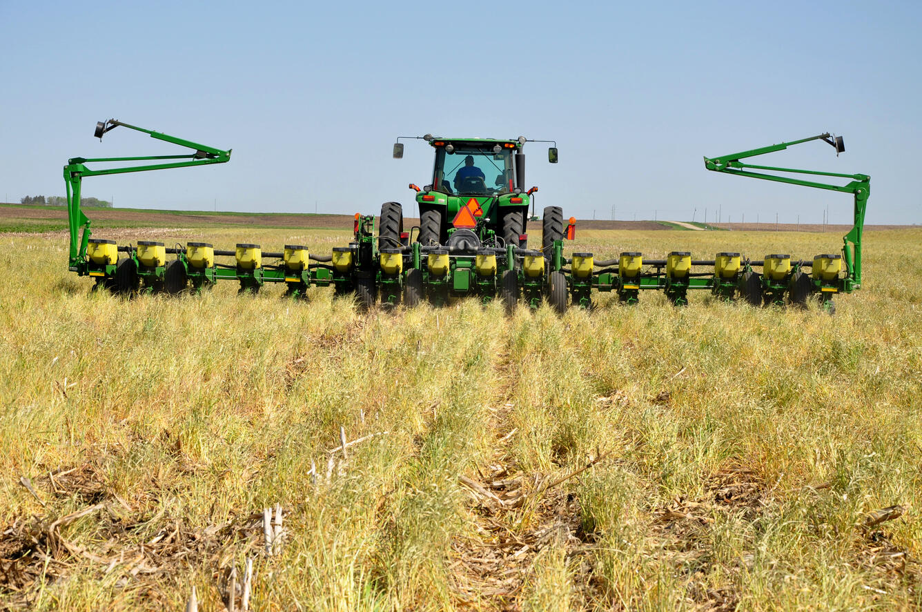
Background photo: A farmer uses a no-till planter to plant soybeans into a cereal rye cover crop that has been killed off recently to avoid interference with the main crop. Photo by Jason Johnson of the U.S. Department of Agriculture’s Natural Resources Conservation Service.
Sources/Usage: Public Domain. View Media Details
Landsat’s Long Record Helps
Landsat’s Long Record Helps
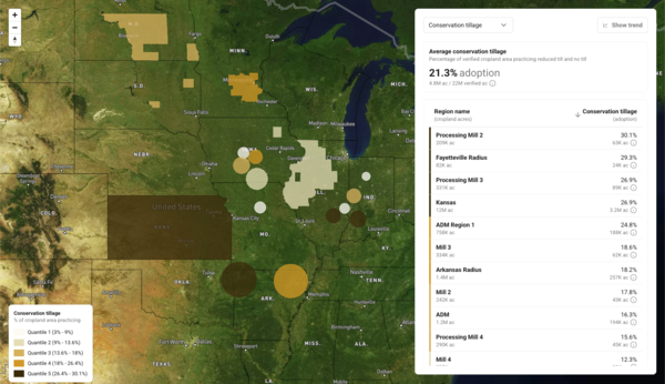
To track practices beneficial to the soil, also called regenerative agriculture, companies start with a baseline look at their crop area of interest and then compare annual changes to that baseline.
Media
Sources/Usage: Some content may have restrictions. View Media Details
Shriver’s team provides a landscape view using a variety of satellite imagery, including Landsat, along with the U.S. Department of Agriculture’s Cropland Data Layer, which also incorporates Landsat data; ground truth surveys; and crop surveys.
“We build out machine learning models to predict, for each year that we’re looking at, what crop was grown, when it was planted and harvested,” Shriver said. Landsat’s spectral bands help them note whether the fields stay green between cash crop growing seasons, indicating a cover crop, or whether a field has been tilled and left bare.
Landsat pioneered Earth observation from space more than 50 years ago and has amassed a robust historical collection of data since.
“One of the things that’s really important for our customers is the ability to do this over a long period of time. Landsat allows us to have this continuous data product that goes all the way back,” Shriver said. A customer posing a question doesn’t have to wait for newly collected data to answer it when an archive of data already exists. They can make decisions and changes right away based on that record.
“Using the Landsat archive as a way to really understand what’s happening on the landscape, and the continuity in terms of the legacy of the actual satellite sensor, then gives us a certain amount of ability to compare apples to apples,” Shriver added. “What’s changing in our data? When is it because we’ve introduced a new sensor, or when is it because there’s been some sort of actual change in the landscape?”
Landsat and Commercial Satellite Imagery
Landsat and Commercial Satellite Imagery
Beyond the value of its decades of continuous satellite imagery, Shriver has also found Landsat helpful with commercial satellite imagery. Landsat is a federal partnership in which NASA builds and launches the satellites, and the U.S. Geological Survey operates them and maintains the open-access data archive. Commercial satellites are typically sent into space by private companies that then charge customers for their data.
Landsat satellites provide a variety of spectral bands—visible, near-infrared, shortwave-infrared and thermal—at a lower resolution than many commercial satellites. Shriver leverages this fact when tackling new questions, first exploring them with no-cost Landsat data before developing a new model with paid commercial data.
Because Landsat satellites undergo rigorous calibration before launch and continually while in orbit, Shriver also uses Landsat to evaluate the accuracy of specific commercial imagery—how well it is calibrated, or how well data from the satellite sensor agrees with corresponding reference plots on the ground.
“Having something like Landsat, where you can treat it as a gold standard to say, ‘How well do these other data providers fit into the landscape, and how do I use their data, referencing against something I know I can trust?’—that's been very valuable for us,” Shriver said.
And Landsat data has been valuable for farmers. It helps reduce their expenses, such as with strategic irrigation management, and adds to their income and the health of their land through incentives offered by agricultural companies.
Agriculture is just one example of the many industries that use Landsat data. For all of its direct uses, Landsat’s total annual value was calculated to be \$25.6 billion in 2023.
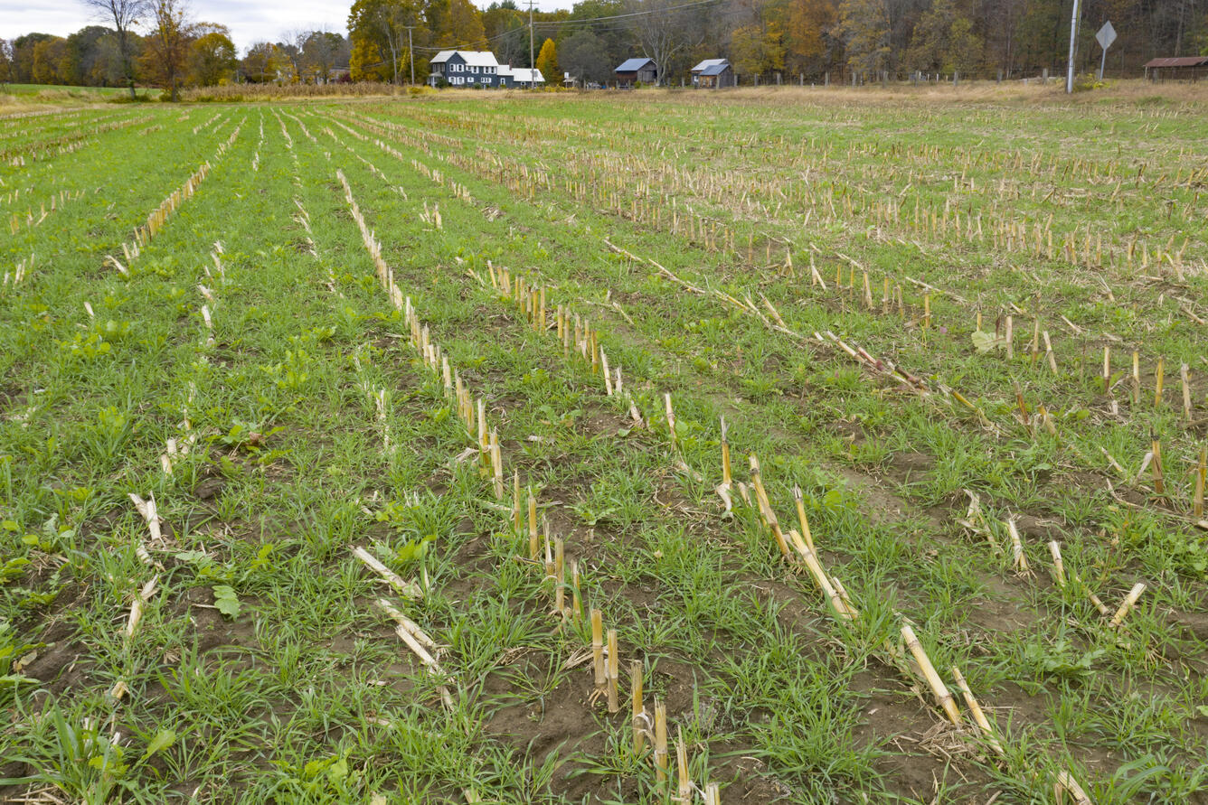
Background photo: A cover crop grows in a harvested cornfield near Deerfield, Massachusetts. U.S. Department of Agriculture public domain photo by Lance Cheung.
Sources/Usage: Public Domain. View Media Details
Note: Landsat data are available from the U.S. Geological Survey at no cost to users.
Disclaimer: The Landsat at Work series highlights how Landsat data are used by multiple industries, including agriculture. The web page contains hypertext links to information created and maintained by other organizations. USGS is not responsible for the content of any off-site pages. Reference herein to any specific commercial products, processes, or services by trade name, trademark, manufacturer, or otherwise, does not constitute or imply its endorsement or recommendation by the United States Government.
More Landsat at Work Examples
More Landsat at Work Examples
-

Landsat at Work: Transforming Data into Solutions Landsat at Work: Transforming Data into Solutions
Landsat’s satellite imagery provides valuable data used by industries and decision makers in the field, ranging from energy and utilities to agriculture, insurance and more. Landsat’s archive reaches back more than 50 years, providing valuable insights into land, water and environmental conditions that shape planning, management, and response.
Related
Learn more about the Landsat Program and how Landsat has been used in agriculture.
Government officials and scientists had high hopes for Landsat when the first experimental satellite launched July 23, 1972. Those hopes were soon realized when imagery came back depicting features never before seen. Since then, an archive of imagery surpassing 10 million scenes has amassed at EROS, collected from eight different Landsat satellites.
")
Landsat: Celebrating 50 Years (Extended Edition)
50 years of teamwork. 50 years of innovation. 50 years of resilience. In 1966, Secretary of the Interior Stewart Udall announced his vision to create a program aimed at gathering facts about the natural resources of the Earth from Earth orbiting satellites. It was a bold proclamation. It was also an idea that worked and continues to work 50 years on.
50 years of teamwork. 50 years of innovation. 50 years of resilience. In 1966, Secretary of the Interior Stewart Udall announced his vision to create a program aimed at gathering facts about the natural resources of the Earth from Earth orbiting satellites. It was a bold proclamation. It was also an idea that worked and continues to work 50 years on.

Eyes on Earth Episode 35 – Watching the Water Supply with OpenET
Eyes on Earth Episode 35 – Watching the Water Supply with OpenETEvapotranspiration is the process by which water transpires from the leaves and stems of plants and evaporates from the Earth’s surface. ET is an important metric for managing water use, but data availability has long been an issue.

Landsat in Action - Water Use with Molly Maupin and Gabriel Senay
Landsat in Action - Water Use with Molly Maupin and Gabriel SenayUSGS Hydrologist Molly Maupin and USGS Research Physical Scientist Gabriel Senay discuss how Landsat imagery has been used by the National Water Census and in studying water use trends.

Landsat in Action - Monitoring Crop Land with Martha Anderson
Landsat in Action - Monitoring Crop Land with Martha AndersonMartha Anderson with the US Department of Agriculture talks about the value of Landsat and its thermal data in studying agricultural land.
Landsat in Action - Monitoring Crop Land with Martha Anderson
Landsat in Action - Monitoring Crop Land with Martha AndersonMartha Anderson with the US Department of Agriculture talks about the value of Landsat and its thermal data in studying agricultural land.
Related
Learn more about the Landsat Program and how Landsat has been used in agriculture.
Eyes on Earth Episode 78 - Landsat 50 Lookback
Government officials and scientists had high hopes for Landsat when the first experimental satellite launched July 23, 1972. Those hopes were soon realized when imagery came back depicting features never before seen. Since then, an archive of imagery surpassing 10 million scenes has amassed at EROS, collected from eight different Landsat satellites.
Government officials and scientists had high hopes for Landsat when the first experimental satellite launched July 23, 1972. Those hopes were soon realized when imagery came back depicting features never before seen. Since then, an archive of imagery surpassing 10 million scenes has amassed at EROS, collected from eight different Landsat satellites.
Landsat: Celebrating 50 Years (Extended Edition)
50 years of teamwork. 50 years of innovation. 50 years of resilience. In 1966, Secretary of the Interior Stewart Udall announced his vision to create a program aimed at gathering facts about the natural resources of the Earth from Earth orbiting satellites. It was a bold proclamation. It was also an idea that worked and continues to work 50 years on.
50 years of teamwork. 50 years of innovation. 50 years of resilience. In 1966, Secretary of the Interior Stewart Udall announced his vision to create a program aimed at gathering facts about the natural resources of the Earth from Earth orbiting satellites. It was a bold proclamation. It was also an idea that worked and continues to work 50 years on.
Eyes on Earth Episode 35 – Watching the Water Supply with OpenET
Eyes on Earth Episode 35 – Watching the Water Supply with OpenETEvapotranspiration is the process by which water transpires from the leaves and stems of plants and evaporates from the Earth’s surface. ET is an important metric for managing water use, but data availability has long been an issue.
Landsat in Action - Water Use with Molly Maupin and Gabriel Senay
Landsat in Action - Water Use with Molly Maupin and Gabriel SenayUSGS Hydrologist Molly Maupin and USGS Research Physical Scientist Gabriel Senay discuss how Landsat imagery has been used by the National Water Census and in studying water use trends.
Landsat in Action - Monitoring Crop Land with Martha Anderson
Landsat in Action - Monitoring Crop Land with Martha AndersonMartha Anderson with the US Department of Agriculture talks about the value of Landsat and its thermal data in studying agricultural land.
Landsat in Action - Monitoring Crop Land with Martha Anderson
Landsat in Action - Monitoring Crop Land with Martha AndersonMartha Anderson with the US Department of Agriculture talks about the value of Landsat and its thermal data in studying agricultural land.