
The Landsat program conceived of in the 1960s, has been running longer than any remote sensing program. The idea was simple: position a satellite in a nearly polar orbit fixed to the solar angle so that each daytime pass would cross the equator at roughly the same local time.
Landsat at Work: Energy Nurturing Nature
Utility company uses Landsat-based NLCD to help identify habitat quality
Utility company uses Landsat-based NLCD to help identify habitat quality
By Earth Resources Observation and Science (EROS) Center
June 16, 2025
The more land managers know about the land they manage, the better decisions they can make. This applies to everyone from farmers and ranchers to timber companies, and even utilities.
Landsat satellite imagery and a variety of tools based on Landsat provide useful information for managing land, especially at a broad scale. One tool, the National Land Cover Database (NLCD), maps land cover consistently across the United States. This makes it easy for organizations to get reliable information they need for multiple states all in one place.
By distinguishing among 16 different land cover types, NLCD is well suited for analyzing complex landscape issues, and the uses of NLCD are vast and varied. For example, in and around cities, NLCD’s labeling of different intensity levels of urban development helps with flood projections. Meanwhile, classifying ecosystems such as forests, wetlands and grasslands indicates the presence of certain wildlife habitats.
Landsat’s annual value was calculated to be \$25.6 billion in 2023, and NLCD’s share of that is notable. But it would be difficult to put a dollar amount on some values related to the land—ecological value, for example.
How would you put a price on the ability to connect two separate habitats with a corridor for wildlife to easily move in between? Or the value of a wetland surrounded by forest or grassland versus a wetland surrounded by parking lots and freeways?
NLCD Is Key Mapping Component
NLCD Is Key Mapping Component
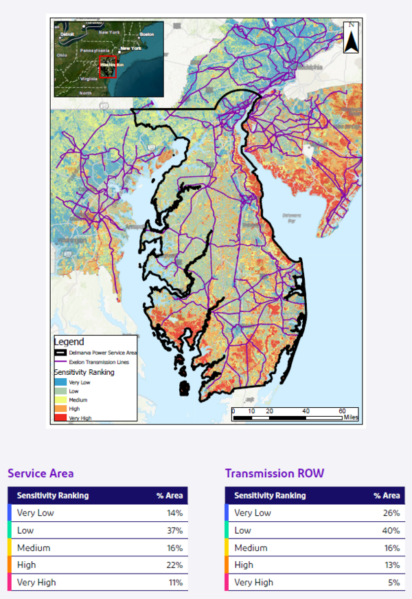
A large U.S. utility company touches a significant amount of land in connection with its electric and natural gas transmission and distribution. That company, Exelon Corporation, sought to better understand the ecological characteristics of its operational lands as part of its broader environmental stewardship goals.
Media
Sources/Usage: Some content may have restrictions. View Media Details
The utility's sustainability team used publicly available information, especially NLCD, to create a baseline set of maps released in 2024 that characterize the level of biodiversity sensitivity, or the diversity of species, for the land in each of its service territories.
Half of the analysis for the maps was weighted to rely on NLCD, and the other half included data on water drainage, protected areas, biodiversity hotspots, average species abundance and water stress, or water demand vs. supply.
NLCD provided the multistate coverage needed at a good resolution, explained Kevin Costello, the senior manager of sustainability strategy. In addition, he said, NLCD “provides a broad representation of the physical and ecological characteristics of the landscapes that we work in and can provide more insight than just specific ecological data.”
Costello used wetlands as an example of why NLCD’s landscape distinctions are important. “While wetlands across our territory are providing ecological services, by layering multiple datasets together, we might be able to conclude that a wetland in an area of higher biological diversity is providing more ecological value than a wetland in an area of lower biological diversity.”
The baseline results ranked most areas of the land its utilities pass through as having low to medium biodiversity sensitivity because of their use as metro areas or agricultural production. However, some areas in the Mid-Atlantic had high biodiversity sensitivity because of the presence of significant coastal and inland wetlands, forests, water stress, biodiversity hotpots and protected areas.
Opportunities to Improve Habitat
With a baseline of ecological value, the company now can make better-informed decisions.
“We’re able to strategically develop stewardship-based projects that could improve ecological quality in our service areas. Exelon performs multiple projects to expand and improve electric and gas service in our territories. While we are performing this work, we look for opportunities to improve the quality of the habitat above the state where we found it. We are leveraging our biodiversity maps to assist in these assessments,” Costello said.
“We’re also looking at things like, where do we have rights-of-way that are in between areas of very high biological quality habitat? Do we have a right-of-way that's connecting existing green spaces, for instance, a state or national park and a nearby land trust? If so, what can we do within that corridor to improve the quality of the habitat so that it helps connect those two ecosystems for the species that may be utilizing our land to migrate between them?”
NLCD and Landsat are tools to help companies consider the bigger picture for land management.
“Landsat can provide a significant value into our analysis on a large-scale assessment of our corporate lands from a stewardship and land management perspective,” Costello said.
This case illustrates how publicly funded Earth observation programs like Landsat and NLCD support informed decision-making across a range of sectors, including energy, agriculture, and conservation.
Note: Landsat data and NLCD data, now called Annual NLCD, are both available from the U.S. Geological Survey at no cost to users.
Disclaimer: This web page contains hypertext links to information created and maintained by other organizations. USGS is not responsible for the content of any off-site pages. Reference herein to any specific commercial products, processes, or services by trade name, trademark, manufacturer, or otherwise, does not constitute or imply its endorsement or recommendation by the United States Government.
More Landsat at Work Examples
More Landsat at Work Examples
-

Landsat at Work: Transforming Data into Solutions Landsat at Work: Transforming Data into Solutions
Landsat’s satellite imagery provides valuable data used by industries and decision makers in the field, ranging from energy and utilities to agriculture, insurance and more. Landsat’s archive reaches back more than 50 years, providing valuable insights into land, water and environmental conditions that shape planning, management, and response.
Related

Annual National Land Cover Database
Land cover is foundational information for land managers, scientists, and the general public. Many types of scientific studies have applied annual land cover information including projecting future land use, documenting forest fragmentation or conservation practices, modeling wildfire hazards, tracking water quality and quantity, and understanding change in wildlife habitat and ecosystem...

Landsat: Celebrating 50 Years
The Landsat program conceived of in the 1960s, has been running longer than any remote sensing program. The idea was simple: position a satellite in a nearly polar orbit fixed to the solar angle so that each daytime pass would cross the equator at roughly the same local time.

Landsat in Action - Land Cover and Land Cover Change with Tom Loveland
Landsat in Action - Land Cover and Land Cover Change with Tom LovelandTom Loveland talks about using Landsat's data for land use and land cover change research.
Find this video and thousands more at https://usgs.gov/gallery.
Landsat in Action - Land Cover and Land Cover Change with Tom Loveland
Landsat in Action - Land Cover and Land Cover Change with Tom LovelandTom Loveland talks about using Landsat's data for land use and land cover change research.
Find this video and thousands more at https://usgs.gov/gallery.
Annual NLCD Collection 1.2 Now Available Annual NLCD Collection 1.2 Now Available
The U.S. Geological Survey (USGS) is excited to announce the release of the Annual National Land Cover Database (NLCD) Conterminous U.S. (CU), Collection 1.2. This release builds on the popular Annual NLCD CU Collection 1.0 by extending the dataset through 2025.
Related
Annual National Land Cover Database
Land cover is foundational information for land managers, scientists, and the general public. Many types of scientific studies have applied annual land cover information including projecting future land use, documenting forest fragmentation or conservation practices, modeling wildfire hazards, tracking water quality and quantity, and understanding change in wildlife habitat and ecosystem...
Landsat: Celebrating 50 Years
The Landsat program conceived of in the 1960s, has been running longer than any remote sensing program. The idea was simple: position a satellite in a nearly polar orbit fixed to the solar angle so that each daytime pass would cross the equator at roughly the same local time.
The Landsat program conceived of in the 1960s, has been running longer than any remote sensing program. The idea was simple: position a satellite in a nearly polar orbit fixed to the solar angle so that each daytime pass would cross the equator at roughly the same local time.
Landsat in Action - Land Cover and Land Cover Change with Tom Loveland
Landsat in Action - Land Cover and Land Cover Change with Tom LovelandTom Loveland talks about using Landsat's data for land use and land cover change research.
Find this video and thousands more at https://usgs.gov/gallery.
Landsat in Action - Land Cover and Land Cover Change with Tom Loveland
Landsat in Action - Land Cover and Land Cover Change with Tom LovelandTom Loveland talks about using Landsat's data for land use and land cover change research.
Find this video and thousands more at https://usgs.gov/gallery.
Annual NLCD Collection 1.2 Now Available Annual NLCD Collection 1.2 Now Available
The U.S. Geological Survey (USGS) is excited to announce the release of the Annual National Land Cover Database (NLCD) Conterminous U.S. (CU), Collection 1.2. This release builds on the popular Annual NLCD CU Collection 1.0 by extending the dataset through 2025.