
Wetland Landscape Characterization
Wetlands purify and store our water, process carbon and nutrients and serve a crucial role in the life cycle of a wide range of flora and fauna. Wetland disturbance from urban development or agriculture can alter the natural flow of runoff and increase the risk for flooding.
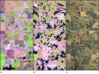
Most scientific products created with an eye to understanding these biological hotspots offer only a glimpse of wetland conditions – historical snapshots in time that represent static conditions in dynamic systems.
At the Earth Resources Observation and Science (EROS) Center, the study of wetlands is focused on a landscape scale over long periods of time. Researchers leverage decades of Landsat satellite data to monitor and quantify the impact of weather, climate and land use on vegetation condition and water resources.
The goal is to offer products that include or enable the evaluation of spatial relationships between and among wetlands and landscape features, and to understand how changes to the land influence hydrology. The baseline born of 30 years of remotely-sensed data compliments existing wetland classifications and offers an opportunity to map, monitor and project long-term change.
The work produced by the Wetland Landscape Characterization project at EROS informs and is informed by the Land Change Monitoring, Assessment and Projection program, an innovative approach to land change study that uses Landsat Analysis Ready Data to characterize historical and near real time land change at any location across the Landsat record, dating back to the 1980s.
Below are other science projects associated with this project.

Inland Lakes, Rivers and Streams
Wetlands purify and store our water, process carbon and nutrients and serve a crucial role in the life cycle of a wide range of flora and fauna. Wetland disturbance from urban development or agriculture can alter the natural flow of runoff and increase the risk for flooding.
Most scientific products created with an eye to understanding these biological hotspots offer only a glimpse of wetland conditions – historical snapshots in time that represent static conditions in dynamic systems.
At the Earth Resources Observation and Science (EROS) Center, the study of wetlands is focused on a landscape scale over long periods of time. Researchers leverage decades of Landsat satellite data to monitor and quantify the impact of weather, climate and land use on vegetation condition and water resources.
The goal is to offer products that include or enable the evaluation of spatial relationships between and among wetlands and landscape features, and to understand how changes to the land influence hydrology. The baseline born of 30 years of remotely-sensed data compliments existing wetland classifications and offers an opportunity to map, monitor and project long-term change.
The work produced by the Wetland Landscape Characterization project at EROS informs and is informed by the Land Change Monitoring, Assessment and Projection program, an innovative approach to land change study that uses Landsat Analysis Ready Data to characterize historical and near real time land change at any location across the Landsat record, dating back to the 1980s.
Below are other science projects associated with this project.