
Web application development to support decision making and deliver actionable science
FORT web applications support management decisions in the Department of the Interior (DOI) related to management of public lands, invasive species, outdoor recreation, and fish and wildlife health.
These applications are developed in partnership with resource managers from Federal, State, local, and Tribal governments, industry, and nongovernmental organizations, empowering local and rural communities to make decisions for themselves using high-quality data and smart tools.
Explore our web applications by topic
Applications for Land Management
Applications for wildlife health and monitoring
Permitting Portal
Funded by the Federal Permitting Improvement Council, FORT scientists are implementing technology to streamline environmental reviews and improve timeliness and transparency of decision-making for federal and non-federal users. Informed by structured user interviews and institutional expertise, the portal incorporates essential functionality to support effective environmental reviews. It will accelerate progress and improve consistency in federal decision-making by:
- Easing discovery and access to tools, data, and science relevant to environmental reviews.
- Enabling users to tailor their experience by specifying management actions and selecting relevant environmental data to characterize resources at a prospective project site and evaluate interactions with surrounding natural resource assets.
- Automating analytics and computation to support reviews at all scales—from individual projects to broad programmatic assessments.
- Accelerating data integration by converting inputs into machine-readable, accessible formats with built-in quality assurance and security screening.
- Aggregating data and information products from diverse sources to support, justify, and streamline decision-making.
- Enabling automated, standardized report generation to reduce workload for both proponents and reviewers.
Surface Disturbance and Reclamation Tracking Tool (SDARTT)
The Surface Disturbance and Reclamation Tracking Tool (SDARTT) is an interactive map tool used to document and track disturbance and reclamation efforts associated with surface activity requiring a Bureau of Land Management (BLM) permit. SDARTT is custom built to increase “efficiency in the Bureau of Land Management's adjudication of applications for permits to drill.” SDARTT is the primary tool used by BLM, proponents, permittees and the general public to track disturbance on BLM lands resulting from BLM permit actions. These data are critical to BLM’s public land use permitting process allowing for coordination across BLM offices on the 19 disturbance threats tracked. BLM relies on SDARTT to ensure compliance with regulations requiring disturbance monitoring.
Mined Lands: Decision Support Tool
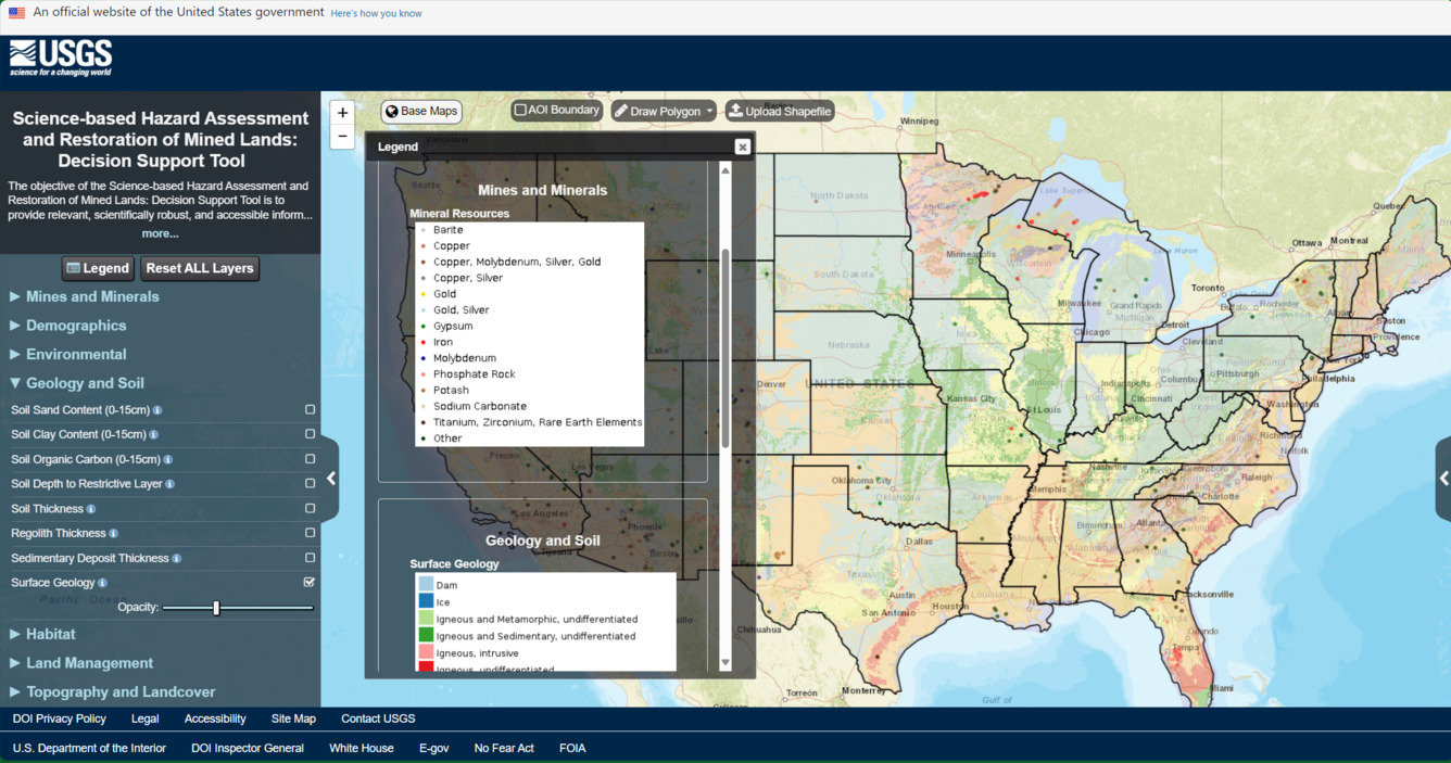
The objective of the Science-based Hazard Assessment and Restoration of Mined Lands: Decision Support Tool is to provide relevant, scientifically robust, and accessible information to support assessment and management of mined lands. This interactive, customizable web map allows users to visualize geospatial data to support the assessment and management of mine lands. Within the mapping tool, users can overlay mine lands and mine-related features with a variety of other landscape characteristics, such as geology or fire history. Users can also generate custom data summaries for user-defined areas of interest. In its initial version, the application gives users a quick summary of summary of mine features. Additional data and capabilities will be added to the tool in future releases.
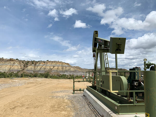
Smart Energy Development
The objective of the Smart Energy Development web tools is to provide relevant, scientifically robust, and accessible information to support energy development and management decisions. By providing a public facing portal, Smart Energy allows all interested parties to access the same, definitive, and current spatial data, thereby facilitating informed decision making. The Smart Energy web tools aggregate a variety of biophysical data layers relevant to energy development, including information on:
- Energy Resources
- Environmental Resources
- Surface Land Management and Ownership
- Land Treatment and Fire History
- Soils and Topography
- Climate and Weather
- Transportation
- Landcover and Vegetation
- Recreation and Visual Resources
Smart Energy analysis tools allow user to select and explore data layers, define a specific area of interest, and generate a summary report of data layers in their area of interest.
The Invasive Species Habitat Tool (INHABIT)


The Invasive Species Habitat Tool (INHABIT) is a web application that reports habitat suitability – the likelihood a plant will grow in a certain area – for over 250 invasive plants in the United States. FORT scientists have partnered closely with invasive species managers to develop this tool, which can facilitate predictions of where invasive plants are likely to invade next for over 10,000 management areas. Using INHABIT, managers can develop species watchlists, identify nearby invasives, and map suitability measures across their region, all to help prevent invasion of noxious weeds across the United States.
North American Bat Monitoring Program (NABat)
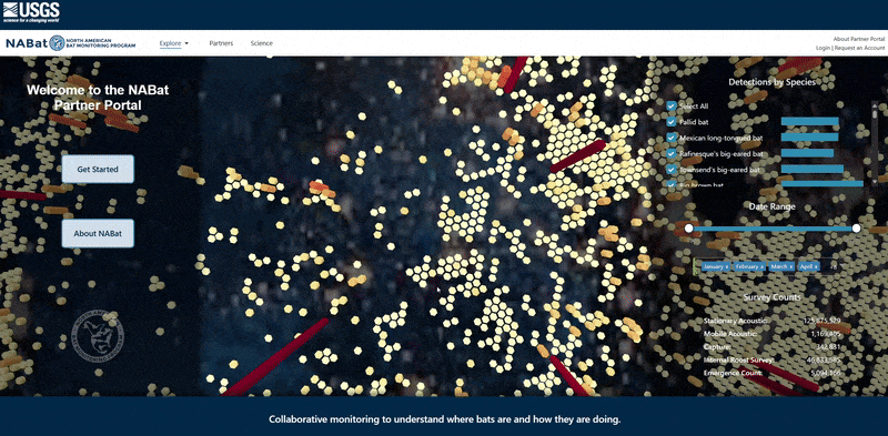
NABat was established in 2015 as a multi-national, multi-agency coordinated bat population monitoring program. NABat was designed to unify and enable a dispersed community to practicably monitor an entire continent at repeated intervals, assemble data from individual efforts in a centralized database and deliver status and trends for one of North America’s critical resources – bats. Now, ten years in, NABat serves as the information system for 47 North American bat species, supporting informed decision-making through robust data collection, data management, and analysis
The NABat Partner Portal serves as the interface between NABat partners and the NABat database, enabling users to upload, archive, and access their own data or request data from other NABat partners. The Partner Portal also features a variety of web-based tools to assist users in project planning and mapping. In 2025, NABat contains records from stationary acoustic surveys, mobile acoustic surveys, capture surveys, internal roost counts, and emergence counts from over 480 different partner organizations and 2400 users. As policy and partner needs evolve, the NABat database will as well.
DOI Bison Metapopulation Dashboard
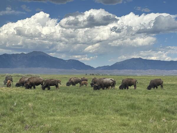
The Bison Metapopulation Strategy establishes a science-based framework for a nationally coordinated strategy for bison managed by the DOI, to support the genetic conservation goals outlined in the 2020 BCI. It is a decision-making framework that guides managers through the process of determining when and how to consider bison translocations, while also considering cattle introgression and bison health.
The USGS-hosted DOI Bison Metapopulation Dashboard supports DOI agencies in their implementation of the Metapopulation Strategy. This comprehensive database, data visualization, and analysis tool stores individual- and herd-level bison data, including information on demographics, measures of genetic diversity, cattle introgression, translocation history, and the status of known federally regulated diseases in each herd. These data can support analyses that help inform when, how many, and where bison could be moved to maximize levels of genetic diversity within herds and across the metapopulation.
Chronic Wasting Disease Strain and Genetic Online Tissue Repository
The Chronic Wasting Disease Strain and Genetic Online Tissue Repository is a virtual repository of tissue and reagents for chronic wasting disease (CWD), accessible by researchers worldwide to request samples in furtherance of study objectives. Metadata collected by the repository may be used to better predict the potential spread of CWD, allowing for focused surveillance and mitigation resources, and assist in identification of novel emerging strains.
PopEquus
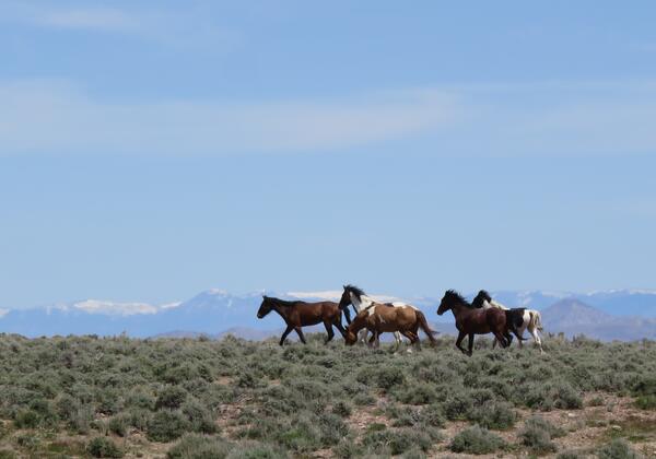
PopEquus is a predictive population modeling tool to support management decisions for free-roaming horse populations. The application simulates how different management actions influence the size of horse populations, while measuring metrics related to the amount of management performed and management costs. Users can specify features of a horse population and select from among six management actions to be applied to the population, either alone or in combination with other actions. The model then projects how population size might be expected to change through time, given the selected management alternatives, and useful metrics describing the results are summarized in figures and tables. In general, PopEquus provides natural resource managers a decision-support tool to estimate trade-offs among management alternatives, so that they might be able to identify effective management solutions for populations.
Greater Sage-Grouse Population Monitoring Framework

Greater sage-grouse populations fluctuate every 6 to 12 years due to cyclic environmental conditions affecting food and habitat availability. These fluctuations challenge wildlife managers in assessing population viability, and can make it difficult for managers to determine how proposed management actions might impact sage-grouse populations. To address this, USGS researchers developed a population monitoring framework with partners, encompassing multiple spatial and temporal scales. Annual state observation data since the 1950s informs the framework, providing numerous population performance measurements for management decisions.
Researchers also created a web-based decision support tool for partners with interactive maps, figures, and tables of annual results, directly incorporable into management plans. Each year, state and federal agencies pool resources to update sage-grouse population trends and the annual warning system led by USGS, involving rigorous reviews and improvements to data and models. Altogether, these tools help federal and state agencies evaluate sage-grouse population changes, informing the management of sagebrush ecosystems affecting sage-grouse populations and directly informing land-use planning efforts.
Boreal Toad Dashboard

FORT researchers, in collaboration with Conservation Science Partners, Inc., developed a decision support framework for managing amphibians in an uncertain future. They used boreal toads, a relatively data rich species, as a case study to develop an occupancy model that incorporates multiple threats, including disease and changes in hydrology. The associated web tool provides information on the probabilities of occupancy, colonization, and extinction under current and future environmental conditions for both boreal toads and the amphibian chytrid fungus at multiple spatial scales. It also includes spatial information on current fire risk, and changes in hydrological patterns at the watershed level over the last thirty years.
Central Flyway Goose Harvest Database
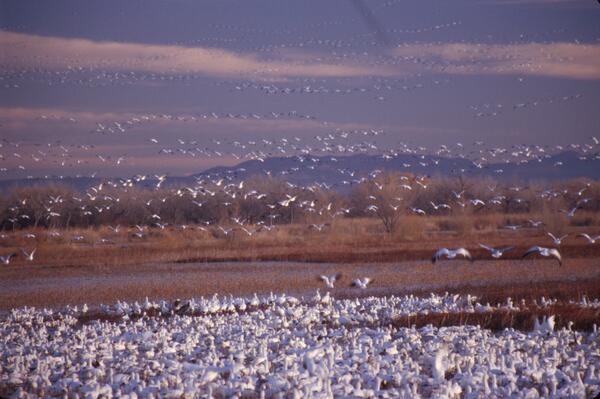
The Central Flyway Goose Harvest Database is a collaboration between USGS, State Agencies representing the Central Flyway Council, the Arctic Goose Joint Venture, and the U.S. Fish and Wildlife Service to gather goose harvest information from hunters for use in estimating goose harvest and abundance data.

North American Bat Monitoring Program (NABat)

Research to support conservation of America’s national mammal, the bison

Values Mapping for Planning in Regional Ecosystems (VaMPIRE)

Counting America’s Wild Horses and Burros: Better Estimates for Population Management

INHABIT: A web tool for invasive plant management across the contiguous United States

Siren: The National Early Detection and Rapid Response Information System

Smart Energy Development: Tools for Informed Development & Successful Reclamation

Surface Disturbance and Reclamation Tracking Tool (SDARTT)
FORT web applications support management decisions in the Department of the Interior (DOI) related to management of public lands, invasive species, outdoor recreation, and fish and wildlife health.
These applications are developed in partnership with resource managers from Federal, State, local, and Tribal governments, industry, and nongovernmental organizations, empowering local and rural communities to make decisions for themselves using high-quality data and smart tools.
Explore our web applications by topic
Applications for Land Management
Applications for wildlife health and monitoring
Permitting Portal
Funded by the Federal Permitting Improvement Council, FORT scientists are implementing technology to streamline environmental reviews and improve timeliness and transparency of decision-making for federal and non-federal users. Informed by structured user interviews and institutional expertise, the portal incorporates essential functionality to support effective environmental reviews. It will accelerate progress and improve consistency in federal decision-making by:
- Easing discovery and access to tools, data, and science relevant to environmental reviews.
- Enabling users to tailor their experience by specifying management actions and selecting relevant environmental data to characterize resources at a prospective project site and evaluate interactions with surrounding natural resource assets.
- Automating analytics and computation to support reviews at all scales—from individual projects to broad programmatic assessments.
- Accelerating data integration by converting inputs into machine-readable, accessible formats with built-in quality assurance and security screening.
- Aggregating data and information products from diverse sources to support, justify, and streamline decision-making.
- Enabling automated, standardized report generation to reduce workload for both proponents and reviewers.
Surface Disturbance and Reclamation Tracking Tool (SDARTT)
The Surface Disturbance and Reclamation Tracking Tool (SDARTT) is an interactive map tool used to document and track disturbance and reclamation efforts associated with surface activity requiring a Bureau of Land Management (BLM) permit. SDARTT is custom built to increase “efficiency in the Bureau of Land Management's adjudication of applications for permits to drill.” SDARTT is the primary tool used by BLM, proponents, permittees and the general public to track disturbance on BLM lands resulting from BLM permit actions. These data are critical to BLM’s public land use permitting process allowing for coordination across BLM offices on the 19 disturbance threats tracked. BLM relies on SDARTT to ensure compliance with regulations requiring disturbance monitoring.
Mined Lands: Decision Support Tool
The objective of the Science-based Hazard Assessment and Restoration of Mined Lands: Decision Support Tool is to provide relevant, scientifically robust, and accessible information to support assessment and management of mined lands. This interactive, customizable web map allows users to visualize geospatial data to support the assessment and management of mine lands. Within the mapping tool, users can overlay mine lands and mine-related features with a variety of other landscape characteristics, such as geology or fire history. Users can also generate custom data summaries for user-defined areas of interest. In its initial version, the application gives users a quick summary of summary of mine features. Additional data and capabilities will be added to the tool in future releases.
Smart Energy Development
The objective of the Smart Energy Development web tools is to provide relevant, scientifically robust, and accessible information to support energy development and management decisions. By providing a public facing portal, Smart Energy allows all interested parties to access the same, definitive, and current spatial data, thereby facilitating informed decision making. The Smart Energy web tools aggregate a variety of biophysical data layers relevant to energy development, including information on:
- Energy Resources
- Environmental Resources
- Surface Land Management and Ownership
- Land Treatment and Fire History
- Soils and Topography
- Climate and Weather
- Transportation
- Landcover and Vegetation
- Recreation and Visual Resources
Smart Energy analysis tools allow user to select and explore data layers, define a specific area of interest, and generate a summary report of data layers in their area of interest.
The Invasive Species Habitat Tool (INHABIT)
The Invasive Species Habitat Tool (INHABIT) is a web application that reports habitat suitability – the likelihood a plant will grow in a certain area – for over 250 invasive plants in the United States. FORT scientists have partnered closely with invasive species managers to develop this tool, which can facilitate predictions of where invasive plants are likely to invade next for over 10,000 management areas. Using INHABIT, managers can develop species watchlists, identify nearby invasives, and map suitability measures across their region, all to help prevent invasion of noxious weeds across the United States.
North American Bat Monitoring Program (NABat)
NABat was established in 2015 as a multi-national, multi-agency coordinated bat population monitoring program. NABat was designed to unify and enable a dispersed community to practicably monitor an entire continent at repeated intervals, assemble data from individual efforts in a centralized database and deliver status and trends for one of North America’s critical resources – bats. Now, ten years in, NABat serves as the information system for 47 North American bat species, supporting informed decision-making through robust data collection, data management, and analysis
The NABat Partner Portal serves as the interface between NABat partners and the NABat database, enabling users to upload, archive, and access their own data or request data from other NABat partners. The Partner Portal also features a variety of web-based tools to assist users in project planning and mapping. In 2025, NABat contains records from stationary acoustic surveys, mobile acoustic surveys, capture surveys, internal roost counts, and emergence counts from over 480 different partner organizations and 2400 users. As policy and partner needs evolve, the NABat database will as well.
DOI Bison Metapopulation Dashboard
The Bison Metapopulation Strategy establishes a science-based framework for a nationally coordinated strategy for bison managed by the DOI, to support the genetic conservation goals outlined in the 2020 BCI. It is a decision-making framework that guides managers through the process of determining when and how to consider bison translocations, while also considering cattle introgression and bison health.
The USGS-hosted DOI Bison Metapopulation Dashboard supports DOI agencies in their implementation of the Metapopulation Strategy. This comprehensive database, data visualization, and analysis tool stores individual- and herd-level bison data, including information on demographics, measures of genetic diversity, cattle introgression, translocation history, and the status of known federally regulated diseases in each herd. These data can support analyses that help inform when, how many, and where bison could be moved to maximize levels of genetic diversity within herds and across the metapopulation.
Chronic Wasting Disease Strain and Genetic Online Tissue Repository
The Chronic Wasting Disease Strain and Genetic Online Tissue Repository is a virtual repository of tissue and reagents for chronic wasting disease (CWD), accessible by researchers worldwide to request samples in furtherance of study objectives. Metadata collected by the repository may be used to better predict the potential spread of CWD, allowing for focused surveillance and mitigation resources, and assist in identification of novel emerging strains.
PopEquus
PopEquus is a predictive population modeling tool to support management decisions for free-roaming horse populations. The application simulates how different management actions influence the size of horse populations, while measuring metrics related to the amount of management performed and management costs. Users can specify features of a horse population and select from among six management actions to be applied to the population, either alone or in combination with other actions. The model then projects how population size might be expected to change through time, given the selected management alternatives, and useful metrics describing the results are summarized in figures and tables. In general, PopEquus provides natural resource managers a decision-support tool to estimate trade-offs among management alternatives, so that they might be able to identify effective management solutions for populations.
Greater Sage-Grouse Population Monitoring Framework
Greater sage-grouse populations fluctuate every 6 to 12 years due to cyclic environmental conditions affecting food and habitat availability. These fluctuations challenge wildlife managers in assessing population viability, and can make it difficult for managers to determine how proposed management actions might impact sage-grouse populations. To address this, USGS researchers developed a population monitoring framework with partners, encompassing multiple spatial and temporal scales. Annual state observation data since the 1950s informs the framework, providing numerous population performance measurements for management decisions.
Researchers also created a web-based decision support tool for partners with interactive maps, figures, and tables of annual results, directly incorporable into management plans. Each year, state and federal agencies pool resources to update sage-grouse population trends and the annual warning system led by USGS, involving rigorous reviews and improvements to data and models. Altogether, these tools help federal and state agencies evaluate sage-grouse population changes, informing the management of sagebrush ecosystems affecting sage-grouse populations and directly informing land-use planning efforts.
Boreal Toad Dashboard
FORT researchers, in collaboration with Conservation Science Partners, Inc., developed a decision support framework for managing amphibians in an uncertain future. They used boreal toads, a relatively data rich species, as a case study to develop an occupancy model that incorporates multiple threats, including disease and changes in hydrology. The associated web tool provides information on the probabilities of occupancy, colonization, and extinction under current and future environmental conditions for both boreal toads and the amphibian chytrid fungus at multiple spatial scales. It also includes spatial information on current fire risk, and changes in hydrological patterns at the watershed level over the last thirty years.
Central Flyway Goose Harvest Database
The Central Flyway Goose Harvest Database is a collaboration between USGS, State Agencies representing the Central Flyway Council, the Arctic Goose Joint Venture, and the U.S. Fish and Wildlife Service to gather goose harvest information from hunters for use in estimating goose harvest and abundance data.
North American Bat Monitoring Program (NABat)
Research to support conservation of America’s national mammal, the bison
Values Mapping for Planning in Regional Ecosystems (VaMPIRE)
Counting America’s Wild Horses and Burros: Better Estimates for Population Management
INHABIT: A web tool for invasive plant management across the contiguous United States
Siren: The National Early Detection and Rapid Response Information System
Smart Energy Development: Tools for Informed Development & Successful Reclamation