
Development and Validation of Hyperspectral Imager for Field and Lab Scanning
The Mineral Resources Program has advanced methods of imaging spectroscopy (hyperspectral remote sensing) that are now used routinely by the earth science and remote sensing communities for mineral mapping, soil quality mapping, hazard mitigation, and other terrestrial and planetary applications. The USGS is highly qualified to advance this technology based on its world class expertise in mineral and material spectroscopy and extensive, well-characterized specimen collections.

Science Issue and Relevance
There is increasing demand for mineral mapping applied to identifying and defining deposits and associated hydrothermal systems, delimiting surface expressions of geologic structures that host deposits, and mitigating hazards associated with mineral resource extraction. The Mineral Resources Program has advanced methods of imaging spectroscopy (hyperspectral remote sensing) that are now used routinely by the earth science and remote sensing communities for mineral mapping, soil quality mapping, hazard mitigation, and other terrestrial and planetary applications. The USGS is highly qualified to advance this technology based on its world class expertise in mineral and material spectroscopy and extensive, well-characterized specimen collections (for example, the USGS spectral library). Our laboratories have set standards in the calibration of a wide range of laboratory, field, and imaging spectrometers. This breadth of expertise is critical to accomplishing this objective and provides a comprehensive perspective matched by few research groups.
Methodology to Address the Issue
Our objectives are to:
- Develop a calibrated hyperspectral imaging system to create mineral maps at high spatial resolution, pixel size as small as 24 microns in the laboratory and a few centimeters in the field.
- Demonstrate the capability of the hyperspectral imaging system in laboratory and field deployment to provide year-round scanning for hand samples and drill core sections, and outcrops and mine faces in the field.
Pilot Project - Hyperspectral Remote Sensing Data and a Multi-proxy Investigation for Characterizing Mineral Resources in Alaska

Why did USGS Conduct this study? Alaska is considered one of the premier locations in the world for mineral exploration and for discovery of world-class mineral resources. However, geologic mapping and exploration are hindered by Alaska’s vast size, remoteness, and rugged terrain. Hyperspectral surveying is one method that can be used to rapidly acquire data about the distributions of surficial materials, including different types of bedrock and ground cover. The USGS conducted a pilot project in the state of Alaska, USA, to test the effectiveness of using imaging spectroscopy (hyperspectral remote sensing) to characterize surficial materials, geology, and potential mineral resources for selected areas of interest (AOIs).
What methodology did USGS use? Our research objectives were to:
- Characterize surficial materials, geology, and minerals using imaging spectroscopy (airborne hyperspectral remote sensing) for selected areas of interest.
- Advance the USGS hyperspectral capabilities to identify and map surface minerals in poorly illuminated, steep, and vegetated terrain at higher latitudes.
- Integrate remote sensing data with field geology, geochemical, and geophysical studies to better characterize known deposits and identify prospective ground for additional mineral resources in Alaska.
The goal of the project was to define the geologic footprint of select deposits using imaging spectroscopy, and regionally extrapolate this knowledge to areas not well characterized. It is expected that the synthesis of results from this multi-disciplinary project will enhance our understanding of the regional geology and be used to develop a predictive exploration model for the identification of base and precious metal-bearing deposits in Alaska and similar remote regions of the world.
Airborne Hyperspectral Data Collection and Analysis - An airborne survey to collect hyperspectral remote sensing data covering several areas of interest in Alaska was performed by the USGS during the summer of 2014. The areas of interest included known large tonnage metallic mineral resources and associated broad alteration footprints. Supporting field work including field spectroscopy, geologic field investigations, and mineral mapping, was conducted to aid in the calibration and interpretation of remotely sensed data.
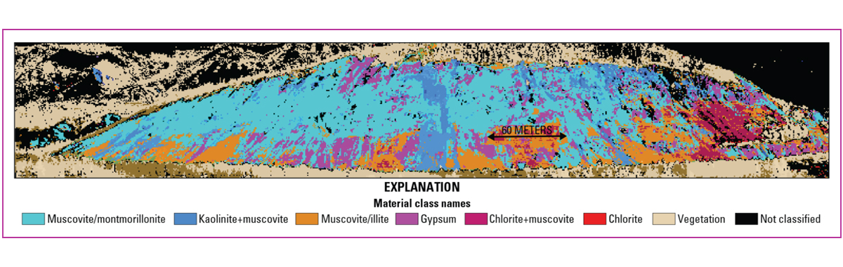
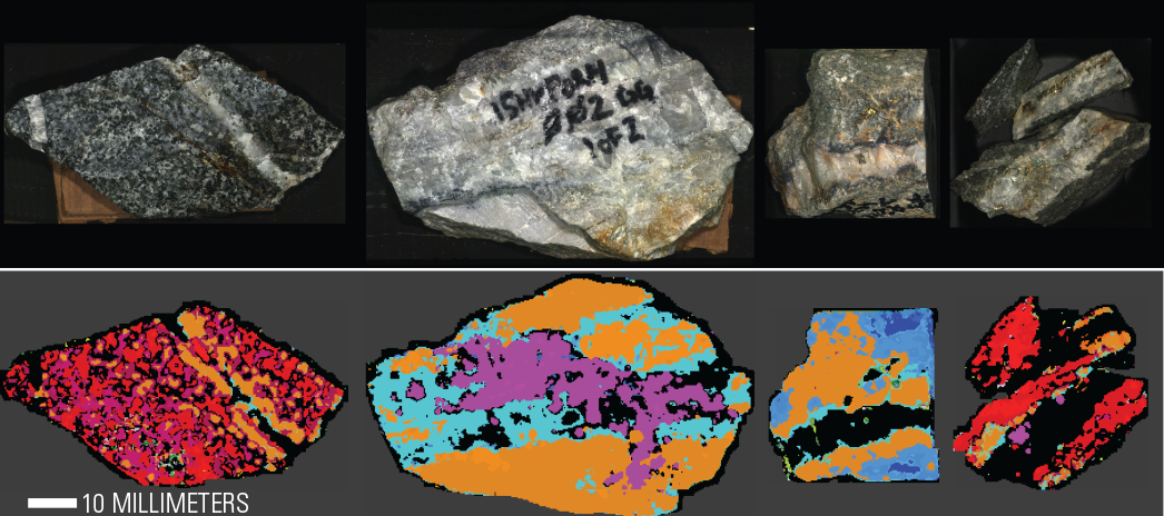
Multi-scale Hyperspectral Data Collection and Synthesis - Hyperspectral data were collected at multiple scales in the Nabesna area of interest. The scales ranged from regional, at 6-meter resolution covering hundreds of kilometers, to outcrop-scale at 30-centimeter resolution, to hand sample scale, at 500-micrometer resolution. This work was conducted in collaboration with the Alaska Department of Natural Resources Division of Geological and Geophysical Surveys, University of Alaska Fairbanks, and National Park Service. Preliminary examination of surface mineral maps show patterns of mineralogy consistent with those predicted from existing geologic maps and descriptions of the porphyry deposits in the region.
Below are other science projects associated with this project.

Spectroscopy and Hyperspectral Imaging of Critical Mineral Resources

USGS High Resolution Spectral Library
The Mineral Resources Program has advanced methods of imaging spectroscopy (hyperspectral remote sensing) that are now used routinely by the earth science and remote sensing communities for mineral mapping, soil quality mapping, hazard mitigation, and other terrestrial and planetary applications. The USGS is highly qualified to advance this technology based on its world class expertise in mineral and material spectroscopy and extensive, well-characterized specimen collections.
Science Issue and Relevance
There is increasing demand for mineral mapping applied to identifying and defining deposits and associated hydrothermal systems, delimiting surface expressions of geologic structures that host deposits, and mitigating hazards associated with mineral resource extraction. The Mineral Resources Program has advanced methods of imaging spectroscopy (hyperspectral remote sensing) that are now used routinely by the earth science and remote sensing communities for mineral mapping, soil quality mapping, hazard mitigation, and other terrestrial and planetary applications. The USGS is highly qualified to advance this technology based on its world class expertise in mineral and material spectroscopy and extensive, well-characterized specimen collections (for example, the USGS spectral library). Our laboratories have set standards in the calibration of a wide range of laboratory, field, and imaging spectrometers. This breadth of expertise is critical to accomplishing this objective and provides a comprehensive perspective matched by few research groups.
Methodology to Address the Issue
Our objectives are to:
- Develop a calibrated hyperspectral imaging system to create mineral maps at high spatial resolution, pixel size as small as 24 microns in the laboratory and a few centimeters in the field.
- Demonstrate the capability of the hyperspectral imaging system in laboratory and field deployment to provide year-round scanning for hand samples and drill core sections, and outcrops and mine faces in the field.
Pilot Project - Hyperspectral Remote Sensing Data and a Multi-proxy Investigation for Characterizing Mineral Resources in Alaska
Why did USGS Conduct this study? Alaska is considered one of the premier locations in the world for mineral exploration and for discovery of world-class mineral resources. However, geologic mapping and exploration are hindered by Alaska’s vast size, remoteness, and rugged terrain. Hyperspectral surveying is one method that can be used to rapidly acquire data about the distributions of surficial materials, including different types of bedrock and ground cover. The USGS conducted a pilot project in the state of Alaska, USA, to test the effectiveness of using imaging spectroscopy (hyperspectral remote sensing) to characterize surficial materials, geology, and potential mineral resources for selected areas of interest (AOIs).
What methodology did USGS use? Our research objectives were to:
- Characterize surficial materials, geology, and minerals using imaging spectroscopy (airborne hyperspectral remote sensing) for selected areas of interest.
- Advance the USGS hyperspectral capabilities to identify and map surface minerals in poorly illuminated, steep, and vegetated terrain at higher latitudes.
- Integrate remote sensing data with field geology, geochemical, and geophysical studies to better characterize known deposits and identify prospective ground for additional mineral resources in Alaska.
The goal of the project was to define the geologic footprint of select deposits using imaging spectroscopy, and regionally extrapolate this knowledge to areas not well characterized. It is expected that the synthesis of results from this multi-disciplinary project will enhance our understanding of the regional geology and be used to develop a predictive exploration model for the identification of base and precious metal-bearing deposits in Alaska and similar remote regions of the world.
Airborne Hyperspectral Data Collection and Analysis - An airborne survey to collect hyperspectral remote sensing data covering several areas of interest in Alaska was performed by the USGS during the summer of 2014. The areas of interest included known large tonnage metallic mineral resources and associated broad alteration footprints. Supporting field work including field spectroscopy, geologic field investigations, and mineral mapping, was conducted to aid in the calibration and interpretation of remotely sensed data.
Multi-scale Hyperspectral Data Collection and Synthesis - Hyperspectral data were collected at multiple scales in the Nabesna area of interest. The scales ranged from regional, at 6-meter resolution covering hundreds of kilometers, to outcrop-scale at 30-centimeter resolution, to hand sample scale, at 500-micrometer resolution. This work was conducted in collaboration with the Alaska Department of Natural Resources Division of Geological and Geophysical Surveys, University of Alaska Fairbanks, and National Park Service. Preliminary examination of surface mineral maps show patterns of mineralogy consistent with those predicted from existing geologic maps and descriptions of the porphyry deposits in the region.
Below are other science projects associated with this project.
Spectroscopy and Hyperspectral Imaging of Critical Mineral Resources