
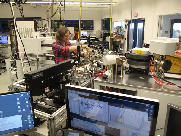
This project supports the USGS argon geochronology laboratory in Denver. The USGS 40Ar/39Ar geochronology laboratory is a state-of-the-art research facility for determining absolute ages of minerals and rocks. The 40Ar/39Ar laboratory contributes critical geochronology to individual USGS research projects and to partners in academia and other Federal agencies. This laboratory develops methodology for small and difficult sample analysis often at the limits of existing mass spectrometer technology.
Science Issue and Relevance
The 40Ar/39Ar Method: 40Ar/39Ar geochronology is an experimentally robust and versatile method for constraining the age and thermal history of rocks. Such information is extremely valuable for understanding a variety of geological processes including the formation of ore deposits, mountain building and history of volcanic events, paleo-seismic events, and paleo-climate. The 40Ar/39Ar isotopic dating method has evolved into the most commonly applied geochronological method, and can be applied to many geological problems that require precise and accurate time and temperature control.
Methodology to Address Issue
This project provides partial support for the USGS argon geochronology laboratory in Denver. The USGS 40Ar/39Ar geochronology laboratory is a state-of-the-art research facility for determining absolute ages of minerals and rocks. The 40Ar/39Ar laboratory contributes critical geochronology to individual USGS research projects and to partners in academia and other Federal agencies. This facility houses necessary equipment for sample preparation and analysis, including high-sensitivity noble gas mass spectrometers and ultraviolet (UV) and infrared (IR) lasers. The versatility of the 40Ar/39Ar method permits determining the timing of processes and events such as igneous intrusions and extrusions, ore mineralization and hydrothermal fluid circulation, metamorphic cooling and exhumation, mineral formation and recrystallization, and shallow crustal faulting. Scientists are dependent on the geochronologist for data and interpretations to determine these parameters. This laboratory develops methodology for small and difficult sample analysis often at the limits of existing mass spectrometer technology.
Below are other science projects associated with this project.
Below are data releases associated with this project. Visit USGS Geochron - a database of geochronologic and thermochronologic dates and data.
40Ar/39Ar geochronology of the Tonopah, Divide, and Goldfield districts, Nevada 40Ar/39Ar geochronology of the Tonopah, Divide, and Goldfield districts, Nevada
Argon geochronology data from the Austroalpine-Pennine boundary, Central Alps, Switzerland Argon geochronology data from the Austroalpine-Pennine boundary, Central Alps, Switzerland
Argon data for: Elemental, isotopic, and geochronological variability in Mogollon-Datil Volcanic Province, New Mexico Argon data for: Elemental, isotopic, and geochronological variability in Mogollon-Datil Volcanic Province, New Mexico
Data release of Geologic Map of the Upper Arkansas River Valley Region, North-Central, Colorado Data release of Geologic Map of the Upper Arkansas River Valley Region, North-Central, Colorado
Argon data for Poncha Pass Geologic Map Argon data for Poncha Pass Geologic Map
40Ar/39Ar data for: Characteristics and 40Ar/39Ar geochronology of the Erdenet Cu-Mo deposit, Mongolia 40Ar/39Ar data for: Characteristics and 40Ar/39Ar geochronology of the Erdenet Cu-Mo deposit, Mongolia
Below are publications associated with this project.
Detrital record of the late Oligocene – Early Miocene mafic volcanic arc in the southern Patagonian Andes (~51 °S) from single-clast geochronology and trace element geochemistry Detrital record of the late Oligocene – Early Miocene mafic volcanic arc in the southern Patagonian Andes (~51 °S) from single-clast geochronology and trace element geochemistry
Dilution and propagation of provenance trends in sand and mud: Geochemistry and detrital zircon geochronology of modern sediment from central California (U.S.A.) Dilution and propagation of provenance trends in sand and mud: Geochemistry and detrital zircon geochronology of modern sediment from central California (U.S.A.)
Multiproxy Cretaceous-Paleogene boundary event stratigraphy: An Umbria-Marche basin-wide perspective Multiproxy Cretaceous-Paleogene boundary event stratigraphy: An Umbria-Marche basin-wide perspective
The influence of foreland structures on hinterland cooling: evaluating the drivers of exhumation in the eastern Bhutan Himalaya The influence of foreland structures on hinterland cooling: evaluating the drivers of exhumation in the eastern Bhutan Himalaya
Petrology of volcanic rocks associated with silver-gold (Ag-Au) epithermal deposits in the Tonopah, Divide, and Goldfield Mining Districts, Nevada Petrology of volcanic rocks associated with silver-gold (Ag-Au) epithermal deposits in the Tonopah, Divide, and Goldfield Mining Districts, Nevada
Petrographic, geochemical, and geochronologic data for cenozoic volcanic rocks of the Tonopah, Divide, and Goldfield Mining Districts, Nevada Petrographic, geochemical, and geochronologic data for cenozoic volcanic rocks of the Tonopah, Divide, and Goldfield Mining Districts, Nevada
Revisiting Herto: New evidence of Homo sapiens from Ethiopia Revisiting Herto: New evidence of Homo sapiens from Ethiopia
A stratigraphic approach to inferring depositional ages from detrital geochronology data A stratigraphic approach to inferring depositional ages from detrital geochronology data
A supervolcano and its sidekicks: A 100 ka eruptive chronology of the Fish Canyon Tuff and associated units of the La Garita magmatic system A supervolcano and its sidekicks: A 100 ka eruptive chronology of the Fish Canyon Tuff and associated units of the La Garita magmatic system
C–O stable isotope geochemistry and 40Ar/39Ar geochronology of the Bear Lodge carbonatite stockwork, Wyoming, USA C–O stable isotope geochemistry and 40Ar/39Ar geochronology of the Bear Lodge carbonatite stockwork, Wyoming, USA
Two-event lode-ore deposition at Butte, USA: 40Ar/39Ar and U-Pb documentation of Ag-Au-polymetallic lodes overprinted by younger stockwork Cu-Mo ores and penecontemporaneous Cu lodes Two-event lode-ore deposition at Butte, USA: 40Ar/39Ar and U-Pb documentation of Ag-Au-polymetallic lodes overprinted by younger stockwork Cu-Mo ores and penecontemporaneous Cu lodes
Establishing chronologies for alluvial-fan sequences with analysis of high-resolution topographic data: San Luis Valley, Colorado, USA Establishing chronologies for alluvial-fan sequences with analysis of high-resolution topographic data: San Luis Valley, Colorado, USA
In addition to the USGS National Cooperative Geologic Mapping Program and the Geosciences and Environmental Change Science Center, below are partners associated with this project.