
Hydrologic technicians Kelly McVicker and Shane Mizelle prepare to collect water samples from the Conowingo Dam.
Images
Explore photos of USGS water science in Maryland, Delaware, and Washington, D.C.
Filter Total Items: 107
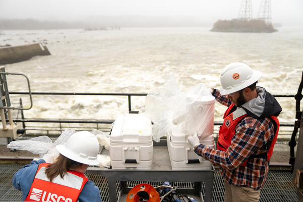
Conowingo Dam Water Quality Sampling
Hydrologic technicians Kelly McVicker and Shane Mizelle prepare to collect water samples from the Conowingo Dam.

Sonde at Conowingo Dam
Hydrologic technician Kelly McVicker examines water-quality readings along the Conowingo Dam as Shane Mizelle lowers the sensor into the waters below.
Spring 2024 Photo Contest Winner: David Fisher, People category
Hydrologic technician Kelly McVicker examines water-quality readings along the Conowingo Dam as Shane Mizelle lowers the sensor into the waters below.
Spring 2024 Photo Contest Winner: David Fisher, People category

Water Quality Sample at Conowingo Dam
Following recent rainfall, hydrologic technician Fisseha Mengistu collected a storm sample from the Susquehanna River at Conowingo, MD (01578310).
Following recent rainfall, hydrologic technician Fisseha Mengistu collected a storm sample from the Susquehanna River at Conowingo, MD (01578310).

Collecting A Water Quality Sample After Tropical Storm Ophelia
Collecting A Water Quality Sample After Tropical Storm OpheliaFollowing rains brought on by Tropical Storm Ophelia (2023), Fisseha Mengistu collects a water-quality sample from Governor's Bridge over the Patuxent River near Bowie.
Collecting A Water Quality Sample After Tropical Storm Ophelia
Collecting A Water Quality Sample After Tropical Storm OpheliaFollowing rains brought on by Tropical Storm Ophelia (2023), Fisseha Mengistu collects a water-quality sample from Governor's Bridge over the Patuxent River near Bowie.

PFAS Analysis in a Field
Nothing beats processing groundwater samples next to a cornfield! Kelly McVicker (pictured) and Nicole King of our water quality team were on the Eastern Shore of Maryland collecting groundwater samples for selected analyses including per- and polyfluoroalkyl substances (PFAS), also known as “forever chemicals.”
Nothing beats processing groundwater samples next to a cornfield! Kelly McVicker (pictured) and Nicole King of our water quality team were on the Eastern Shore of Maryland collecting groundwater samples for selected analyses including per- and polyfluoroalkyl substances (PFAS), also known as “forever chemicals.”

USGS scientists Natalie Hall and Marina Metes install an AI/ML Camera
USGS scientists Natalie Hall and Marina Metes install an AI/ML CameraSmile! USGS scientists Marina Metes (left) and Natalie Hall (right) installed a new time lapse trail camera at Little Seneca Creek to expand the Flow Photo Explorer network.
Images collected by the USGS, our partners, and citizen scientists go to developing an AI model that can predict streamflow from images.

Assessing a Streambank Riparian Zone
USGS physical scientist Zach Clifton assesses a streambank riparian zone in Orson, Pennsylvania.
Photo credit: Neel Hodgkinson/USGS Contractor.
USGS physical scientist Zach Clifton assesses a streambank riparian zone in Orson, Pennsylvania.
Photo credit: Neel Hodgkinson/USGS Contractor.

Crossing a Stream in Orson Pennsylvania
A USGS scientist carries equipment across a stream in Orson, Pennsylvania while conducting a streambank riparian assessment.
Photo credit: David Fisher/USGS Contractor
A USGS scientist carries equipment across a stream in Orson, Pennsylvania while conducting a streambank riparian assessment.
Photo credit: David Fisher/USGS Contractor

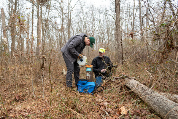
Examining Tree Roots
Physical Scientist Molly Huber of the Florence Bascom Geoscience Center examines tree roots in a location where a root cookie was recently cut.
Molly was there as part of a stream habitat/riparian assessment at Orson Creek in south central Pennsylvania.
Physical Scientist Molly Huber of the Florence Bascom Geoscience Center examines tree roots in a location where a root cookie was recently cut.
Molly was there as part of a stream habitat/riparian assessment at Orson Creek in south central Pennsylvania.

Tyler Bowser Calibrates Rain Gage At Harford Glen
Hydrologic technician Tyler Bowser calibrated our new rain gage at Harford Glen Park. For this weighing-bucket rain gage to report accurate data, it must be calibrated to a standard weight. This gage weighs rainfall and converts the weight to rainfall in inches.
Hydrologic technician Tyler Bowser calibrated our new rain gage at Harford Glen Park. For this weighing-bucket rain gage to report accurate data, it must be calibrated to a standard weight. This gage weighs rainfall and converts the weight to rainfall in inches.

Upstream view from the stream gage on Grave Run near Beckleysville, MD
Upstream view from the stream gage on Grave Run near Beckleysville, MDThis photograph is of the upstream view from the stream gage on Grave Run near Beckleysville, MD. In the photo Logan Tolley, a hydrologic technician at the Baltimore office, is using a Flowtracker 2 to take a discharge measurement.
Spring 2023 Photo Contest Winner: Rustin Pare, Where We Work category

USGS UMBC EPA Partnership Signing Ceremony
From left to right, USGS Northeast Regional Director Mike Tupper, UMBC President Valarie Sheares Ashby, and EPA Chesapeake Bay Program Director Dr. Kandis Boyd hold a signed Memorandum of Understanding between the USGS, UMBC and EPA.
From left to right, USGS Northeast Regional Director Mike Tupper, UMBC President Valarie Sheares Ashby, and EPA Chesapeake Bay Program Director Dr. Kandis Boyd hold a signed Memorandum of Understanding between the USGS, UMBC and EPA.

Servicing The Gage At Anacostia Boat Ramp
Jeremy Malen services the gage at Anacostia River at Anacostia Park Boat Ramp, DC - 01651812.
Jeremy Malen services the gage at Anacostia River at Anacostia Park Boat Ramp, DC - 01651812.

Building a Weighted Bucket Precipitation Gage
Nick Giro holds the top of a weighted bucket instrument as Tyler Bowser walks towards him. At the Rain Gage IN Winters Run Basin Near Bel Air, MD (392913076203601) gage.
Photo by David Fisher/USGS Contractor
Nick Giro holds the top of a weighted bucket instrument as Tyler Bowser walks towards him. At the Rain Gage IN Winters Run Basin Near Bel Air, MD (392913076203601) gage.
Photo by David Fisher/USGS Contractor

Building a Gage at Harford Glen
While building a precipitation gage at Harford Glen Park, hydrologic technician Nick Giro uses a drill while Tyler Bowser digs in the background.
Gage: Rain Gage In Winters Run Basin Near Bel Air, MD - 392913076203601
Photo credit: David Fisher/USGS Contractor
While building a precipitation gage at Harford Glen Park, hydrologic technician Nick Giro uses a drill while Tyler Bowser digs in the background.
Gage: Rain Gage In Winters Run Basin Near Bel Air, MD - 392913076203601
Photo credit: David Fisher/USGS Contractor

Potomac River at Shepherdstown WV Gage
Potomac River at Shepherdstown, West Virginia gage. 01618000
Photo by David Fisher/USGS Contractor
Potomac River at Shepherdstown, West Virginia gage. 01618000
Photo by David Fisher/USGS Contractor

factSheetAustinCover.jpg
Abstract:
Groundwater Measurement in Southern Maryland
Hydrologic technicians Jeff Klein and Chris Cook measure the groundwater level for well CH De 45 (USGS site ID 382927076552301).
Hydrologic technicians Jeff Klein and Chris Cook measure the groundwater level for well CH De 45 (USGS site ID 382927076552301).

A Boat Ride to Ship John Shoal
Hydrologic technician Michael Brownley steers a boat on the Delaware Bay towards Ship John Shoal lighthouse.
Hydrologic technician Michael Brownley steers a boat on the Delaware Bay towards Ship John Shoal lighthouse.

Cleaning a Water Quality Sonde At Ship John Shoal
Samantha Woomer cleans a water quality sonde at Ship John Shoal lighthouse.
Photo credit: David Fisher/USGS Contractor.
Samantha Woomer cleans a water quality sonde at Ship John Shoal lighthouse.
Photo credit: David Fisher/USGS Contractor.

Cleaning a Sonde at Ship John Shoal
Samantha Woomer cleans a water quality sonde with a toothbrush at Ship John Shoal lighthouse.
Photo credit: David Fisher/USGS Contractor
Samantha Woomer cleans a water quality sonde with a toothbrush at Ship John Shoal lighthouse.
Photo credit: David Fisher/USGS Contractor