
Logo in support of the 7th Federal UxS Users Workshop to be hosted March 16-18, 2027
Multimedia
Images

7th Federal UxS Users Workshop
Logo in support of the 7th Federal UxS Users Workshop to be hosted March 16-18, 2027

Attendees of the 6th Federal Uncrewed Systems (UxS) Users Workshop
Attendees of the 6th Federal Uncrewed Systems (UxS) Users WorkshopAerial photo of attendees at the 6th Federal Uncrewed Systems (UxS) Workshop taken from a Skydio drone in front of the Science and Technology building at the Southwestern Indian Polytechnic Institute, Albuquerque, New Mexico.

Saucer Shark Aeroshell and payload suspended by sling
Saucer Shark Aeroshell and payload suspended by slingUSGS National Innovation Center UAS Research Center Saucer Shark Project, before science flight tests, Aeroshell and payload. Sling configuration and payload orientation verified before science flight deployment. Payload is on and ready to record!

BisonCore (MagEdition) displays live magnetic data (top) and lidar altitude (bottom)
BisonCore (MagEdition) displays live magnetic data (top) and lidar altitude (bottom)USGS National Innovation Center UAS Research Center Saucer Shark Project, BisonCore displays the path of the sensor live, as it covers transects. Data received from the payload is then displayed within the BisonCore Ecosystem and is accessible for field viewing. The magnetic map is also used to validate payload directed algorithms.
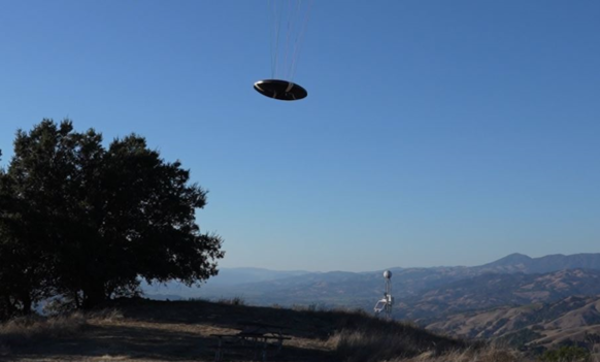
Flying Saucer Shark Deployed over the skies of California
Flying Saucer Shark Deployed over the skies of CaliforniaUSGS National Innovation Center UAS Research Center Saucer Shark Project, during flight tests, aeroshell. Saucer Shark on landing approach after completed mission. Just above the landing pad.

Saucer Shark Drop Release during testing campaign
USGS National Innovation Center UAS Research Center Saucer Shark Project, during flight tests, drop release attached to USGS UAV. Aircraft sits on landing pad in-between test flights.
USGS National Innovation Center UAS Research Center Saucer Shark Project, during flight tests, drop release attached to USGS UAV. Aircraft sits on landing pad in-between test flights.