
Aquifer
Aquifer
Filter Total Items: 10
Collaborations with EPA on Contaminated Site Hydrology
The U.S. Geological Survey (USGS), in cooperation with the U.S. Environmental Protection Agency (EPA), is developing tools and methods to help assess the fate and transport of anthropogenic and geologically sourced contaminants in the water cycle at waste sites throughout the nation.

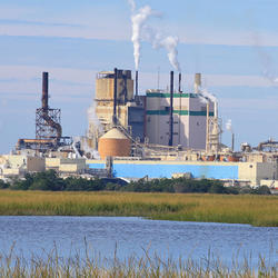
Augmented Site Characterization of PFAS Manufacturing and Processing Facilities
The U.S. Geological Survey (USGS) is supporting the U.S. Environmental Protection Agency (EPA) in assessing facilities nationwide that have historically produced per- and polyfluoroalkyl substances (PFAS) or used them in chemical manufacturing processes. In collaboration with EPA subcontractors, USGS is providing subject-matter expertise in PFAS fate and transport in the vadose zone and...

Detailed Characterization of the Savage Superfund Site, New Hampshire
The U.S. Geological Survey (USGS), in cooperation with the U.S. Environmental Protection Agency and the New Hampshire Department of Environmental Services, is conducting advanced site characterization activities at the Savage Municipal Water Supply Superfund site in Milford, New Hampshire, and implementing new remediation efforts based on USGS science and tools.

The Aqueous Flow Concentration Estimator (AFCE): Software for Estimation of Ambient Groundwater Flow in Bedrock Open Boreholes
The U.S. Geological Survey (USGS) developed a tool that uses a chemical budget approach to help determine which fractures in a fracture zone may be dominating the water chemistry of open boreholes in bedrock aquifers. The tool uses a Monte Carlo approach and measured concentrations of anthropogenic contaminants to simulate many different scenarios and predict the most likely source direction of...

Developing Synthetic Historical Record at Groundwater Wells Using Record Extension Techniques
The Groundwater Index in the Massachusetts Drought Management Plan provides a general overview of groundwater levels relative to long-term groundwater levels in Massachusetts. The methods used to compute the Groundwater Index were revised for the 2019 version of the Drought Management Plan. The 2019 plan aligns the drought categories and specifies the drought status from select percentile ranges...

Arsenic Variability in Water-Supply Wells
The USGS, in cooperation with the Town of Seabrook, New Hampshire and a private well owner, is assessing the variability of arsenic over multiple time scales. A network of three wells is being used to monitor changes in arsenic, arsenic species, a host of other chemical constituents, and the distribution of ages of groundwater entering the wells. The wells—one domestic bedrock aquifer well, one...

Geochemical Fingerprinting of Anthropogenic and Geologically Sourced Uranium at the Homestake Superfund Site, New Mexico
The U.S. Geological Survey (USGS), in cooperation with the U.S. Environmental Protection Agency, the Nuclear Regulatory Commission, and the New Mexico Environment Department, utilized a multiparameter geochemical-isotopic fingerprinting approach to differentiate anthropogenic and natural signatures of uranium contamination near the Homestake uranium mill Superfund site near Milan, New Mexico.

Recharge Estimates for Maine: 25-year Average, Range, and Uncertainty, 1990-2015
The USGS Soil-Water-Balance model (SWB) has been used to estimate potential recharge across the State of Maine. The average and range (minimum and maximum) of annual recharge were estimated for the 25-year period from 1990 to 2015. Datasets of estimated recharge and the modeled uncertainty in the recharge estimates are available for download.

Geospatial Dataset of Wells and Attributes in the New England Groundwater Level Network, 2017
The drought of 2016 affected hydrologic conditions throughout New England. Responses of USGS groundwater observation wells to this event, however, were not uniform and were sometimes markedly different from site to site. Although USGS scientists were able to provide explanations for most of these situations, the event highlighted the need for additional well information to develop quantitative and...

Preliminary Research into the Causes of Iron Fouling in Water at Roadway Construction Sites
The USGS and the New Hampshire Department of Transportation are conducting preliminary research into the causes of iron fouling in water at roadway construction sites where blasted bedrock is used as on-site fill material.